Comitancillo facts for kids
Quick facts for kids
Comitancillo
|
|
|---|---|
|
Municipality
|
|
| Country | |
| Department | |
| Area | |
| • Municipality | 138 km2 (53 sq mi) |
| Population
(2018 census)
|
|
| • Municipality | 59,489 |
| • Density | 431.1/km2 (1,116/sq mi) |
| • Urban | 9,034 |
| Climate | Cwb |
Comitancillo is a town and a special kind of area called a municipality in the San Marcos region of Guatemala. People there mostly speak the Mam language. Spanish people started the municipality of Comitancillo between 1633 and 1648. You can also find an old archaeological site called Chipel, which has cool remains from the ancient Mam culture.
Contents
History of Comitancillo and Tejutla

In 1690, the area of Tejutla was very large. It included many towns that are now separate municipalities. Some of these are Comitancillo, Ixchiguán, Concepción Tutuapa, Sipacapa, Sibinal, Tajumulco, Tacaná, and part of San Miguel Ixtahuacán.
According to old writings from Recordación Florida by Francisco Antonio de Fuentes y Guzmán, Tejutla was part of the Quetzaltenango Department. It was described as a "prosperous land" with good weather and plenty of water.
Tejutla: A Center of Trade and Religion
Tejutla was an important place for both trade and religion. In 1767, Joseph Domingo Hidalgo wrote that Tejutla was "El Curato." This meant it was the main trading center for all the towns around it.
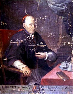
Later, in 1770, a bishop named Dr. Pedro Cortés y Larraz visited Tejutla. He called it "Santiago at the top of the hill." He reported that "sixty-four families who lived very well" were in the area.
Changes in Government and Power
In 1821, the constitution of the Central American United Provinces first showed Tejutla as part of the modern San Marcos region.
By 1870, Tejutla had grown enough to be called a "Villa" (a small town). Its leaders even asked the Guatemalan government to make it a department capital. This new department would have included many towns. Some of these towns are now in the Huehuetenango Department. Also, towns like Motocintla, Cacahuatán, and Tapachula were under the care of a religious group called the Mercedarians in Tejutla. These towns later became part of México in 1892.
However, things changed when a new group of leaders took over. Generals Miguel Garcia Granados and Justo Rufino Barrios won against the old government. They were called liberals. Once in power, they removed the Mercedarian religious group from Guatemala. This left Tejutla without its main leaders and support. The new government took away land and other properties from the Mercedarians. They then gave this land to their friends and supporters. These friends became big landowners in the area.
How to Visit Comitancillo
Comitancillo is the main town of the municipality. You can get there in a few ways:
- By taking the road that goes through San Lorenzo.
- By going through the villages of Serchil and Tuilelén.
- From the town of Tejutla.
- From the village of San Luis Tuimuj.
Climate
Comitancillo has a mild and pleasant climate. This type of climate is known as a temperate climate (Köppen: Cwb]).
| Climate data for Concepción Tutuapa | |||||||||||||
|---|---|---|---|---|---|---|---|---|---|---|---|---|---|
| Month | Jan | Feb | Mar | Apr | May | Jun | Jul | Aug | Sep | Oct | Nov | Dec | Year |
| Mean daily maximum °C (°F) | 19.4 (66.9) |
20.0 (68.0) |
21.6 (70.9) |
22.4 (72.3) |
22.1 (71.8) |
21.0 (69.8) |
20.9 (69.6) |
21.5 (70.7) |
20.9 (69.6) |
20.3 (68.5) |
20.1 (68.2) |
19.6 (67.3) |
20.8 (69.5) |
| Daily mean °C (°F) | 12.1 (53.8) |
12.4 (54.3) |
14.0 (57.2) |
15.3 (59.5) |
16.2 (61.2) |
15.9 (60.6) |
15.6 (60.1) |
15.7 (60.3) |
15.6 (60.1) |
15.0 (59.0) |
13.7 (56.7) |
12.8 (55.0) |
14.5 (58.2) |
| Mean daily minimum °C (°F) | 4.8 (40.6) |
4.9 (40.8) |
6.5 (43.7) |
8.3 (46.9) |
10.3 (50.5) |
10.9 (51.6) |
10.4 (50.7) |
9.9 (49.8) |
10.4 (50.7) |
9.7 (49.5) |
7.4 (45.3) |
6.1 (43.0) |
8.3 (46.9) |
| Average precipitation mm (inches) | 5 (0.2) |
6 (0.2) |
24 (0.9) |
61 (2.4) |
176 (6.9) |
274 (10.8) |
213 (8.4) |
222 (8.7) |
246 (9.7) |
176 (6.9) |
22 (0.9) |
10 (0.4) |
1,435 (56.4) |
| Source: Climate-Data.org | |||||||||||||
Where is Comitancillo Located?
Comitancillo is mostly surrounded by other towns in the San Marcos Department. However, on its eastern side, it shares a border with Cabricán. Cabricán is a town in the Quetzaltenango Department.
 |
San Miguel Ixtahuacán and Sipacapa |  |
||
| Tejutla and San Marcos | Cabricán, Quetzaltenango Department municipality Río Blanco, San Marcos Department municipality |
|||
| San Lorenzo and San Marcos |
See also
 In Spanish: Comitancillo para niños
 | Lonnie Johnson |
 | Granville Woods |
 | Lewis Howard Latimer |
 | James West |


