Conception Junction, Missouri facts for kids
Quick facts for kids
Conception Junction, Missouri
|
|
|---|---|

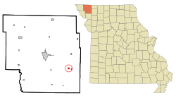
Location of Conception Junction, Missouri
|
|
| Country | United States |
| State | Missouri |
| County | Nodaway |
| Township | Jefferson |
| Area | |
| • Total | 0.32 sq mi (0.82 km2) |
| • Land | 0.32 sq mi (0.82 km2) |
| • Water | 0.00 sq mi (0.00 km2) |
| Elevation | 1,014 ft (309 m) |
| Population
(2020)
|
|
| • Total | 177 |
| • Density | 560.13/sq mi (216.08/km2) |
| Time zone | UTC-6 (Central (CST)) |
| • Summer (DST) | UTC-5 (CDT) |
| ZIP code |
64434
|
| Area code(s) | 660 |
| FIPS code | 29-15922 |
| GNIS feature ID | 2396659 |
Conception Junction is a small city in the state of Missouri, United States. It is located in the southeastern part of Nodaway County. According to the 2020 census, 177 people live in Conception Junction.
Contents
History of Conception Junction
The town of New Conception was started in 1895. This happened when a railroad line was built to the area. A post office, which handles mail, has been open here since 1907. It was named Conception Junction.
The city got its name because it was a meeting point for two important railroads. These were the Wabash and the Chicago Great Western Railroads. Both of these train lines are no longer in use today.
Geography and Location
Conception Junction is the biggest town in an area called the Tri-C Area. It is located about 1.5 miles north of Conception, which is home to Conception Abbey. The city is also one mile west of the village of Clyde.
The Platte River flows just west of Conception Junction. The United States Census Bureau says that the city covers a total area of about 0.31 square miles (0.82 square kilometers). All of this area is land.
Population and People
| Historical population | |||
|---|---|---|---|
| Census | Pop. | %± | |
| 1910 | 132 | — | |
| 1920 | 518 | 292.4% | |
| 1930 | 514 | −0.8% | |
| 1940 | 441 | −14.2% | |
| 1950 | 285 | −35.4% | |
| 1960 | 253 | −11.2% | |
| 1970 | 237 | −6.3% | |
| 1980 | 252 | 6.3% | |
| 1990 | 236 | −6.3% | |
| 2000 | 202 | −14.4% | |
| 2010 | 198 | −2.0% | |
| 2020 | 177 | −10.6% | |
| U.S. Decennial Census | |||
Population in 2010
In 2010, the census showed that 198 people lived in Conception Junction. There were 78 households, which are groups of people living together. About 48 of these were families.
The population density was about 638.7 people per square mile. This means that many people lived in a small area. All of the residents were White.
Households and Families
Out of the 78 households, about 38.5% had children under 18 years old living with them. More than half, about 51.3%, were married couples living together. A small number of households had a single parent.
About 33.3% of all households were made up of individuals living alone. Some of these individuals, about 12.8%, were 65 years old or older. The average household had 2.54 people. The average family had 3.33 people.
Age and Gender
The average age of people in the city was 34.3 years old. About 33.3% of the residents were under 18 years old. About 11.1% were 65 years old or older. The city had slightly more males (52.5%) than females (47.5%).
See also
 In Spanish: Conception Junction (Misuri) para niños
 | Aurelia Browder |
 | Nannie Helen Burroughs |
 | Michelle Alexander |

