Connecticut Route 146 facts for kids
Quick facts for kids
Route 146 |
||||
|---|---|---|---|---|

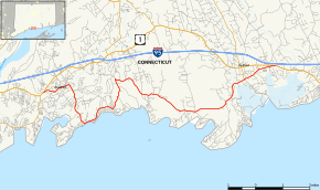
Map of New Haven County in southern Connecticut with Route 146 highlighted in red
|
||||
| Route information | ||||
| Maintained by ConnDOT | ||||
| Length | 13.00 mi (20.92 km) | |||
| Existed | 1932–present | |||
| Major junctions | ||||
| West end | ||||
| East end | ||||
| Location | ||||
| Counties: | New Haven | |||
| Highway system | ||||
| Routes in Connecticut Special Service Roads • State Roads
|
||||
Route 146 is a special road in Connecticut. It's a beautiful, scenic route that offers a different way to travel between the towns of Branford and Guilford. Think of it as a pretty detour from the busier US Route 1. This road is about 13 miles (21 kilometers) long. Most of it, about 8.4 miles (13.5 km), is in Branford, and the rest, about 4.6 miles (7.4 km), is in Guilford. It was officially named Route 146 in 1932.
Exploring Route 146
Route 146 starts in Branford as Main Street. It branches off from US Route 1 just east of the highway entrance to I-95. As you travel east, the road goes through Branford Center. It then becomes South Main Street, passing behind the town's green space.
Next, Route 146 turns south onto Montowese Street. It changes names a few times, becoming South Montowese Street and Sybil Avenue. These parts of the road lead you towards Indian Neck, a coastal area in Branford right by Long Island Sound.
The road then follows the coastline, changing names again to Limewood Avenue, Hotchkiss Grove Road, Elizabeth Street, and Pine Orchard Road. This section takes you into the Pine Orchard area of Branford.
At Pine Orchard, Route 146 turns north onto Blackstone Avenue and Totoket Road. The road then makes a sharp turn east onto Stony Creek Road. From there, it heads east and south onto Leetes Island Road.
Leetes Island Road then crosses into the town of Guilford. It briefly heads north on Sachem Head Road. Then it turns northeast onto Water Street. The road passes on the south side of the Guilford Town Green as Boston Street. Finally, it ends at US Route 1 east of the town center.
Along its path, Route 146 goes under Amtrak train tracks several times. It also crosses the Branford River and passes by Youngs Pond. A private school called Wightwood School is located on Stony Creek Road.
Special Features of Route 146
Route 146 is officially known as a "state-designated scenic road." This special designation begins about 0.84 miles (1.35 km) from its start in Branford, near Church Street. The scenic part continues for the rest of the route. This means it's a beautiful drive with lots of pretty views.
The section of Route 146 in Branford also has another name: the Edward Ramos Memorial Highway. This is to honor Edward Ramos, a Branford firefighter who sadly died while doing his job.
A large part of the road and the land next to it is also very old and important. From Flat Rock Road in Branford to the West River in Guilford, this area is a historic district. It's even listed on the National Register of Historic Places. This means it's a special place with a lot of history.
History of the Road
Route 146 became an official state road in 1932. This was part of a big plan to renumber many highways in Connecticut.
When it was first created, Route 146 started at the intersection of US 1 and Leetes Island Road in Branford. It then went south to its current path. From there, it continued east to what is now Route 77 in Guilford. It then went north along the current Route 77 to US 1.
In 1955, the eastern part of Route 146 was changed. It was rerouted to follow its current path along Boston Street. At the same time, Route 77 was extended south along the old Route 146 path.
Later, in 1962, Route 146 took over two other roads. It became the road to Indian Neck and Pine Orchard, which used to be called Route 143. It also included South Main Street, which was known as SR 445. At this time, Route 146 ended at US 1A (Main Street). The very next year, in 1963, US 1A was no longer used in Branford. Because of this, Main Street became part of Route 146.
Road Connections
The entire route is in New Haven County.
| Location | Mile | Roads intersected | Notes | ||||
|---|---|---|---|---|---|---|---|
| Branford | 0.00 | 0.00 | |||||
| Guilford | 11.69 | 18.81 | |||||
| 13.00 | 20.92 | ||||||
| 1.000 mi = 1.609 km; 1.000 km = 0.621 mi | |||||||
 | Selma Burke |
 | Pauline Powell Burns |
 | Frederick J. Brown |
 | Robert Blackburn |


