
Coolgardie, Western Australia facts for kids
Quick facts for kids CoolgardieWestern Australia |
|
|---|---|

Coolgardie Warden's Court
|
|

Coolgardie Marvel Bar RSL
|
|

Coolgardie
Location in Western Australia
|
|
| Established | 1892 |
| Postcode(s) | 6429 |
| Elevation | 428 m (1,404 ft) |
| Area | [convert: needs a number] |
| Location |
|
| LGA(s) | Shire of Coolgardie |
| State electorate(s) | Kalgoorlie |
| Federal Division(s) | O'Connor |
Coolgardie is a small town in Western Australia. It is about 558 kilometres (347 miles) east of Perth, the state capital. Today, around 850 people live there.
Even though Coolgardie is now known as a place for tourists and a mining ghost town, it was once the third largest town in Western Australia. Only Perth and Fremantle were bigger. Back then, finding gold in riverbeds was a huge industry. It gave new hope to the struggling economy. Many miners worked in very tough conditions. A few got lucky and found a lot of gold, making their hard work worth it. But most miners left poorer than they started, with their dreams broken.
Contents
Coolgardie's Gold Rush History


_(Kalgoorlie_region,_Western_Australia)_2_(16992820417).jpg)
Coolgardie started in 1892. This was when two prospectors, Arthur Wellesley Bayley and William Ford, found gold in an area called Fly Flat. Australia had many big gold rushes before this, mostly on the east coast. But by the 1890s, most of those goldfields were running out.
When gold was found in Coolgardie, a brand new gold rush began! Thousands of people rushed to the area. The Municipality of Coolgardie was set up in 1894. By 1898, Coolgardie was the third biggest town in the colony. It had about 5,008 people living there.
At its busiest time, 700 mining companies based in Coolgardie were listed on the London Stock Exchange. The town also had many businesses and services. These included a railway line connecting it to Perth and Kalgoorlie. It even had the first public swimming pool in the state! There were also many hotels and several newspapers.
Coolgardie was so important to the colony in the late 1890s. It was used to help convince Western Australia to join the Australian federation. Britain and the eastern colonies said they would create a new state called Auralia. This new state would be around Coolgardie and other goldfields like Kalgoorlie. This would happen if the government in Perth did not agree to vote on joining the federation.
Western Australia's government finally agreed. A vote was held just in time for them to become a founding state in the new federation in 1901. When this happened, Coolgardie was the centre of a federal voting area, the Division of Coolgardie. Soon after, in November 1901, Alf Morgans from Coolgardie briefly became the leader of Western Australia (the Premier of Western Australia).
However, the amount of gold found started to go down in the early 1900s. By World War I, the town was shrinking fast. The federal voting area was closed in 1913 because the population had dropped. Many people left for other towns where gold was still easy to find. Coolgardie soon stopped being a municipality (a self-governing town).
The situation stayed the same for many years. The population dropped to around 200 people, and it became almost a ghost town. For example, in March 1896, Coolgardie's main street had electric lights. But by April 1924, the same street was lit by just four hurricane lamps!
Even with this decline, many of the old buildings from the town's busy days were kept. This has helped the town start to grow again recently. Developing tourism has created some jobs in the town. This has led to a small increase in the number of people living there. Coolgardie now seems to be safe from disappearing completely.
Pictures of Coolgardie's Past
-
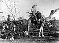
A prospector riding "Misery", a famous camel that travelled 965 kilometres (600 miles) without water in 1895.
-
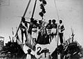
Aboriginal people taking part in a ceremony for the opening of the Coolgardie Railway Line in 1896.
-
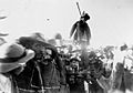
Miners burning a dummy of a prospector who lied about finding gold near Coolgardie in 1897.
-
The Coolgardie Chamber of Mines around 1900.


Muslim Afghan Cameleers

When the Coolgardie gold rush happened in 1894, the Afghan cameleers quickly moved in. These cameleers were called "Afghan" but some came from other countries. The goldfields could not have kept going without the food and water they carried.
In March 1894, a caravan of six Afghans, forty-seven camels, and eleven baby camels set off across the desert. They travelled from Marree to the goldfield. They arrived in July, with the camels in good shape. Each camel carried between 135 and 270 kilograms (298 and 595 pounds). Another fifty-eight camels for Coolgardie arrived by ship in Albany in September.
By 1898, there were 300 Muslim people in Coolgardie. About 80 of them attended Friday prayers regularly. Coolgardie had the main Muslim community in the colony at that time. There were no Muslim women among them, and no marriages or burials happened. This shows it was a community of mostly young men who moved around a lot.
Just like other buildings, simple mud and tin-roofed mosques were built in the town at first. Over time, all the Afghan Muslim people moved away from Coolgardie, mostly to Perth. The cameleers faced challenges and were not always treated fairly. There were reports of unsolved problems and harm to their animals.
Getting Around Coolgardie
The Great Eastern Highway (also known as National Highway 94) goes right through Coolgardie. It is called Bayley Street in town. Just east of Coolgardie, Highway 94 turns south onto the Coolgardie-Esperance Highway. This road goes towards Norseman, which is where the route across the Nullarbor Plain begins.
The original narrow-gauge railway to Kalgoorlie, called the Eastern Goldfields Railway, used to pass through Coolgardie. But in 1968, a new standard-gauge line was built to the north on a different path.
The Transwa Prospector train stops about 14 kilometres (9 miles) north of Coolgardie at Bonnie Vale. There is a very limited public bus service to the town on the Kalgoorlie to Perth route. However, school bus services are more frequent.
Coolgardie's Weather
| Climate data for Coolgardie | |||||||||||||
|---|---|---|---|---|---|---|---|---|---|---|---|---|---|
| Month | Jan | Feb | Mar | Apr | May | Jun | Jul | Aug | Sep | Oct | Nov | Dec | Year |
| Mean daily maximum °C (°F) | 33.3 (91.9) |
32.3 (90.1) |
29.4 (84.9) |
24.9 (76.8) |
20.3 (68.5) |
16.9 (62.4) |
16.1 (61.0) |
18.1 (64.6) |
22.0 (71.6) |
25.1 (77.2) |
29.3 (84.7) |
32.3 (90.1) |
25.0 (77.0) |
| Mean daily minimum °C (°F) | 17.0 (62.6) |
16.8 (62.2) |
15.1 (59.2) |
12.0 (53.6) |
8.6 (47.5) |
6.5 (43.7) |
5.2 (41.4) |
5.9 (42.6) |
7.9 (46.2) |
10.2 (50.4) |
13.4 (56.1) |
15.8 (60.4) |
11.2 (52.2) |
| Average precipitation mm (inches) | 23.4 (0.92) |
27.5 (1.08) |
25.3 (1.00) |
21.7 (0.85) |
28.0 (1.10) |
28.8 (1.13) |
23.8 (0.94) |
23.6 (0.93) |
13.6 (0.54) |
16.0 (0.63) |
16.4 (0.65) |
17.1 (0.67) |
265.2 (10.44) |
| Average rainy days (≥ 1 mm) | 2 | 2.1 | 2.5 | 2.7 | 3.7 | 4.3 | 4.5 | 3.7 | 2.4 | 2.2 | 2.1 | 1.9 | 34.1 |
| Average afternoon relative humidity (%) (at 3 pm) | 23 | 25 | 29 | 37 | 42 | 48 | 47 | 39 | 28 | 24 | 23 | 21 | 32 |
| Source: (temperatures 1897-1953, humidity 1938-1953, rainfall 1893-2024) | |||||||||||||
Gold Mining Areas
In the 1890s, four gold mining areas were officially named, using Coolgardie as a key reference point:
- Coolgardie Goldfield (1894)
- East Coolgardie Goldfield (1894)
- North Coolgardie Goldfield (1895)
- North-east Coolgardie Goldfield (1896)
Even with all the changes in the Kalgoorlie region, Coolgardie still has a Mining Registrar. This is an official who keeps records related to mining.
See also
 In Spanish: Coolgardie para niños
