Corfu, New York facts for kids
Quick facts for kids
Corfu, New York
|
|
|---|---|

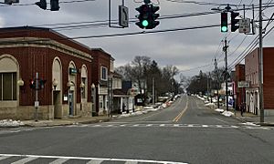
Looking eastward down East Main Street, January 2021
|
|

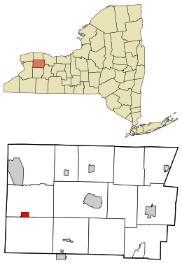
Location in Genesee County and the state of New York
|
|
| Country | United States |
| State | New York |
| County | Genesee |
| Town | Pembroke |
| Area | |
| • Total | 0.99 sq mi (2.58 km2) |
| • Land | 0.99 sq mi (2.58 km2) |
| • Water | 0.00 sq mi (0.00 km2) |
| Elevation | 863 ft (263 m) |
| Population
(2020)
|
|
| • Total | 689 |
| • Density | 692.46/sq mi (267.33/km2) |
| Time zone | UTC-5 (Eastern (EST)) |
| • Summer (DST) | UTC-4 (EDT) |
| ZIP code |
14036
|
| Area code(s) | 585 |
| FIPS code | 36-18201 |
| GNIS feature ID | 0947446 |
Corfu (pronounced KOR-fyoo) is a small village located in Genesee County, New York, in the United States. In 2010, about 709 people lived there. The village gets its name from the beautiful Greek island of Corfu.
Most of Corfu village is in the town of Pembroke. A tiny part of it is also in the town of Darien, which is to the south.
Contents
A Look Back at Corfu's History
Before it was called Corfu, this area was known as "Longs Corners." The name "Corfu" was chosen when a post office was first opened here. The village of Corfu officially became an incorporated village in 1868. This means it became its own local government.
Where is Corfu Located?
Corfu is found in the western part of Genesee County. You can find it at these coordinates: 42.958662 degrees North and -78.403938 degrees West.
Main Roads and Nearby Places
New York State Route 33 goes through the village. It is known as Main Street. If you go east on Route 33, you will reach Batavia, which is about 11 miles away. Batavia is the main town, or county seat, for Genesee County. Going west on Route 33 will take you to Buffalo, about 26 miles away.
New York State Route 77 also crosses Route 33 in the middle of Corfu. Route 77 is called Alleghany Road. Going north on Route 77 leads to Lockport, about 27 miles away. Going south on Route 77 takes you to Java Center, about 22 miles away.
Corfu is conveniently located between two popular spots. It is about 3 miles from Six Flags Darien Lake to the south. It is also about 3 miles from the New York State Thruway to the north.
Size and Waterways
The village of Corfu covers a total area of about 2.6 square kilometers (or 0.99 square miles). All of this area is land.
A stream called Murder Creek flows through the western part of the village. This creek is a branch of Tonawanda Creek.
Who Lives in Corfu?
| Historical population | |||
|---|---|---|---|
| Census | Pop. | %± | |
| 1880 | 353 | — | |
| 1890 | 398 | 12.7% | |
| 1900 | 401 | 0.8% | |
| 1910 | 413 | 3.0% | |
| 1920 | 458 | 10.9% | |
| 1930 | 418 | −8.7% | |
| 1940 | 462 | 10.5% | |
| 1950 | 542 | 17.3% | |
| 1960 | 616 | 13.7% | |
| 1970 | 722 | 17.2% | |
| 1980 | 689 | −4.6% | |
| 1990 | 755 | 9.6% | |
| 2000 | 795 | 5.3% | |
| 2010 | 709 | −10.8% | |
| 2020 | 689 | −2.8% | |
| U.S. Decennial Census | |||
In 2000, there were 795 people living in Corfu. These people lived in 309 households, and 211 of these were families. The village had about 336 housing units.
About 97% of the people in the village were White. A small number of residents were African American, Native American, or from other backgrounds. About 1% of the population was Hispanic or Latino.
Age Groups in the Village
The population in Corfu was spread out across different age groups.
- About 28% of the people were under 18 years old.
- About 33% were between 25 and 44 years old.
- About 12% were 65 years old or older.
The average age of people in the village was 35 years old.
See also
 In Spanish: Corfu (Nueva York) para niños

