Corner River facts for kids
Quick facts for kids Corner River |
|
|---|---|

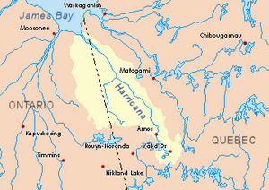
Harricana River basin in yellow
|
|
| Country | Canada |
| Province | Ontario |
| Physical characteristics | |
| Main source | Corner Lakes District of Cochrane, Ontario 266 m (873 ft) 50°07′06″N 79°39′57″W / 50.11833°N 79.66583°W |
| River mouth | Harricana River District of Cochrane, Ontario 7 m (23 ft) 50°55′40″N 79°32′08″W / 50.92778°N 79.53556°W |
| Length | 65.2 km (40.5 mi) |
The Corner River is a cool river in Ontario, Canada. It flows into a bigger river called the Harricana River. You can find it in the Cochrane District.
During winter, the river usually freezes from early November until mid-May. However, it's generally safe to walk or travel on the ice from mid-November to the end of April.
Contents
Where is the Corner River?
The Corner River is located in the Cochrane District of Ontario. It's part of a network of rivers and lakes in this area.
Rivers Nearby
Many other rivers are close to the Corner River. These rivers form different watersheds, which are areas of land where all the water drains into a common river or lake.
- To the north: The Harricana River
- To the east: The Harricana River, Again River, Mannerelle River, and Malouin River
- To the south: The Corner Lakes and Detour River
- To the west: The Kattawagami River, Lawagamau River, Seal River, and Atik River
Where Does the Corner River Start?
The Corner River begins in a group of lakes known as the "Corner Lakes." These lakes are in the eastern part of the Cochrane District. The river starts from an unnamed lake within this group. This starting lake is about 2.3 meters long and sits at an altitude of 269 meters.
The very beginning of the Corner River is located:
- About 8.4 kilometers east of the border between Ontario and Quebec.
- About 72.5 kilometers south of where the Corner River joins the Harricana River.
- About 40.8 kilometers east of Kesagami Lake in Ontario.
How Does the River Flow?
From its source, the Corner River flows for about 65.2 kilometers. It generally runs alongside the border between Ontario and Quebec.
Here's how it flows:
- It travels north for about 19.9 kilometers through marshy areas.
- Then, it continues north for another 22.1 kilometers, still in marshy areas, until it reaches the Quebec border.
- It flows north for 15.8 kilometers into Quebec through more marshland.
- Next, it goes north for 21.8 kilometers in a marshy area.
- Finally, it turns northwest for 7.4 kilometers, making a big curve, until it reaches its mouth.
Where Does the Corner River End?
The Corner River flows into the Harricana River. It joins the Harricana River on its southwestern shore, right across from a place called Low Shoal Island.
This meeting point is located:
- About 32.1 kilometers southeast of where the Harricana River itself flows into James Bay.
- About 4.3 kilometers west of the border between Quebec and Ontario.
- About 83.1 kilometers south of the town of Moosonee in Ontario.
What's in a Name?
The name "Corner River" comes from the English language. It's called this because the river's mouth flows into a bend, or "corner," of the Harricana River. This bend is right in front of Low Shoal Island.
Sailors who used to travel on the Harricana River towards James Bay would pass this river bend. The lakes where the Corner River starts are also known as "Corner Lakes."
 | Georgia Louise Harris Brown |
 | Julian Abele |
 | Norma Merrick Sklarek |
 | William Sidney Pittman |

