Cortland, Nebraska facts for kids
Quick facts for kids
Cortland, Nebraska
|
|
|---|---|
|
Village
|
|

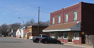
Downtown Cortland: 4th Street
|
|

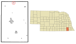
Location of Cortland, Nebraska
|
|
| Country | United States |
| State | Nebraska |
| County | Gage |
| Township | Highland |
| Area | |
| • Total | 0.26 sq mi (0.68 km2) |
| • Land | 0.26 sq mi (0.68 km2) |
| • Water | 0.00 sq mi (0.00 km2) |
| Elevation | 1,447 ft (441 m) |
| Population
(2020)
|
|
| • Total | 504 |
| • Density | 1,916.35/sq mi (740.15/km2) |
| Time zone | UTC-6 (Central (CST)) |
| • Summer (DST) | UTC-5 (CDT) |
| ZIP code |
68331
|
| Area code(s) | 402 |
| FIPS code | 31-10635 |
| GNIS feature ID | 2398631 |
Cortland is a small village located in Gage County, Nebraska, in the United States. In 2020, about 504 people lived there, according to the 2020 census.
Contents
History of Cortland
Cortland started in 1884. That's when the railroad tracks reached this area. When a town is "platted," it means its streets and lots are officially mapped out. At first, the village was sometimes called "Galesburg." Later, it was named Cortland, just like the city of Cortland, New York.
Geography of Cortland
Cortland is a small place, covering about 0.26 square miles (or 0.68 square kilometers) of land. It has no large bodies of water within its borders.
The village is located about 20 miles south of Lincoln. It is also about 18 miles north of Beatrice. You can find Cortland along U.S. Route 77. The village is part of the Norris School District 160. This school district has its main office in Firth.
People of Cortland
The number of people living in Cortland has changed over the years. Here's a quick look at the population from different census counts:
| Historical population | |||
|---|---|---|---|
| Census | Pop. | %± | |
| 1890 | 509 | — | |
| 1900 | 390 | −23.4% | |
| 1910 | 364 | −6.7% | |
| 1920 | 322 | −11.5% | |
| 1930 | 318 | −1.2% | |
| 1940 | 307 | −3.5% | |
| 1950 | 288 | −6.2% | |
| 1960 | 285 | −1.0% | |
| 1970 | 326 | 14.4% | |
| 1980 | 403 | 23.6% | |
| 1990 | 393 | −2.5% | |
| 2000 | 488 | 24.2% | |
| 2010 | 482 | −1.2% | |
| 2020 | 504 | 4.6% | |
| U.S. Decennial Census | |||
Cortland in 2010
In 2010, the census counted 482 people living in Cortland. There were 204 households and 138 families. The village had about 1853 people per square mile. Most of the people living in Cortland were White (98.8%). A small number were Native American or Asian.
About 31.4% of households had children under 18 living with them. Most households (59.3%) were married couples. About 24.5% of all households were people living alone. Roughly 12.2% of these were people aged 65 or older. The average household had 2.36 people.
The average age of people in the village was 40.4 years. About 24.1% of residents were under 18. About 18% were 65 years old or older. The village had slightly more males (50.8%) than females (49.2%).
In 2010, the average yearly income for a household was $60,417. For families, it was $70,278. The average income per person was $27,284. Most working people (238 out of 271) traveled to another town for work. The average commute time was about 27 minutes.
Education
The school district for Cortland is Norris School District 160. Students in Cortland attend schools within this district.
See also
 In Spanish: Cortland (Nebraska) para niños
 | Misty Copeland |
 | Raven Wilkinson |
 | Debra Austin |
 | Aesha Ash |

