Cowley Beach, Queensland facts for kids
Quick facts for kids Cowley BeachQueensland |
|||||||||||||||
|---|---|---|---|---|---|---|---|---|---|---|---|---|---|---|---|

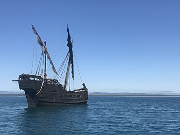
The "Notorious" anchored near Hutchison Island off Cowley Beach, 2017
|
|||||||||||||||
| Population | 65 (2021 census) | ||||||||||||||
| • Density | 0.451/km2 (1.17/sq mi) | ||||||||||||||
| Postcode(s) | 4871 | ||||||||||||||
| Area | 144.0 km2 (55.6 sq mi) | ||||||||||||||
| Time zone | AEST (UTC+10:00) | ||||||||||||||
| Location | |||||||||||||||
| LGA(s) | Cassowary Coast Region | ||||||||||||||
| State electorate(s) | Hill | ||||||||||||||
| Federal Division(s) | Kennedy | ||||||||||||||
|
|||||||||||||||
Cowley Beach is a small coastal town in Queensland, Australia. It's known for its beautiful beach. In 2021, only 65 people lived here. It is part of the Cassowary Coast Region.
Contents
Exploring Cowley Beach's Geography
Cowley Beach is surrounded by nature. The Moresby River is to its north. The big Coral Sea is to the east. Liverpool Creek is to the south.
Military Training Area
A large part of Cowley Beach is used by the Australian Defence Force. This area is called the Cowley Beach Military Training Area. It includes the northern beach and nearby Lindquist Island. Soldiers use this area for special training. They practice moving from water to land, which is called amphibious warfare. There is also a rocket range and a camp area for soldiers.
Mountains and Headlands
Cowley Beach has a few small mountains:
- Esmeralda Hill, about 100 metres (328 feet) tall.
- Georgie Hill, about 140 metres (459 feet) tall.
There are also several coastal headlands, which are points of land sticking out into the sea:
- Camp Point
- Hall Point
- Hayter Point
- Double Point
Beaches to Discover
Cowley Beach has several lovely beaches:
- Robinsons Beach, located south of Hayter Point.
- Browns Beach, found north of Double Point.
- Cowley Beach, the main beach, south of Double Point.
Islands Near the Coast
There are many islands off the coast of Cowley Beach:
- Lindquist Island
- Bresnahan Island
- North Barnard Islands, a group of islands named in 1819. This group includes:
- Jessie Island
- Hutchison Island, named after Lieutenant Hutchison.
- Kent Island, named after a lightkeeper.
There are also islands within the Moresby River:
- Bradshaw Island
- Lily Island
- Maizie Island
A Look at Cowley Beach's History
The town and beach are named after Ebenezer Cowley. He was a gardener and manager at a plant nursery. Before November 1991, the town was called Inarlinga.
In the 1930s, a public area was set up along Cowley Beach. It quickly became a popular spot for people on holiday.
Military Training History
The Cowley Beach Military Training Area started in 1962. It was first known as the Joint Tropical Research Unit. It worked with the British Ministry of Defence.
Who Lives in Cowley Beach?
In 2016, 78 people lived in Cowley Beach. By 2021, the population was 65 people.
Schools Near Cowley Beach
There are no schools right in Cowley Beach. Kids usually go to Silkwood State School for primary school. This school is in Silkwood, to the south-west. For high school, students go to Innisfail State College in Innisfail, which is to the north.
Things to Do in Cowley Beach
There is a boat ramp on Bambarook Road. It is managed by the local council. This is a great spot for launching boats.
Enjoy the Beach
Cowley Beach itself is a long beach, stretching about 7.5 kilometres (4.7 miles). It goes from Double Point all the way to the mouth of Liverpool Creek. It's a perfect place to relax and enjoy the coast.
 | Laphonza Butler |
 | Daisy Bates |
 | Elizabeth Piper Ensley |


