Mourilyan Harbour facts for kids
Quick facts for kids Mourilyan HarbourQueensland |
|||||||||||||||
|---|---|---|---|---|---|---|---|---|---|---|---|---|---|---|---|

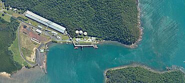
Mourilyan Harbour port facilities
|
|||||||||||||||
| Population | 142 (2021 census) | ||||||||||||||
| • Density | 5.299/km2 (13.72/sq mi) | ||||||||||||||
| Postcode(s) | 4858 | ||||||||||||||
| Area | 26.8 km2 (10.3 sq mi) | ||||||||||||||
| Time zone | AEST (UTC+10:00) | ||||||||||||||
| Location |
|
||||||||||||||
| LGA(s) | Cassowary Coast Region | ||||||||||||||
| State electorate(s) | Hill | ||||||||||||||
| Federal Division(s) | Kennedy | ||||||||||||||
|
|||||||||||||||
Mourilyan Harbour is a small coastal town and port in Queensland, Australia. It is located in the Cassowary Coast Region. In 2021, about 142 people lived there. This area is mostly known for its busy port, which helps export sugar and other goods.
Contents
Where is Mourilyan Harbour?
Mourilyan Harbour is right on the coast, next to the Coral Sea. The Moresby River and its smaller creeks form its southern border. The main port area is on the northern side of the Moresby River's mouth.
What is the land used for?
The port is mainly used to send out raw sugar and molasses. It also handles other products like woodchips and cattle. A road called Mourilyan Harbour Road connects the port to the nearby town of Mourilyan. Most of the land around the port is used for growing sugarcane.
A Look at Mourilyan Harbour's Past
How Mourilyan Harbour Got Its Name
In 1872, a naval captain named John Moresby explored the coast. He mapped Mourilyan Harbour while on his ship, HMS Basilisk. He named the harbour after one of his officers, Lieutenant T. L. Mourilyan. Captain Moresby thought it was a great spot for ships to dock because the water was deep.
Early Developments and Growth
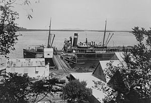
In the early 1880s, a small jetty was built. A jetty is like a pier where boats can load and unload. In 1884, work began on a special railway, called a tramway. This tramway connected the harbour to the sugar mill in Mourilyan. By 1889, the harbour could handle larger ships, up to 1,500 tons. A second jetty was also built with a conveyor belt to help move goods.
The Innisfail Tramway's Role
From 1903, a bigger tramway project started. It was first called the Geraldton Tramway, but later renamed the Innisfail Tramway. This tramway was very important for moving harvested sugar cane to the mill. After the sugar was processed, it was taken to the harbour for shipping. The tramway also carried passengers and tourists.
Modernizing the Port for Sugar
Between 1922 and 1924, the Queensland Government built a large wharf. It was about 416 feet (127 meters) long and had big sheds to store sugar. In 1924, the North Coast railway line from Brisbane to Cairns was finished. This meant fewer passengers used the harbour, but the sugar industry was growing. So, the harbour became mainly focused on shipping sugar.
After World War II, the Queensland Government decided to improve sugar handling at only six ports. Mourilyan Harbour was one of them. In 1957, a ship carrying sugar got stuck near the harbour entrance. This led to a major upgrade of the harbour. By June 1960, the port could handle bulk sugar. A new, large conveyor belt could load sugar onto ships very quickly. It could load 863 tonnes (about 950 tons) per hour! This made it one of the biggest raw sugar handling ports in the world. A special board was set up to run the port. In 1971, the sugar storage sheds were made even bigger.
In 1997, it was decided that trains were no longer needed to carry sugar directly to the wharf. That part of the railway line was removed. However, farmers still use the line to transport sugar cane to the mill.
Population of Mourilyan Harbour
In 2021, the population of Mourilyan Harbour was 142 people. This number has changed a bit over the years. For example, in 2016, there were 156 people living there.
What the Port Exports
The port at Mourilyan Harbour is a key place for exporting sugar and molasses. These products come from areas like Innisfail, Babinda, Tully, and the Atherton Tableland. The port also sends out woodchips and logs.
Schools Near Mourilyan Harbour
There are no schools directly in Mourilyan Harbour. The closest primary school is Mourilyan State School, which is in the neighbouring town of Mourilyan. For high school, students usually go to Innisfail State College in Innisfail Estate.
Fun Activities in Mourilyan Harbour
Mourilyan Harbour is a popular spot for fishing. It has many creeks and channels lined with mangroves. People often catch fish like barramundi, mangrove jacks, giant trevally, and queenfish here. However, it's important to be careful when it's windy, as the water can get very rough.
 | Aaron Henry |
 | T. R. M. Howard |
 | Jesse Jackson |


