Mourilyan, Queensland facts for kids
Quick facts for kids MourilyanQueensland |
|||||||||||||||
|---|---|---|---|---|---|---|---|---|---|---|---|---|---|---|---|

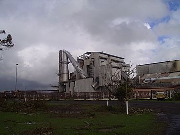
The Mourilyan sugar mill after Cyclone Larry
|
|||||||||||||||
| Population | 509 (2021 census) | ||||||||||||||
| Postcode(s) | 4858 | ||||||||||||||
| Location | |||||||||||||||
| LGA(s) | Cassowary Coast Region | ||||||||||||||
| State electorate(s) | Hill | ||||||||||||||
| Federal Division(s) | Kennedy | ||||||||||||||
|
|||||||||||||||
Mourilyan is a small town and an area (called a locality) in Queensland, Australia. It's part of the Cassowary Coast Region. The town grew up around the Mourilyan sugar mill, which gave most people jobs. However, a powerful storm called Cyclone Larry destroyed the mill on March 20, 2006. In 2021, about 509 people lived in Mourilyan.
Contents
Where is Mourilyan?
Mourilyan is located about 8 kilometres (5 miles) south of Innisfail. You can find it along the Bruce Highway, which is a major road in Queensland.
Mourilyan's Past
Building the Sugar Mill
The Mourilyan sugar mill started being built in 1882. This makes it one of the oldest sugar mills in Australia! Many people helped to build it. Workers from the Pacific Islands, known as Kanakas, did most of the digging. They were also helped by Chinese and Anglo-Saxon labourers. When the mill was finished in 1884, it could process 14 tonnes (about 15 short tons) of sugar in just 12 hours.
In 1913, a big company called the Colonial Sugar Refining Company (now known as CSR) started buying sugar from the Mourilyan mill. Even with the mill, Mourilyan stayed a small town and didn't grow much for a long time.
Post Office and Church
The Mourilyan Post Office opened in September 1910. Before that, a smaller "receiving office" had been open since 1884, when the mill first started.
The Christ the King Catholic Church is located at 10 Harbour Road. It is part of the Innisfail Parish of the Roman Catholic Diocese of Cairns. The local Catholic church area (parish) was set up in 1935.
Facing Tropical Cyclones
Mourilyan is in an area where tropical cyclones often happen. These are very strong storms with powerful winds and heavy rain.
- In 1918, a cyclone caused serious damage to the mill and the town. This really affected how much sugar could be made that year.
- In 1986, Cyclone Winifred also caused a lot of damage to the area.
- In March 2006, Cyclone Larry hit Mourilyan hard. It damaged many homes and completely destroyed the sugar mill, which was the town's main source of jobs. The Australian Defence Force (Australia's military) helped a lot to get Mourilyan Primary School working again. Insurance money also helped people fix their homes and businesses.
Population of Mourilyan
According to the 2021 census, the locality of Mourilyan had a population of 509 people.
Things to See and Do
Mourilyan's main attraction is the Australian Sugar Industry Museum. This museum has many old items and stories from North Queensland's long history of growing and processing sugar. It's a great place to learn about how sugar was made in the past!
The town also serves as a starting point to visit other interesting places nearby, like Mourilyan Harbour, Etty Bay (a beautiful beach), and Paronella Park (a historic castle-like park).
Education in Mourilyan
Mourilyan State School opened its doors on January 29, 1908. As of July 2017, the school teaches 167 students from Prep (the first year of school) up to Year 6.
 | Aaron Henry |
 | T. R. M. Howard |
 | Jesse Jackson |


