Coyote Creek Trail facts for kids
Quick facts for kids Coyote Creek Trail |
|
|---|---|
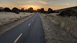
Coyote Creek Trail near Bailey at sunset
|
|
| Length | 18.7 miles (30.1 km) |
| Location | Santa Clara County, California |
| Designation | National Recreation Trail |
| Cycling details | |
| Surface | paved |
The Coyote Creek Trail is a super cool path for walking, running, and biking! It follows along Coyote Creek in San Jose, California. This trail also goes through Coyote Valley and into northern Morgan Hill.
In 2009, the Coyote Creek Trail became a special part of the National Recreation Trail system. This means it's recognized as an important path for outdoor fun. It's also connected to the bigger Bay Area Ridge Trail system.
Contents
Exploring the Coyote Creek Trail
The Coyote Creek Trail is about 18.7 miles long. It's a great place to get outside and enjoy nature. The trail is mostly paved, which makes it easy for bikes, strollers, and wheelchairs.
Trail Sections in San Jose
A big part of the trail is right inside the city of San Jose. The very northern end of the trail is close to the bottom tip of San Francisco Bay.
Right now, the trail isn't one long continuous path in San Jose. There are a few separate sections:
- A paved part runs between the Highway 237 Bikeway and Tasman Drive.
- You can find a short, separate piece near Berryessa Road. This is close to the San Jose Flea Market and the Berryessa BART Station.
- Another paved section starts at Tully Road and goes south for about 2 miles. This part connects to Hellyer County Park.
Art Along the Trail
Did you know there's art on the trail? In 2004, two artists, Deborah Kennedy and Diana Pumpelly Bates, created public artworks for the Coyote Creek Trail. Their art helps people learn about the trail and makes it easier to access. For example, their work helps people find ramps that lead to the path.
Coyote Creek Parkway: The County Section
The southern part of the trail is looked after by Santa Clara County. This section is called the Coyote Creek Parkway. It includes the trail itself and a chain of county parks along the creek.
This county part of the trail is about 15 miles long. It's paved all the way from Hellyer County Park to Anderson Lake.
Cool Places Along the Trail
The Coyote Creek Trail passes by many interesting spots. Here are some of them:
In San Jose
- North San Jose segment (about 1.0 mile long)
- Connects to the Highway 237 Bikeway.
- Near the VTA light rail Cisco Way station.
- Berryessa District segment (about 0.25 miles long)
- Close to the San Jose Flea Market.
- Near the Berryessa BART Station.
- South San Jose segment (about 2.5 miles long)
- This part connects directly to Hellyer County Park.
In Santa Clara County
- This section is about 15 miles long.
- Hellyer County Park is a great place to start or end your trip.
- You can also find the Hellyer Park Velodrome here, which is a special track for bicycle racing.
- The trail goes through the small town of Coyote, California.
- It passes by the Santa Clara County Model Aircraft Skypark, where people fly model airplanes.
- The trail ends at Anderson Lake County Park, a beautiful lake area.
Images for kids
 | George Robert Carruthers |
 | Patricia Bath |
 | Jan Ernst Matzeliger |
 | Alexander Miles |


