Coyote Hills (Alameda County) facts for kids
Quick facts for kids Coyote Hills |
|
|---|---|
 |
|
| Highest point | |
| Elevation | 68 m (223 ft) |
| Geography | |
| Country | United States |
| State | California |
| District | Alameda County |
| Range coordinates | 37°32′31.771″N 122°5′8.867″W / 37.54215861°N 122.08579639°W |
| Topo map | USGS Newark |
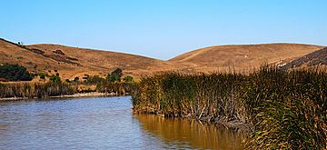
The Coyote Hills are a group of small hills in Alameda County, California. They are not very tall, reaching an elevation of about 68 meters (223 feet) at their highest point. These hills are a natural part of the landscape in the San Francisco Bay Area.
Contents
What are the Coyote Hills?
The Coyote Hills are a low mountain range, which means they are a series of connected hills. They are much smaller than large mountains. These hills are a special part of the natural environment in Northern California.
Where are the Coyote Hills located?
You can find the Coyote Hills in Alameda County, which is in the state of California. They are part of the larger San Francisco Bay Area. This area is known for its diverse landscapes, from busy cities to quiet natural spaces.
What is Coyote Hills Regional Park?
A very important place called Coyote Hills Regional Park is located right within these hills. The park is named after the hills themselves. Regional parks like this one are created to protect nature and give people a place to enjoy the outdoors.
Why are regional parks important?
Regional parks are super important for many reasons:
- They protect natural habitats for plants and animals. This helps keep different species safe.
- They offer places for people to do fun activities like hiking, biking, and birdwatching.
- They help us learn about nature and the environment.
- They provide green spaces in areas that might otherwise be very developed.
 | William L. Dawson |
 | W. E. B. Du Bois |
 | Harry Belafonte |


