
Crafton, Pennsylvania facts for kids
Quick facts for kids
Crafton, Pennsylvania
|
|
|---|---|
|
Borough
|
|

Intersection of East Crafton, Noble and Dinsmore Avenues in Crafton, PA.
|
|

Location in Allegheny County and the U.S. state of Pennsylvania.
|
|
| Country | United States |
| State | Pennsylvania |
| County | Allegheny |
| Government | |
| • Type | Borough |
| • Body | Borough Council |
| Area | |
| • Total | 1.14 sq mi (2.96 km2) |
| • Land | 1.14 sq mi (2.96 km2) |
| • Water | 0.00 sq mi (0.00 km2) |
| Population
(2020)
|
|
| • Total | 6,099 |
| • Density | 5,340.63/sq mi (2,061.41/km2) |
| Time zone | UTC−5 (EST) |
| • Summer (DST) | UTC−4 (EDT) |
| ZIP Code |
15205
|
| Area code(s) | 412 |
| FIPS code | 42-16848 |
| Website | Crafton Borough |
Crafton is a small town, called a borough, located in Allegheny County, Pennsylvania. It's just west of downtown Pittsburgh. In 2020, about 6,099 people lived there. Crafton is a quiet, residential area that's part of the larger Pittsburgh metropolitan area.
Contents
History of Crafton
Before European settlers arrived, the land where Crafton now stands was home to Native American tribes. The Seneca Indians lived here, and some believe their famous chief, Cornplanter, called this area Killemun.
Ancient Inhabitants and Burial Mounds
Even before the Seneca, other groups lived in the Crafton area. Historians have found burial mounds from a very old group called the Adena Culture. These mounds were found near Chartiers Creek, which flows through the area. In 1896, the Carnegie Museum explored one of these sites and found many ancient burials. These early people are thought to be from the Algonquin group. Sadly, many of these ancient sites were destroyed over time as new buildings and industries grew.
Early European Exploration and Settlement
Chartiers Creek was a very important natural feature in the past. It winds its way northwest to the Ohio River near McKees Rocks. In the mid-1700s, the French claimed land in this valley. Even George Washington traveled through this area for the first time in 1752.
How Crafton Got Its Name
Crafton is named after James S. Craft. He was a lawyer who owned land near the "forks of the Ohio" in what is now Oakland. He used money from selling that land to buy more land in the Chartiers valley. After James Craft passed away, his son, Charles Craft, divided the land into smaller pieces. He officially named the area Crafton when he registered it with the Allegheny County Courthouse. Crafton officially became a borough on January 8, 1892, and Charles Craft was its first leader, called a burgess.
Trolley Connection to Pittsburgh
In 1896, Crafton got a special connection to downtown Pittsburgh: a trolley line! This made it much easier for people to travel. However, the trolley service eventually stopped when the Fort Pitt Bridge was built without tracks for the trolleys.
Geography of Crafton
Crafton is located at 40°26′2″N 80°4′5″W / 40.43389°N 80.06806°W. It covers about 1.1 square miles, and all of it is land.
Neighboring Areas
Crafton shares its borders with several other towns and Pittsburgh neighborhoods. To the north is Ingram. To the northeast is Crafton Heights, and to the east is Westwood. South of Crafton are Oakwood and East Carnegie. To the northwest, you'll find Fairywood. Across Chartiers Creek, Crafton is next to Thornburg to the west and Rosslyn Farms to the southwest.
Population Information
| Historical population | |||
|---|---|---|---|
| Census | Pop. | %± | |
| 1900 | 1,927 | — | |
| 1910 | 4,583 | 137.8% | |
| 1920 | 5,954 | 29.9% | |
| 1930 | 7,004 | 17.6% | |
| 1940 | 7,163 | 2.3% | |
| 1950 | 8,066 | 12.6% | |
| 1960 | 8,418 | 4.4% | |
| 1970 | 8,233 | −2.2% | |
| 1980 | 7,623 | −7.4% | |
| 1990 | 7,188 | −5.7% | |
| 2000 | 6,706 | −6.7% | |
| 2010 | 5,951 | −11.3% | |
| 2020 | 6,099 | 2.5% | |
| Sources: | |||
According to the 2000 census, Crafton had 6,706 people living there. The population included a mix of ages, with about 21.6% of residents being under 18 years old. About 14.8% were 65 years or older. The average age in Crafton was 38 years old.
Famous People from Crafton
- Bill Cowher (born 1957), a well-known former head coach for the Pittsburgh Steelers football team. He grew up in Crafton and went to Carlynton High School.
- Alpha L. Bowser (1910–2003), a high-ranking United States Marine Corps general. He fought bravely in World War II and the Korean War.
- Paul Shannon (1909–1990), a famous radio and television host from Pittsburgh.
Gallery
-
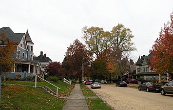
Creighton Avenue, laid out in 1895
-
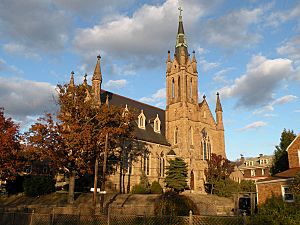
St. Philip Roman Catholic Church, built in 1906
-
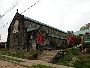
Episcopal Church of the Nativity, built in 1908
-
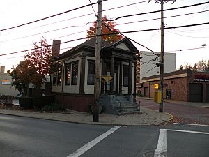
The Campbell Building, around 1910
-
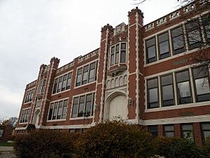
Crafton Elementary School, built in 1913
-
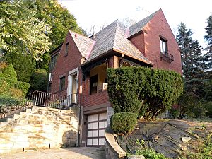
The George Leber House, built in 1938
-
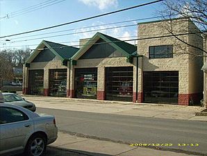
Crafton Volunteer Fire Hall


See also
 In Spanish: Crafton (Pensilvania) para niños
