
McKees Rocks, Pennsylvania facts for kids
Quick facts for kids
McKees Rocks, Pennsylvania
|
|
|---|---|
|
Borough
|
|
.jpg)
View of McKees Rocks, Pennsylvania
|
|
| Etymology: Alexander McKee | |
| Nickname(s):
The Rocks
|
|

Location in Allegheny County and the state of Pennsylvania.
|
|
| Country | |
| State | |
| County | Allegheny |
| Settled in 1764 | Incorporated in 1892 |
| Area | |
| • Total | 1.12 sq mi (2.90 km2) |
| • Land | 1.06 sq mi (2.73 km2) |
| • Water | 0.06 sq mi (0.16 km2) |
| Population
(2020)
|
|
| • Total | 5,920 |
| • Density | 5,606.06/sq mi (2,164.60/km2) |
| Time zone | UTC-5 (EST) |
| • Summer (DST) | UTC-4 (EDT) |
| ZIP code |
15136
|
| Area code(s) | 412 |
| Exchanges | 331, 771, 777, 778 |
| FIPS code | 42-46264 |
| School district | Sto-Rox |
| Website | McKees Rocks |
McKees Rocks, also called "The Rocks", is a small town in Allegheny County, Pennsylvania. It's located right by the Ohio River and is part of the larger Pittsburgh metropolitan area. In 2020, about 5,920 people lived here.
Kids in McKees Rocks go to schools in the Sto-Rox School District. This district also serves the nearby area of Stowe Township. The local high school is Sto-Rox High School.
In an area by the river called "The Bottoms," there used to be a railroad called the Pittsburgh, Allegheny and McKees Rocks Railroad. Today, the Pittsburgh and Ohio Central Railroad is still located there.
The McKees Rocks Bridge connects McKees Rocks to Pittsburgh. It's the longest bridge in Allegheny County, stretching about 7,293 feet (2,223 m). McKees Rocks was also home to one of the biggest ancient mounds in Pennsylvania. It was built by the Adena and Hopewell people over a thousand years ago.
In the past, McKees Rocks was known for its many factories. These included large iron and steel plants. There were also big railroad workshops that made locomotives and freight and passenger cars. Other factories produced things like springs, enamel ware, lumber, and concrete.
McKees Rocks is also famous as the hometown of former Ohio Governor John Kasich and the late TV salesperson Billy Mays.
Contents
History of McKees Rocks
For thousands of years, Native Americans lived in this area. The Adena culture built a large earth mound here, which was used as a burial site. Later, people from the Hopewell culture added to it. This mound is the largest of its kind in Pennsylvania. When people explored it in the late 1800s, they found the remains of 33 individuals inside. The mound is on a high point near the Ohio River, but parts of it have worn away over time.
George Washington once thought about building Fort Pitt at this very spot. However, he eventually decided to build it where the French Fort Duquesne once stood, which is now Point State Park in Pittsburgh.
The town gets its name from a trader named Alexander McKee. He was also an agent who worked with Native American tribes. In 1764, he received a 1,300-acre (530 ha) piece of land for his help during the French and Indian War. The name also refers to a rocky area that sticks out into the river here. In 1769, the name McKees Rocks was officially written on a land deed, and that year is considered the town's founding date. In 1892, it officially became a borough.
The population of McKees Rocks grew a lot in the early 1900s. In 1900, there were 6,353 people. By 1940, the population had reached 17,021. However, as factories closed and jobs were lost, the population started to decrease. By the 2010 census, it was 6,104.
Mann's Hotel was a very old building in McKees Rocks, possibly built around 1803. Some people even thought George Washington might have stayed there. Sadly, the hotel was in very poor condition and had to be taken down in 2009.
McKees Rocks was the site of an important labor strike in 1909. About 5,000 workers from the Pressed Steel Car Company went on strike. They were joined by other workers from nearby towns. The strike was led by the Industrial Workers of the World (IWW). There were conflicts between the workers and security guards, and some people lost their lives.
The town's population was highest in 1930. After that, the Great Depression and changes in industries caused the population to decline. Many people also moved to the suburbs after World War II.
Geography of McKees Rocks
McKees Rocks is located at 40°28′13″N 80°3′49″W / 40.47028°N 80.06361°W.
The borough covers about 1.1 square miles (2.8 km2) in total. Most of this area, about 1.0 square mile (2.6 km2), is land. The rest, about 0.1 square miles (0.26 km2), is water. McKees Rocks has several different neighborhoods, including West Park, Meyers Ridge, and "The Bottoms."
Population Changes in McKees Rocks
| Historical population | |||
|---|---|---|---|
| Census | Pop. | %± | |
| 1890 | 1,687 | — | |
| 1900 | 6,352 | 276.5% | |
| 1910 | 14,702 | 131.5% | |
| 1920 | 16,713 | 13.7% | |
| 1930 | 18,116 | 8.4% | |
| 1940 | 17,021 | −6.0% | |
| 1950 | 16,241 | −4.6% | |
| 1960 | 13,185 | −18.8% | |
| 1970 | 11,901 | −9.7% | |
| 1980 | 8,742 | −26.5% | |
| 1990 | 7,691 | −12.0% | |
| 2000 | 6,622 | −13.9% | |
| 2010 | 6,104 | −7.8% | |
| 2020 | 5,920 | −3.0% | |
| Sources: | |||
In 2000, there were 6,622 people living in McKees Rocks. There were 2,905 households and 1,652 families. The population density was about 6,377.5 inhabitants per square mile (2,462.4/km2).
By the 2010 census, the population was 6,104 residents. The population density was about 6003.25 people per square mile. Most residents were White (62.17%), and a significant number were African American (35.26%).
The average household size was 2.24 people, and the average family size was 2.96 people. About 24.1% of the population was under 18 years old. The median age in the borough was 38 years.
The median income for a household in McKees Rocks was $22,278. For a family, it was $29,063. The average income per person was $13,858. About 25.3% of all people, including 38.8% of those under 18, lived below the poverty line.
Famous People from McKees Rocks


Many interesting people have come from McKees Rocks, including:
- Myron Brown – A basketball star from Slippery Rock University who played in the NBA.
- Tom Clements – A Canadian Football League quarterback and later a coach for the Green Bay Packers.
- Merle Fainsod – A political scientist who taught at Harvard University.
- Chuck Fusina – A football player for Penn State and the NFL.
- Damar Hamlin – An NFL player for the Buffalo Bills.
- John Kasich – The 69th Governor of Ohio and a former Congressman.
- Catherine Baker Knoll – The 30th Lieutenant Governor of Pennsylvania.
- Al Kozar – A Major League Baseball infielder.
- Ted Kwalick – A Penn State football player and NFL tight end, in the College Football Hall of Fame.
- Billy Mays – A famous television salesperson known for his commercials.
- Roman Macek – A former American football player and pro wrestler known as Luca Crusifino.
- Alex Sandusky – A professional football player.
- Jeff Smith – A cartoonist, creator of the Bone comic book series.
- Paul Spadafora – A former boxing champion, known as the "Pittsburgh Kid."
- Olive Thomas – A silent film actress and fashion icon.
Gallery
-
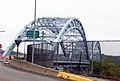
The McKees Rocks Bridge from Island Avenue
-
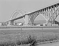
Another view of the McKees Rocks Bridge
-
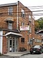
Mancini's Bakery (since 1926)
-
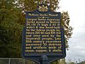
McKees Rocks Mound historical marker
-
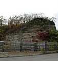
"The Rocks" of McKees Rocks
-
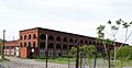
Pittsburgh and Lake Erie Railroad Locomotive Shops


See also
 In Spanish: McKees Rocks para niños
