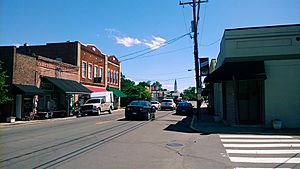
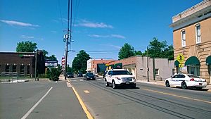
Creedmoor, North Carolina facts for kids
Quick facts for kids
Creedmoor, North Carolina
|
|
|---|---|
 |
|
| Nickname(s):
Mule Town
|
|

Location of Creedmoor, North Carolina
|
|
| Country | United States |
| State | North Carolina |
| County | Granville |
| Founded | April 10, 1885 |
| Incorporated | 1905 |
| Area | |
| • Total | 5.59 sq mi (14.48 km2) |
| • Land | 5.35 sq mi (13.85 km2) |
| • Water | 0.24 sq mi (0.63 km2) |
| Elevation | 354 ft (108 m) |
| Population
(2020)
|
|
| • Total | 4,866 |
| • Density | 910.21/sq mi (351.44/km2) |
| Time zone | UTC-5 (Eastern (EST)) |
| • Summer (DST) | UTC-4 (EDT) |
| ZIP codes |
27522, 27564
|
| Area code(s) | 919 |
| FIPS code | 37-15320 |
| GNIS feature ID | 2404147 |
Creedmoor is a city located in Granville County, North Carolina, United States. In 2020, about 4,866 people lived there. The city is known for its history, especially its connection to railroads.
Contents
History of Creedmoor
Creedmoor began in 1885. A group of 25 local taxpayers, including Civil War veteran Robert Fleming, asked for a railroad to be built. They wanted to invest $10,000 in the Oxford and Clarksville Railroad Company. This idea was approved, and an election was held in October 1887.
For a few years, Creedmoor was an important railroad stop. It connected the Clarksville and Oxford Railroad with the Raleigh and Gaston Railroad. In 1886, Thomas B. Lyon asked for a post office to be opened in Creedmoor. His request was granted on April 10, 1886, and John Harmon became the first postmaster.
Creedmoor officially became a town in 1905. Before that, it was sometimes called "Creedmore." Joseph L. Peed was the first mayor. In 1888, Thomas Lyon sold land for the Durham and Northern Railroad to pass through the town. This new railway linked Creedmoor to Henderson and Durham, which helped the town grow a lot. The old Seaboard train station building is still standing on Elm Street today.
The first First Baptist Church of Creedmoor was built on Elm Street in 1895. The current church building, built in 1950, is on Main Street. Thomas Lyon is buried at the church's original cemetery. Robert Fleming, the founder, is buried in a small family plot on Fleming Street, which is named after him. In 1917, Creedmoor got electricity for the first time.
Creedmoor has a rich history with four buildings listed on the National Register of Historic Places. However, it is not a full "Historic District" like nearby Oxford or Wake Forest.
Historic Places to See
Creedmoor is home to four buildings that are listed on the National Register of Historic Places. These places are important because they show the history of the area.
- Cannady-Brogden Farm (south of Creedmoor)
- James Mangum House
- First National Bank Building
- Obediah Winston Farm
Education in Creedmoor
Creedmoor has several schools that serve students from elementary to high school.
Creedmoor High School first opened in 1909. It was located at the corner of Main Street and Highway 56. Joel Anderson Pitts was the first principal. This school taught students from first to twelfth grade until 1963. After that, white students began attending South Granville High School. The original Creedmoor School building, which then served grades one through eight, unfortunately burned down in 1970.
Today, Creedmoor is home to:
- South Granville High School
- G.C. Hawley Middle School
- Creedmoor Elementary School of the Arts
- Mount Energy Elementary
- South Granville High School of Integrated Technology and Leadership
- South Granville High School of Health and Life Sciences
- Granville Early College High School
The Hawley School was built in 1937 and named after Rev. Grover Cleveland Hawley. It originally served local Black students. Dr. R.G. Rogers, a local doctor and dentist, helped a lot to get the school built. The new Hawley School opened its doors in 1952 for Black students in grades seven through twelve. In 1975, Hawley became a middle school. It now teaches grades six through eight for students from the Creedmoor and Wilton areas.
Other Interesting Places
- Dr. Joseph Thompson House: This house at 213 S. Main Street belonged to the town's first doctor. It was built in 1910 and has a unique design with a wrap-around porch. Dr. Thompson practiced medicine here from about 1908 until 1957.
- Cedar Creek Gallery: This art gallery was built in 1968 on what used to be a tobacco field. It has grown from one building to more than ten.
- Creedmoor Cemetery: Located next to Creedmoor Elementary, this cemetery is the resting place for many important people from Creedmoor's early days. You can find the families of Rogers, Chappell, Lyon, Peed, and others buried here.
Media in Creedmoor
Creedmoor has access to various types of media, including local newspapers, radio stations, and TV channels.
Newspapers
- The Butner-Creedmoor News - This is the local newspaper, started in 1965.
Other newspapers available in the city include:
- The Herald-Sun (from Durham)
- The News & Observer (from Raleigh)
- The Oxford Ledger
- The Franklin Times
Radio Stations
- WCMC-FM 99.9 FM - The Fan (Sports)
- W256AH 99.1 FM (WRTP) - Christian Contemporary music
- WDRU 1030 AM - Religious programs
Local TV Stations
- WTVD - ABC - Durham/Raleigh, NC
- WRAL-TV - NBC - Raleigh, NC
- WRAZ (TV) - Fox - Raleigh/Durham/Fayetteville, NC
- WNCN - CBS - Raleigh/Durham/Goldsboro, NC
- WLFL - The CW - Raleigh/Durham/Fayetteville, NC
- WRDC - MyNetworkTV - Raleigh/Durham/Fayetteville, NC
- WUNC-TV PBS - Chapel Hill
Geography and Location
Creedmoor is in the southern part of Granville County. It is next to the town of Butner on its west side.
U.S. Route 15 goes through Creedmoor and is called Durham Avenue. If you go north on US 15, it's about 14 miles to Oxford, which is the main town of Granville County. If you go southwest, it's about 16 miles to Durham. North Carolina Highway 56 crosses US 15 near the center of town.
Creedmoor covers an area of about 5.59 square miles (14.48 square kilometers). Most of this area is land, with a small part being water.
Lake Rogers is a 175-acre lake in the northwest part of the city. It's a great place for picnics, fishing, and boating. Creedmoor is also part of the Neuse River watershed, which means its water flows into the Neuse River.
Population Information
| Historical population | |||
|---|---|---|---|
| Census | Pop. | %± | |
| 1910 | 324 | — | |
| 1920 | 392 | 21.0% | |
| 1930 | 388 | −1.0% | |
| 1940 | 640 | 64.9% | |
| 1950 | 852 | 33.1% | |
| 1960 | 862 | 1.2% | |
| 1970 | 1,405 | 63.0% | |
| 1980 | 1,641 | 16.8% | |
| 1990 | 1,504 | −8.3% | |
| 2000 | 2,232 | 48.4% | |
| 2010 | 4,124 | 84.8% | |
| 2020 | 4,866 | 18.0% | |
| U.S. Decennial Census | |||
2020 Census Details
| Race | Number | Percentage |
|---|---|---|
| White (non-Hispanic) | 2,271 | 46.67% |
| Black or African American (non-Hispanic) | 1,809 | 37.18% |
| Native American | 16 | 0.33% |
| Asian | 61 | 1.25% |
| Other/Mixed | 245 | 5.03% |
| Hispanic or Latino | 464 | 9.54% |
According to the 2020 United States census, there were 4,866 people living in Creedmoor. There were 1,669 households and 1,291 families.
2010 Census Details
In 2010, Creedmoor had a population of 4,124 people. The city had 1,550 households. About 37.2% of these households had children under 18 living with them. The average household had 2.66 people.
The population was spread out by age. About 27.3% were under 18 years old. About 10.5% were 65 years or older. For every 100 females, there were about 91.8 males.
The average income for a household in the city was $60,417.
See also
 In Spanish: Creedmoor (Carolina del Norte) para niños
 | George Robert Carruthers |
 | Patricia Bath |
 | Jan Ernst Matzeliger |
 | Alexander Miles |


