Crisp County, Georgia facts for kids
Quick facts for kids
Crisp County
|
|
|---|---|

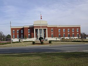
Crisp County Courthouse in Cordele
|
|

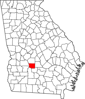
Location within the U.S. state of Georgia
|
|
 Georgia's location within the U.S. |
|
| Country | |
| State | |
| Founded | 1905 |
| Named for | Charles Frederick Crisp |
| Seat | Cordele |
| Largest city | Cordele |
| Area | |
| • Total | 281 sq mi (730 km2) |
| • Land | 273 sq mi (710 km2) |
| • Water | 8.4 sq mi (22 km2) 3.0%% |
| Population
(2020)
|
|
| • Total | 20,128 |
| • Density | 74/sq mi (29/km2) |
| Time zone | UTC−5 (Eastern) |
| • Summer (DST) | UTC−4 (EDT) |
| Congressional district | 2nd |
Crisp County is a special area in the middle part of Georgia. It is like a local government division. In 2020, about 20,128 people lived here. The main town, or county seat, is Cordele.
Crisp County was created on August 17, 1905. It was formed from a part of Dooly County. The county is named after Charles Frederick Crisp. He was a important person from Georgia who worked in the U.S. Congress.
Crisp County is also part of the Cordele, GA micropolitan area. This means it's a smaller city area that is important for jobs and business in the region.
Contents
Exploring Crisp County's Land and Rivers
Crisp County covers a total area of 281 square miles. Most of this area, about 273 square miles, is land. The rest, about 8.4 square miles, is water.
The western part of Crisp County is in the Middle Flint River area. This river basin is part of a larger system called the ACF River Basin. The eastern part of the county is in the Alapaha River area. This river flows into the Suwannee River.
Main Roads in Crisp County
Many important roads run through Crisp County. These roads help people travel and move goods around.
Neighboring Counties
Crisp County shares its borders with several other counties:
- Dooly County (to the north)
- Wilcox County (to the east)
- Turner County (to the southeast)
- Worth County (to the southwest)
- Lee County (to the west)
- Sumter County (to the west)
Towns and Communities
Crisp County has a main city and a town, along with other smaller communities.
City
- Cordele (This is the largest city and the county seat.)
Town
Unincorporated Community
- Coney
People of Crisp County
The number of people living in Crisp County has changed over the years. Here's how the population has grown and shrunk since 1910:
| Historical population | |||
|---|---|---|---|
| Census | Pop. | %± | |
| 1910 | 16,423 | — | |
| 1920 | 18,914 | 15.2% | |
| 1930 | 17,343 | −8.3% | |
| 1940 | 17,540 | 1.1% | |
| 1950 | 17,663 | 0.7% | |
| 1960 | 17,768 | 0.6% | |
| 1970 | 18,087 | 1.8% | |
| 1980 | 19,489 | 7.8% | |
| 1990 | 20,011 | 2.7% | |
| 2000 | 21,996 | 9.9% | |
| 2010 | 23,439 | 6.6% | |
| 2020 | 20,128 | −14.1% | |
| 2023 (est.) | 19,631 | −16.2% | |
| U.S. Decennial Census 1790-18801890-1910 1920-1930 1930-1940 1940-1950 1960-1980 1980-2000 2010 |
|||
In 2020, there were 20,128 people living in Crisp County. These people lived in 8,585 households. About 5,712 of these households were families.
The people in Crisp County come from many different backgrounds. In 2020, about 49% of the people were White (not Hispanic). About 44% were Black or African American (not Hispanic). There were also smaller groups of Asian, Native American, and Pacific Islander people. About 3% of the people were Hispanic or Latino.
Schools and Learning
To learn more about the schools in Crisp County, you can check out the education section for Cordele.
See also
 In Spanish: Condado de Crisp para niños
 | Janet Taylor Pickett |
 | Synthia Saint James |
 | Howardena Pindell |
 | Faith Ringgold |

