Croydon, Pennsylvania facts for kids
Quick facts for kids
Croydon
|
|
|---|---|

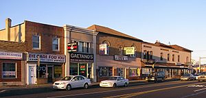
Downtown Croydon, Pennsylvania
|
|
| Country | United States of America |
| State | Pennsylvania |
| County | Bucks |
| Township | Bristol |
| Area | |
| • Total | 2.69 sq mi (6.95 km2) |
| • Land | 2.48 sq mi (6.42 km2) |
| • Water | 0.21 sq mi (0.54 km2) |
| Elevation | 20 ft (6 m) |
| Population
(2020)
|
|
| • Total | 10,014 |
| • Density | 4,041.16/sq mi (1,560.13/km2) |
| Time zone | UTC-5 (EST) |
| • Summer (DST) | UTC-4 (EDT) |
| ZIP code |
19021
|
| Area codes | 215, 267, and 445 |
| FIPS code | 42-17448 |
Croydon is a community in Bristol Township, Bucks County, Pennsylvania, United States. It is known as a census-designated place, which means it's an area identified by the U.S. Census Bureau for statistical purposes. In 2010, about 9,950 people lived there.
Croydon is located in southeastern Pennsylvania. It is about 68.9 miles (110.9 km) southeast of Allentown. It is also about 18.5 miles (29.8 km) northeast of Philadelphia.
Contents
History of Croydon
The name Croydon comes from a town in South-East England. That town, also called Croydon, is about nine miles south of the center of London. It was once part of Surrey county.
An important historical building in the area is the White Hall of Bristol College. This building was added to the National Register of Historic Places in 1984. This list helps protect important historical sites.
Geography and Climate
Croydon is located at coordinates 40°5′26″N 74°53′57″W. The community covers an area of about 6.4 square kilometers (2.5 sq mi). All of this area is land.
Rivers and Waterways
Croydon is bordered by water on two sides. To the south, you'll find Neshaminy Creek. This creek is tidal, meaning its water level changes with the ocean's tides. Small boats can travel on it. There are several private boat docks, and a public marina at Neshaminy State Park.
The Neshaminy Creek flows into the Delaware River. The Delaware River borders Croydon to the east. This river also forms the border between Pennsylvania and New Jersey. The Delaware River here is also tidal. Large ocean-going ships can travel on it as far north as Trenton, New Jersey.
Local Climate
Croydon has a humid subtropical climate. This means it has hot, humid summers and mild winters. The average temperature in January is about 32.8°F (0.4°C). In July, the average temperature is around 76.6°F (24.8°C). The area is in a plant hardiness zone called 7a. This zone helps gardeners know which plants can survive the winter temperatures.
Population Information
| Historical population | |||
|---|---|---|---|
| Census | Pop. | %± | |
| 1990 | 9,967 | — | |
| 2000 | 9,993 | 0.3% | |
| 2010 | 9,950 | −0.4% | |
| 2020 | 10,014 | 0.6% | |
In 2010, the population of Croydon was 9,950 people. The most recent census in 2020 showed the population grew slightly to 10,014 people.
The people living in Croydon come from many different backgrounds. In 2010, most residents were White (82.9%). Other groups included Black or African American (4.8%), Asian (2.9%), and Native American (0.2%). About 7.4% of the population had Hispanic or Latino family roots.
Education
Croydon has had different schools over the years. In 2011, the Roman Catholic Archdiocese of Philadelphia announced that St. Thomas Aquinas School would close. This decision was made because the number of students attending the school had become too low.
See also
 In Spanish: Croydon (Pensilvania) para niños
 | James Van Der Zee |
 | Alma Thomas |
 | Ellis Wilson |
 | Margaret Taylor-Burroughs |


