Cumaribo facts for kids
Quick facts for kids
Cumaribo
|
|||
|---|---|---|---|
|
town
|
|||
|
|||

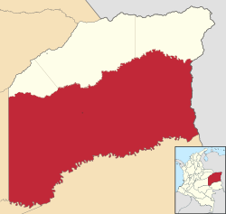
Location of Cumaribo in Vichada
|
|||
| Country | Colombia | ||
| Region | Orinoquía | ||
| Department | Vichada | ||
| Foundation | 1959 | ||
| Area | |||
| • Total | 65,193 km2 (25,171 sq mi) | ||
| Population
(2010)
|
|||
| • Total | 23,990 | ||
| • Density | 0.36798/km2 (0.95307/sq mi) | ||
| Time zone | UTC-5 | ||
| Postal code |
991001
|
||
| Demonym | cumaribense | ||
| Climate | Am | ||
| Website | cumaribo-vichada.gov.co/ |
||
| * | |||
Cumaribo is a town and a large area of land (called a municipality) in the Department of Vichada, Colombia. It was started by Jose Nicolino Mattar in 1959.
Cumaribo is special because it is the biggest municipality in Colombia by size. It covers about 65,193 square kilometers! In 2005, around 28,718 people lived there. About 4,312 of these people lived in the main town area.
Contents
Geography
The municipality of Cumaribo is located in a very interesting part of Colombia.
- To the north, it shares borders with three other towns in Vichada: La Primavera, Puerto Carreño, and Santa Rosalia.
- To the east, it borders Venezuela.
- To the south, it meets the Department of Guainía.
- To the west, it borders the departments of Meta and Guaviare.
Cumaribo is part of the Orinoquia Region of Colombia. This area is mostly flat plains called the Llanos. These plains stretch across parts of Colombia and Venezuela. Most of Cumaribo (about three-quarters) is savanna, which is like a grassy plain with scattered trees. The rest of the area is covered by thick jungle. There are also some small mountains, including Mount Vichada, Mount Mona, Mount Matavenia, and Mount Guaripa.
Three big rivers flow through or near Cumaribo: the Orinoco River, the Meta River, and the Guaviare River. The Meta River flows into the Orinoco. The Guaviare River is important for other rivers like the Muro, Uva, and Mataven. Cumaribo also has two main lakes: Lake Caimán and Lake Sesema.
Climate
Cumaribo has a tropical monsoon climate. This means it's very warm or hot all year round, usually between 27 and 30 degrees Celsius (81 to 86 degrees Fahrenheit). It's also very humid. There is a lot of rain for most of the year, especially from April to November. January and February are usually the driest months.
| Climate data for Cumaribo (Gaviotas Las), elevation 171 m (561 ft), (1981–2010) | |||||||||||||
|---|---|---|---|---|---|---|---|---|---|---|---|---|---|
| Month | Jan | Feb | Mar | Apr | May | Jun | Jul | Aug | Sep | Oct | Nov | Dec | Year |
| Mean daily maximum °C (°F) | 33.0 (91.4) |
33.8 (92.8) |
33.6 (92.5) |
31.7 (89.1) |
30.4 (86.7) |
29.5 (85.1) |
29.4 (84.9) |
30.3 (86.5) |
31.2 (88.2) |
31.5 (88.7) |
31.4 (88.5) |
31.7 (89.1) |
31.5 (88.7) |
| Daily mean °C (°F) | 27.3 (81.1) |
27.8 (82.0) |
27.6 (81.7) |
26.3 (79.3) |
25.6 (78.1) |
25.0 (77.0) |
24.6 (76.3) |
25.1 (77.2) |
25.6 (78.1) |
25.9 (78.6) |
26.1 (79.0) |
26.4 (79.5) |
26.1 (79.0) |
| Mean daily minimum °C (°F) | 21.2 (70.2) |
21.8 (71.2) |
22.3 (72.1) |
22.7 (72.9) |
22.6 (72.7) |
22.1 (71.8) |
21.7 (71.1) |
21.8 (71.2) |
22.1 (71.8) |
22.3 (72.1) |
22.4 (72.3) |
22.0 (71.6) |
22.1 (71.8) |
| Average precipitation mm (inches) | 33.7 (1.33) |
57.9 (2.28) |
123.1 (4.85) |
307.3 (12.10) |
377.3 (14.85) |
420.4 (16.55) |
365.8 (14.40) |
292.4 (11.51) |
277.6 (10.93) |
253.1 (9.96) |
226.2 (8.91) |
101.4 (3.99) |
2,836.4 (111.67) |
| Average precipitation days | 4 | 6 | 9 | 19 | 24 | 25 | 25 | 23 | 20 | 20 | 16 | 9 | 197 |
| Average relative humidity (%) | 67 | 66 | 71 | 82 | 87 | 88 | 87 | 86 | 85 | 84 | 83 | 77 | 80 |
| Mean monthly sunshine hours | 254.2 | 203.3 | 167.4 | 132.0 | 117.8 | 111.0 | 120.9 | 130.2 | 150.0 | 164.3 | 171.0 | 217.0 | 1,939.1 |
| Mean daily sunshine hours | 8.2 | 7.2 | 5.4 | 4.4 | 3.8 | 3.7 | 3.9 | 4.2 | 5.0 | 5.3 | 5.7 | 7.0 | 5.3 |
| Source: Instituto de Hidrologia Meteorologia y Estudios Ambientales | |||||||||||||
| Climate data for Cumaribo (Tapon El), elevation 315 m (1,033 ft), (1981–2010) | |||||||||||||
|---|---|---|---|---|---|---|---|---|---|---|---|---|---|
| Month | Jan | Feb | Mar | Apr | May | Jun | Jul | Aug | Sep | Oct | Nov | Dec | Year |
| Mean daily maximum °C (°F) | 34.1 (93.4) |
34.4 (93.9) |
34.5 (94.1) |
32.3 (90.1) |
31.1 (88.0) |
30.2 (86.4) |
29.9 (85.8) |
30.7 (87.3) |
31.7 (89.1) |
32.1 (89.8) |
32.5 (90.5) |
33.2 (91.8) |
32.2 (90.0) |
| Daily mean °C (°F) | 27.8 (82.0) |
28.2 (82.8) |
28.0 (82.4) |
26.8 (80.2) |
26.0 (78.8) |
25.5 (77.9) |
25.0 (77.0) |
25.4 (77.7) |
26.0 (78.8) |
26.3 (79.3) |
26.6 (79.9) |
27.1 (80.8) |
26.5 (79.7) |
| Mean daily minimum °C (°F) | 21.6 (70.9) |
21.9 (71.4) |
22.3 (72.1) |
22.6 (72.7) |
22.4 (72.3) |
21.8 (71.2) |
21.4 (70.5) |
21.9 (71.4) |
22.0 (71.6) |
22.2 (72.0) |
22.1 (71.8) |
22.1 (71.8) |
22.0 (71.6) |
| Average precipitation mm (inches) | 33.2 (1.31) |
81.6 (3.21) |
108.8 (4.28) |
232.6 (9.16) |
358.5 (14.11) |
423.4 (16.67) |
406.0 (15.98) |
356.9 (14.05) |
304.1 (11.97) |
291.4 (11.47) |
216.7 (8.53) |
93.5 (3.68) |
2,906.9 (114.44) |
| Average precipitation days | 4 | 6 | 8 | 15 | 20 | 21 | 22 | 20 | 17 | 16 | 13 | 9 | 165 |
| Mean monthly sunshine hours | 248.0 | 208.9 | 195.3 | 141.0 | 114.7 | 114.0 | 120.9 | 130.2 | 147.0 | 158.1 | 183.0 | 220.1 | 1,981.2 |
| Mean daily sunshine hours | 8.0 | 7.4 | 6.3 | 4.7 | 3.7 | 3.8 | 3.9 | 4.2 | 4.9 | 5.1 | 6.1 | 7.1 | 5.4 |
| Source: Instituto de Hidrologia Meteorologia y Estudios Ambientales | |||||||||||||
| Climate data for Cumaribo (Tuparro Bocas Tomo), elevation 250 m (820 ft), (1981–2010) | |||||||||||||
|---|---|---|---|---|---|---|---|---|---|---|---|---|---|
| Month | Jan | Feb | Mar | Apr | May | Jun | Jul | Aug | Sep | Oct | Nov | Dec | Year |
| Mean daily maximum °C (°F) | 35.0 (95.0) |
35.0 (95.0) |
34.9 (94.8) |
33.1 (91.6) |
32.0 (89.6) |
31.0 (87.8) |
30.6 (87.1) |
31.4 (88.5) |
31.9 (89.4) |
33.2 (91.8) |
33.2 (91.8) |
34.0 (93.2) |
32.8 (91.0) |
| Daily mean °C (°F) | 28.5 (83.3) |
28.8 (83.8) |
29.0 (84.2) |
27.9 (82.2) |
26.9 (80.4) |
26.2 (79.2) |
26.0 (78.8) |
26.5 (79.7) |
26.9 (80.4) |
27.3 (81.1) |
27.6 (81.7) |
27.9 (82.2) |
27.5 (81.5) |
| Mean daily minimum °C (°F) | 22.7 (72.9) |
22.3 (72.1) |
23.6 (74.5) |
23.2 (73.8) |
22.7 (72.9) |
22.0 (71.6) |
22.1 (71.8) |
22.2 (72.0) |
22.9 (73.2) |
22.5 (72.5) |
22.6 (72.7) |
21.5 (70.7) |
22.5 (72.5) |
| Average precipitation mm (inches) | 43.8 (1.72) |
45.9 (1.81) |
81.1 (3.19) |
200.4 (7.89) |
354.8 (13.97) |
456.7 (17.98) |
465.3 (18.32) |
323.1 (12.72) |
222.2 (8.75) |
209.7 (8.26) |
173.6 (6.83) |
76.2 (3.00) |
2,652.8 (104.44) |
| Average precipitation days | 4 | 5 | 7 | 12 | 20 | 21 | 23 | 19 | 15 | 16 | 13 | 7 | 154 |
| Average relative humidity (%) | 73 | 73 | 72 | 82 | 86 | 87 | 86 | 85 | 85 | 84 | 82 | 79 | 81 |
| Mean monthly sunshine hours | 257.3 | 223.0 | 207.7 | 156.0 | 139.5 | 117.0 | 136.4 | 155.0 | 159.0 | 186.0 | 198.0 | 244.9 | 2,179.8 |
| Mean daily sunshine hours | 8.3 | 7.9 | 6.7 | 5.2 | 4.5 | 3.9 | 4.4 | 5.0 | 5.3 | 6.0 | 6.6 | 7.9 | 6.0 |
| Source: Instituto de Hidrologia Meteorologia y Estudios Ambientales | |||||||||||||
History
Cumaribo was officially founded in 1959 by a group of settlers led by Jose Nicolino Mattar. However, people lived in this area long before that. Indigenous groups, like the Guahibo, were the first inhabitants of this land.
Challenges in the Region
The Cumaribo area has faced some challenges over the years. Because it's a large area that can be hard to reach, there have been efforts to ensure peace and safety for everyone living there. The government and local communities work together to bring stability and development to the region.
Demography
In 2001, a count of the population in the main town of Cumaribo showed there were 1,055 people. About half were male (534) and half were female (521).
- Children (0-14 years old): 418 people.
- Young adults (15-24 years old): 208 people.
- Adults (25-49 years old): 358 people.
- People 49 and older: 71 people.
More than half of the people living in Cumaribo were settlers who moved there. About 35% of the population were indigenous people, and 15% were mestizos (people of mixed European and indigenous heritage).
Indigenous Reserves in Cumaribo
Cumaribo is home to many indigenous communities. There are about 38 special areas called indigenous reserves. These are lands set aside for indigenous peoples to live according to their traditions and culture.
The main indigenous groups in Cumaribo include:
- The Guahibo people
- The Curripaco
- The Piapoco (these three groups speak languages from the Arawak language family)
- The Cuiva
- The Desana
- The Puinave
- The Saliva
Here is a list of some of the indigenous reserves in Cumaribo:
- Santa Teresita del Tuparro
- Tomo Bebery
- El Merey
- San Luis del Tomo
- La Esmeralda
- Valdivia
- Tsololoibo Matatu
- Muco Guarrojo
- Rawaneruba
- Saracure
- Únuma
- Concordia
- Barranco Lindo
- Corocora
- Palomas Carpintero
- Guaco
- Chocón
- Laguna Colorada
- Cali
- Minitas
- Morocoto-Buenavista-Manajuare
- Giro
- Yurí
- Cumaral
- Barranquito – Laguna Colorada
- Caño Bocón
- Laguna Anguilla – La Macarena
- Sejalito – San Benito
- Lagunas Negra y Cacao
- Berrocal – Ajota
- Matavén – Fruta
- Caño Zama
- Atana Pirariame
- Equa Guarracañá
- Bajo Vichada
- Aiwa Cuna Tsepajibo
- Caño Cavasi
- Guacamayas.
See also
 In Spanish: Cumaribo para niños
 | May Edward Chinn |
 | Rebecca Cole |
 | Alexa Canady |
 | Dorothy Lavinia Brown |


