Puerto Carreño facts for kids
Quick facts for kids
Puerto Carreno
Picacho del Orinoco
|
|||
|---|---|---|---|
|
Consolidated Capital City | Municipality
|
|||
| Puerto Carreño | |||
|
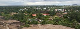
From the top: Puerto Carreño skyline panorama, street in the city, statues of Indigenous peoples near docks, Orinoco River beach and a discoteque/restaurant floating on the Orinoco.
|
|||
|
|||
| Nickname(s):
Capital of Indigenous Artisans
|
|||

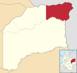
Location of the capital city and municipality of Puerto Carreño in the Department of Vichada.
|
|||
| Country | |||
| Region | Orinoquía | ||
| Department | Department of Vichada | ||
| Foundation | 1913 | ||
| Named for | Pedro María Carreño, Commissioner 1912 | ||
| Area | |||
| • Consolidated Capital City | Municipality | 12,409 km2 (4,791 sq mi) | ||
| • Urban | 7.5 km2 (2.9 sq mi) | ||
| • Metro | 22.5 km2 (8.7 sq mi) | ||
| Elevation | 51 m (167 ft) | ||
| Population
(2018)
|
|||
| • Consolidated Capital City | Municipality | 20,936 | ||
| • Estimate
(2023)
|
22,500 | ||
| • Density | 1.68716/km2 (4.36973/sq mi) | ||
| • Urban | 12,897 | ||
| • Metro | 14,974 | ||
| Demonym(s) | Carreñense | ||
| Time zone | UTC−5 (COT) | ||
| Climate | Am | ||
| Website | Government Tourism Council |
||
Puerto Carreño is a city in Colombia. It is the capital of the Vichada area. This city is located in the Llanos region, right on the Orinoco River.
Puerto Carreño is a popular place for tourists. It offers many adventure and nature-friendly trips. People also know it for:
- Fishing for peacock bass in the Vita River.
- Beautiful crafts made by Indigenous artists from the Orinoquia region.
- Being a busy river port for trade.
- Being a border town that became the capital of Colombia's second-largest department.
The city is also famous for having many trees. It grows a lot of marañon fruit (which is a type of cashew). You can find over a dozen different kinds of mango trees within the city!
Contents
History of Puerto Carreño
In 1913, the Colombian government created a new area called Vichada. They decided its capital would be where the Orinoco and Meta rivers meet. This spot was a small village known as El Picacho del Orinoco.
In 1934, "El Picacho" was officially renamed Puerto Carreño. It was named after Pedro María Carreño. He was Colombia's Minister of External Relations from 1912 to 1913.
The area became a "municipio" (like a county) in 1974. On July 5, 1991, Vichada became a "departamento" (a larger region). Puerto Carreño was then confirmed as its capital.
The Colombian government's statistics office (DANE) estimated the city's population to be about 10,034 in 2005. This was based on a count from 1993. Many Indigenous groups live in the Puerto Carreño area. About 54% of the local people are Indigenous.
Geography of Puerto Carreño
The city of Puerto Carreño is in the far northeastern part of the Vichada Department. It shares borders with Venezuela to the north and east. The Meta and Orinoco rivers form these borders. To the south, Puerto Carreño borders the city of Cumaribo. To the west, it borders La Primavera.
The land in this area is mostly flat. There is a small rise in the town itself, which gave it its first name. The weather is hot and humid. The average temperature is about 28°C (82°F). There is a heavy rainy season from April to September.
The area is part of the llanos plains. These plains cover large parts of Colombia and Venezuela. They are rich in many different kinds of plants and animals. Puerto Carreño is on the Guiana Shield. This area is mostly made of old rock formations. There are also some low mountains, like the Mounts of Casuarito and the Hormiga and Guaripa mountains.
Economy of Puerto Carreño
The main ways people make money in Puerto Carreño are through:
- Farming and raising animals.
- Tourism.
- Fishing.
- Mining.
There is also some trade with towns in Venezuelan across the Orinoco River. Puerto Carreño often trades with Puerto Páez in Venezuela. The main products grown in the region are rice, yuca (cassava), and plantain.
People enjoy sportfishing on private farms. Some large farms have become tourist spots for farming tourism and nature tourism. There are also mines for gold, coltan, and silver. These are often mined using simple methods.
Tourism in Puerto Carreño
Puerto Carreño is a small town. It is a starting point for trips to other places. It is also a border outpost and a river port city. But Puerto Carreño has also become a popular tourist spot on its own. It has more and more attractions, local parties, and yearly events.
Visitors from other countries can eat three meals a day and stay in a nice hotel room for less than $50 a day (in 2023). Many choose creative nature tours. These tours cost less than $250 USD per day. They are designed to be good for the environment and local people. About 30% to 60% of the money from these tours goes back to help Indigenous communities. It also helps improve tourism facilities and farming programs. This means that when you visit, you are helping the local community.
The Germán Olano Airport is being updated. It should be finished by the end of 2023. This will help tourism in Puerto Carreño. It will make the city a place for adventurous travelers to start their trips. It will also be good for people looking for a budget-friendly vacation or a complete escape from city life.
Climate
Puerto Carreño has a tropical monsoon climate. This means it has a very hot and dry season from December to March. It then has a hot and very humid wet season from April to November.
| Climate data for Puerto Carreño (Germán Olano Airport), elevation 50 m (160 ft), (1981–2010) | |||||||||||||
|---|---|---|---|---|---|---|---|---|---|---|---|---|---|
| Month | Jan | Feb | Mar | Apr | May | Jun | Jul | Aug | Sep | Oct | Nov | Dec | Year |
| Mean daily maximum °C (°F) | 34.8 (94.6) |
35.7 (96.3) |
36.1 (97.0) |
34.3 (93.7) |
32.2 (90.0) |
31.0 (87.8) |
30.7 (87.3) |
31.4 (88.5) |
32.4 (90.3) |
33.3 (91.9) |
33.5 (92.3) |
33.8 (92.8) |
33.3 (91.9) |
| Daily mean °C (°F) | 29.5 (85.1) |
30.4 (86.7) |
30.9 (87.6) |
29.5 (85.1) |
27.8 (82.0) |
26.8 (80.2) |
26.6 (79.9) |
26.9 (80.4) |
27.5 (81.5) |
28.1 (82.6) |
28.5 (83.3) |
28.9 (84.0) |
28.5 (83.3) |
| Mean daily minimum °C (°F) | 23.2 (73.8) |
23.9 (75.0) |
24.7 (76.5) |
24.6 (76.3) |
24.1 (75.4) |
23.4 (74.1) |
23.2 (73.8) |
23.4 (74.1) |
23.7 (74.7) |
23.9 (75.0) |
24.0 (75.2) |
23.7 (74.7) |
23.8 (74.8) |
| Average precipitation mm (inches) | 11.1 (0.44) |
17.0 (0.67) |
45.4 (1.79) |
156.1 (6.15) |
285.3 (11.23) |
466.3 (18.36) |
487.9 (19.21) |
340.9 (13.42) |
208.5 (8.21) |
167.5 (6.59) |
108.8 (4.28) |
33.8 (1.33) |
2,328.8 (91.69) |
| Average precipitation days | 2 | 3 | 5 | 13 | 21 | 25 | 26 | 24 | 19 | 17 | 11 | 5 | 169 |
| Average relative humidity (%) | 62 | 58 | 58 | 67 | 76 | 80 | 80 | 79 | 77 | 75 | 73 | 68 | 71 |
| Mean monthly sunshine hours | 260.4 | 231.5 | 223.2 | 171.0 | 142.6 | 126.0 | 139.5 | 148.8 | 162.0 | 195.3 | 207.0 | 238.7 | 2,246 |
| Mean daily sunshine hours | 8.4 | 8.2 | 7.2 | 5.7 | 4.6 | 4.2 | 4.5 | 4.8 | 5.4 | 6.3 | 6.9 | 7.7 | 6.2 |
| Source: Instituto de Hidrologia Meteorologia y Estudios Ambientales | |||||||||||||
See also
 In Spanish: Puerto Carreño para niños
 | Selma Burke |
 | Pauline Powell Burns |
 | Frederick J. Brown |
 | Robert Blackburn |


