Currie, Tasmania facts for kids
Quick facts for kids CurrieTasmania |
|||||||||||||||
|---|---|---|---|---|---|---|---|---|---|---|---|---|---|---|---|

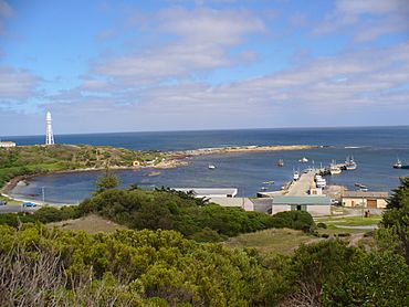
Currie Harbour, 2007
|
|||||||||||||||
| Postcode(s) | 7256 | ||||||||||||||
| LGA(s) | King Island Council | ||||||||||||||
| Region | North-west and west | ||||||||||||||
| State electorate(s) | Braddon | ||||||||||||||
| Federal Division(s) | Braddon | ||||||||||||||
|
|||||||||||||||
Currie is a small town located on King Island in Tasmania, Australia. It's the biggest town on the island and acts as its main hub. In 2021, about 659 people lived there.
Currie is found on the western side of King Island. This island sits at the western entrance to Bass Strait.
A Look Back in Time
Currie wasn't always called Currie! It was first known as Howie's Boat Harbour. This name came from David Howie, who visited the island in the 1840s.
The town got its new name, Currie, from Archibald Currie. He was a ship owner from Melbourne. In 1866, a ship called the Netherby was wrecked nearby. Archibald Currie bought what was left of the ship. He used the harbour as a base to try and save parts of it.
The harbour was also used for other shipwrecks. These included the British Admiral in 1874 and the Blencathra in 1875. The Blencathra actually wrecked right at the harbour's entrance!
To help ships, the Currie Lighthouse was built in 1879.
Soon after, people started farming in the area. They mostly raised beef and dairy cattle. Currie was the main port for King Island. It connected the island to both Victoria and Tasmania. This was true until 1974, when a new port opened at Grassy Harbour.
Currie officially became a "locality" in 1971.
Where is Currie?
Currie is right next to the Southern Ocean. The ocean forms its western and south-western borders.
The town is set a little bit back from a natural harbour. This harbour is partly protected from the ocean. Currie is very important for the fishing industry. Many people there fish for rock lobster.
Close to the town is the King Island Airport. This airport can handle medium-sized planes.
Getting Around
Roads
Route B25 is a main road in Currie. It runs north from the town centre as Main Street. Then it becomes North Road. This road also goes east from the town as Grassy Road.
Airport
The King Island Airport is a commercial airport. It is located very close to Currie. This airport is the main base for King Island Airlines.
Currie's Weather
Currie has a very mild oceanic climate. This means it has cool summers and mild winters. It's almost like a Mediterranean climate because its summers are quite dry.
It hardly ever gets frosty in winter. This is because the ocean keeps the temperatures steady. Only about three days a year will be hotter than 30 degrees Celsius.
Currie is often cloudy and showery. More than half the days get some rain. But the rain is usually not very heavy. The town is also quite windy. The average wind speed is about 21.6 kilometers per hour. Gusts can reach as high as 124 kilometers per hour!
| Climate data for Currie Post Office (1909-1997) | |||||||||||||
|---|---|---|---|---|---|---|---|---|---|---|---|---|---|
| Month | Jan | Feb | Mar | Apr | May | Jun | Jul | Aug | Sep | Oct | Nov | Dec | Year |
| Record high °C (°F) | 38.4 (101.1) |
37.6 (99.7) |
35.0 (95.0) |
30.0 (86.0) |
23.1 (73.6) |
18.6 (65.5) |
18.0 (64.4) |
19.6 (67.3) |
26.5 (79.7) |
29.5 (85.1) |
33.0 (91.4) |
36.0 (96.8) |
38.4 (101.1) |
| Mean daily maximum °C (°F) | 20.3 (68.5) |
20.6 (69.1) |
19.6 (67.3) |
17.2 (63.0) |
15.1 (59.2) |
13.5 (56.3) |
12.9 (55.2) |
13.2 (55.8) |
14.3 (57.7) |
15.6 (60.1) |
17.0 (62.6) |
18.7 (65.7) |
16.5 (61.7) |
| Mean daily minimum °C (°F) | 12.5 (54.5) |
13.1 (55.6) |
12.6 (54.7) |
11.2 (52.2) |
9.8 (49.6) |
8.5 (47.3) |
7.8 (46.0) |
7.8 (46.0) |
8.3 (46.9) |
9.0 (48.2) |
9.9 (49.8) |
11.3 (52.3) |
10.2 (50.4) |
| Record low °C (°F) | 6.4 (43.5) |
7.0 (44.6) |
6.1 (43.0) |
2.0 (35.6) |
1.1 (34.0) |
1.1 (34.0) |
−0.5 (31.1) |
−0.5 (31.1) |
1.7 (35.1) |
0.0 (32.0) |
0.6 (33.1) |
4.6 (40.3) |
−0.5 (31.1) |
| Average rainfall mm (inches) | 35.6 (1.40) |
38.8 (1.53) |
48.0 (1.89) |
67.8 (2.67) |
98.0 (3.86) |
102.4 (4.03) |
124.1 (4.89) |
114.7 (4.52) |
84.2 (3.31) |
74.8 (2.94) |
59.8 (2.35) |
52.3 (2.06) |
900.5 (35.45) |
| Average rainy days (≥ 0.2 mm) | 10.7 | 10.2 | 13.7 | 17.4 | 21.3 | 22.3 | 24.3 | 23.8 | 20.6 | 18.5 | 15.4 | 13.4 | 211.6 |
| Average relative humidity (%) | 67 | 68 | 70 | 75 | 79 | 80 | 79 | 77 | 75 | 74 | 72 | 70 | 74 |
| Source: Bureau of Meteorology | |||||||||||||
 | Anna J. Cooper |
 | Mary McLeod Bethune |
 | Lillie Mae Bradford |


