Cut Bank Creek facts for kids
Quick facts for kids Cut Bank Creek |
|
|---|---|

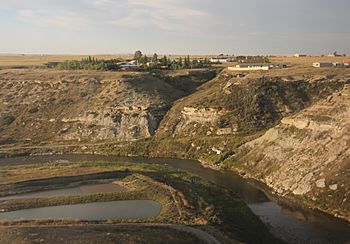
The Cut Bank Creek at Cut Bank, Montana
|
|
| Country | Glacier County, Montana |
| Physical characteristics | |
| Main source | 48°34′55″N 113°07′44″W / 48.58194°N 113.12889°W |
| River mouth | 3,294 feet (1,004 m) 48°29′12″N 112°13′36″W / 48.48667°N 112.22667°W |
| Basin features | |
| River system | Missouri River |
Cut Bank Creek is a cool river in northwestern Montana, USA. It's about 75 miles (123 km) long. This river is special because it has carved out really deep, steep banks. These banks are so famous that they gave the name "cut bank" to a type of landform in geology!
Contents
About Cut Bank Creek
Cut Bank Creek is a tributary of the Marias River. A tributary is a smaller river or stream that flows into a larger river. The Marias River is part of the huge Missouri River system. This means all the water from Cut Bank Creek eventually flows into the Missouri River.
Where Cut Bank Creek Begins
This amazing creek starts high up in the Rocky Mountains. Its journey begins inside Glacier National Park. This area is also home to the continental divide. The continental divide is like a giant line across North America. It separates which ocean rivers will flow into.
The Creek's Journey
From the mountains, Cut Bank Creek flows east and northeast. It then moves onto the foothills and plains. These plains are part of the Blackfeet Indian Reservation. The creek then turns southeast.
It flows past the town of Cut Bank, Montana. Near the town, the creek has carved out a beautiful gorge. A gorge is a deep, narrow valley with steep sides. This gorge is about 150 feet (46 meters) deep!
The Famous Railway Bridge
An elevated railway bridge crosses this deep gorge. It's only about a mile from the town's Amtrak passenger station. The BNSF also has freight yards nearby. The river and its cliffs here are a perfect example of what a "cut bank" looks like. This is why the landform got its name from this very spot!
Where Cut Bank Creek Ends
In southeastern Glacier County, the creek's journey comes to an end. About 12 miles (19 km) southeast of Cut Bank, it joins another river. It meets the Two Medicine River. When these two rivers come together, they form the Marias River.
 | Precious Adams |
 | Lauren Anderson |
 | Janet Collins |

