Cuyuna, Minnesota facts for kids
Quick facts for kids
Cuyuna
|
|
|---|---|

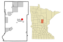
Location of Cuyuna
within Crow Wing County, Minnesota |
|
| Country | United States |
| State | Minnesota |
| County | Crow Wing |
| Area | |
| • Total | 3.38 sq mi (8.75 km2) |
| • Land | 3.23 sq mi (8.38 km2) |
| • Water | 0.14 sq mi (0.37 km2) |
| Elevation | 1,288 ft (393 m) |
| Population
(2020)
|
|
| • Total | 296 |
| • Density | 91.53/sq mi (35.33/km2) |
| Time zone | UTC-6 (Central (CST)) |
| • Summer (DST) | UTC-5 (CDT) |
| ZIP code |
56444
|
| Area code(s) | 218 |
| FIPS code | 27-14428 |
| GNIS feature ID | 2393702 |
| Website | www.ci.cuyuna.mn.us |
Cuyuna (pronounced kye-YOO-nuh) is a small city in Crow Wing County, Minnesota, United States. In 2020, about 296 people lived there. It is part of the Brainerd area.
Cuyuna is located on the Cuyuna Range. This area has hills rich in iron ore. Cuyuna was one of many mining towns here. Other towns included Crosby and Ironton. Mining was very important in the first half of the 1900s. It stopped completely in 1984. Today, Cuyuna is known for tourism. Many people visit for mountain biking. The Cuyuna Country State Recreation Area is a popular spot.
History of Cuyuna
Cuyuna became an official city in 1910. The city and the iron range are named after a man named Cuyler Adams. He was a prospector who found the iron ore. His dog, Una, often went with him on his trips. So, the name "Cuyuna" comes from "Cuyler" and "Una."
Before the city was built, the Rabbit Lake Band of Mississippi Chippewa lived in this area. In 1855, a special agreement set up the Rabbit Lake Indian Reservation. This area included where Cuyuna is now. Later, many members of the Rabbit Lake Band moved to other areas. Some went to Leech Lake and then to the White Earth Indian Reservation. Others joined the Mille Lacs Band of Ojibwe. After they moved, not many people lived here. Then, in 1906, a mining village called Cuyuna started. The town was officially mapped out in November 1908.
Geography
Cuyuna covers about 3.53 square miles (9.14 square kilometers). Most of this area is land, about 3.28 square miles (8.49 square kilometers). The rest is water, about 0.25 square miles (0.65 square kilometers).
A main road in Cuyuna is Crow Wing County Road 31. Other nearby roads include Minnesota State Highway 6 and State Highway 210.
The city is located south of Rabbit Lake. The town of Crosby is about three miles (4.8 kilometers) away. The Cuyuna Country State Recreation Area is also close by.
Population Changes
The number of people living in Cuyuna has changed over the years. Here's a look at the population from different census counts:
| Historical population | |||
|---|---|---|---|
| Census | Pop. | %± | |
| 1920 | 417 | — | |
| 1930 | 266 | −36.2% | |
| 1940 | 176 | −33.8% | |
| 1950 | 112 | −36.4% | |
| 1960 | 86 | −23.2% | |
| 1970 | 82 | −4.7% | |
| 1980 | 157 | 91.5% | |
| 1990 | 172 | 9.6% | |
| 2000 | 231 | 34.3% | |
| 2010 | 332 | 43.7% | |
| 2020 | 296 | −10.8% | |
| U.S. Decennial Census | |||
2010 Census Details
In 2010, there were 332 people living in Cuyuna. There were 126 households, which are groups of people living together. About 31.7% of these households had children under 18. Most residents were White (97.6%).
The average age of people in Cuyuna was 39.5 years old. About 30.1% of the residents were under 18. Also, 14.5% were 65 years old or older. The population was 54.5% male and 45.5% female.
See also
 In Spanish: Cuyuna (Minnesota) para niños
 | DeHart Hubbard |
 | Wilma Rudolph |
 | Jesse Owens |
 | Jackie Joyner-Kersee |
 | Major Taylor |

