Davison County, South Dakota facts for kids
Quick facts for kids
Davison County
|
|
|---|---|

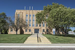
Davison County Courthouse in Mitchell
|
|

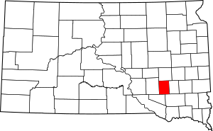
Location within the U.S. state of South Dakota
|
|
 South Dakota's location within the U.S. |
|
| Country | |
| State | |
| Founded | 1873 (created) 1874 (organized) |
| Seat | Mitchell |
| Largest city | Mitchell |
| Area | |
| • Total | 437 sq mi (1,130 km2) |
| • Land | 436 sq mi (1,130 km2) |
| • Water | 1.4 sq mi (4 km2) 0.3% |
| Population
(2020)
|
|
| • Total | 19,956 |
| • Estimate
(2023)
|
19,922 |
| • Density | 45.67/sq mi (17.632/km2) |
| Time zone | UTC−6 (Central) |
| • Summer (DST) | UTC−5 (CDT) |
| Congressional district | At-large |
Davison County is a county in the state of South Dakota. It's located in the central part of the state. In 2020, about 19,956 people lived here. This makes it the 10th most populated county in South Dakota. The main city and county seat is Mitchell. The county was officially created in 1873 and started operating in 1874. It was named after Henry C. Davison, who was the first person to settle in the area. Davison County is also part of the Mitchell, SD Micropolitan Statistical Area.
Contents
History of Davison County
The first people to settle in this area arrived in 1871. They settled near a place called "Firesteel Creek." Herman Cady Greene and John Head were among these early settlers. In 1872, Greene built a house using lumber brought from Yankton. A small community grew around this house, and it was named Firesteel. This area became part of a new county in 1873.
Changing County Borders
In 1881, the government looked at changing the borders of Hanson and Davison Counties. They decided to add four townships to the west of Davison County. They also split the two counties down the middle. This created the county lines we see today.
Growth of Mount Vernon
A settlement originally called "Arlandton" changed its name to "Mount Vernon" in 1882. By 1883, Mount Vernon was growing fast. It had many businesses, including a hardware store, a stable for horses, and a hotel.
Railroads in the Past
In the late 1800s, small railroad lines served Davison County. These lines helped people and goods move around. However, by the mid-1900s, these railroad lines were no longer used and were removed.
Geography and Landscape
Davison County has rolling hills. Most of its land is used for farming. The James River flows through the northeast part of the county. A smaller stream flows east and ends in Lake Mitchell. This lake is just north of the city of Mitchell. The land generally slopes towards the east. It gets higher towards the southwest corner. The highest point is about 1,667 feet (508 meters) above sea level.
Size of Davison County
The county covers a total area of about 437 square miles (1,132 square kilometers). Of this, 436 square miles (1,129 square kilometers) is land. Only about 1.4 square miles (3.6 square kilometers) is water. This means water makes up a very small part (0.3%) of the county's total area. Davison County is one of the smallest counties in South Dakota by land area.
Main Roads in the County
Public Transportation
- Jefferson Lines
Neighboring Counties
- Sanborn County - north
- Hanson County - east
- Hutchinson County - southeast
- Douglas County - southwest
- Aurora County - west
Population of Davison County
| Historical population | |||
|---|---|---|---|
| Census | Pop. | %± | |
| 1880 | 1,256 | — | |
| 1890 | 5,449 | 333.8% | |
| 1900 | 7,483 | 37.3% | |
| 1910 | 11,625 | 55.4% | |
| 1920 | 14,139 | 21.6% | |
| 1930 | 16,821 | 19.0% | |
| 1940 | 15,336 | −8.8% | |
| 1950 | 16,522 | 7.7% | |
| 1960 | 16,681 | 1.0% | |
| 1970 | 17,319 | 3.8% | |
| 1980 | 17,820 | 2.9% | |
| 1990 | 17,503 | −1.8% | |
| 2000 | 18,741 | 7.1% | |
| 2010 | 19,504 | 4.1% | |
| 2020 | 19,956 | 2.3% | |
| 2023 (est.) | 19,922 | 2.1% | |
| U.S. Decennial Census 1790-1960 1900-1990 1990-2000 2010-2020 |
|||
2020 Census Information
According to the 2020 census, Davison County had 19,956 people. There were 8,581 households and 4,983 families living in the county. The population density was about 45.8 people per square mile. There were 9,484 housing units in total.
2010 Census Information
In the 2010 census, there were 19,504 people in Davison County. There were 8,296 households and 4,892 families. The population density was about 44.8 people per square mile. The average household had 2.26 people. The average family had 2.91 people. The median age in the county was 37.8 years.
Towns and Communities
Davison County has several cities, towns, and smaller communities.
Cities in Davison County
- Mitchell (This is the county seat, where the main government offices are)
- Mount Vernon
Town in Davison County
Census-Designated Place
Townships in Davison County
- Badger Township
- Baker Township
- Beulah Township
- Blenden Township
- Tobin Township
- Lisbon Township
- Mitchell Township
- Mount Vernon Township
- Perry Township
- Prosper Township
- Rome Township
- Union Township
See also
 In Spanish: Condado de Davison para niños
 | Sharif Bey |
 | Hale Woodruff |
 | Richmond Barthé |
 | Purvis Young |

