Day County, Oklahoma Territory facts for kids
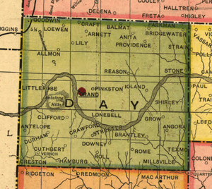
Day County was one of the first counties in Oklahoma Territory. It was located in the western part of the territory, right next to the Texas border. When it was first created in 1890, it was called E County. Many Oklahoma counties at that time were just known by letters. Later, it was named after Charles Day. He was the person who built the first courthouse in the county's main town, Ioland, Oklahoma, which no longer exists today.
Contents
History of Day County
Before Oklahoma Territory was formed, the land that became Day County was part of the Cheyenne-Arapaho reservation. This area was bordered by the Cherokee Outlet and Roger Mills County.
Ranchers and Farmers: A Land Dispute
A big issue in Day County was how land should be used. Should it be "free-range" (meaning unfenced) or should cattle movement be controlled? Large cattle ranches had started when the land was still under Texas law. But when the U.S. created Oklahoma Territory, Texas laws no longer applied.
Many new settlers during the territorial days were small farmers. At first, the cattle ranchers had more political power. If a farmer's crops were eaten by free-range cattle, the farmer often had no way to get paid for their loss. This led to many arguments and disagreements between ranchers and farmers.
How Day County Ended
When Oklahoma officially became a state on November 16, 1907, Day County was dissolved. The county lines were redrawn across the territory. Day County was split into different parts.
The area north of the Canadian River became part of Ellis County. The land south of the river is now the northern part of Roger Mills County. Also, a small strip of land in the northeast of the old county became part of Woodward County.
Grand was a town that used to be the county seat for Roger Mills County. But in 1908, an election moved the county seat to the town of Arnett. Most people moved away from Grand by 1914, and today, there are no visible remains of the town.
Geography of Day County
Day County included the Antelope Hills. These hills are a well-known historical landmark in the area.
Neighboring Areas
- North – Ellis County, Oklahoma Territory
- East – County D, Oklahoma Territory (later named Dewey County)
- Southeast – County G, Oklahoma Territory (later named Custer County)
- South – Roger Mills County, Oklahoma Territory
- West – Texas panhandle
Towns Once in Day County
Some towns that are still around today were once part of Day County:


