
Deep Creek Valley facts for kids
Quick facts for kids Deep Creek Valley |
|
|---|---|

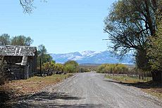
View southeasterly across valley, west flank
Deep Creek Mountains |
|

Deep Creek Valley
Location in Utah
|
|
| Length | 35 mi (56 km) N-S |
| Width | 4 mi (6.4 km) |
| Geography | |
| Country | United States |
| State | Utah |
| Regions | Great Basin and Great Salt Lake Desert |
| Counties | Tooele and Juab |
| Communities | Ibapah and Gold Hill |
| Borders on |
List
|
| Rivers | Deep Creek and East Deep Creek |
Deep Creek Valley is a long valley found in the southwestern part of Utah. It stretches for about 35 miles (56 km) and sits right on the border between Utah and Nevada. Most of the valley is in Tooele County, but a small part in the very south reaches into Juab County.
This valley runs alongside the Deep Creek Mountains, which are to its east. Both the valley and the mountains generally go from north to south. Towards its northern end, the valley opens up into the southwestern part of the Great Salt Lake Desert. In the south, the mountains curve around, creating a higher area within the valley. This is where you'll find part of the Confederated Tribes of the Goshute Reservation. The community of Goshute is also nearby.
Exploring Deep Creek Valley
Deep Creek Valley is shaped by the Deep Creek, which flows north through it. This creek is very important to the valley's landscape.
Waterways and the Landscape
In the southern half of the valley, many smaller creeks and washes flow into Deep Creek. These come from the Deep Creek Mountains. For example, near Ibapah, which is on Deep Creek, and further south towards Goshute, nine different canyons and washes feed into the main creek system.
On the western side of the valley, hills are about 7 to 9 miles (11 to 14 km) away. Washes from these hills flow east or northeast, also joining the valley's water system.
Valley Shape and Surroundings
Deep Creek Valley is quite narrow, only about 4 miles (6.4 km) wide in most places. It winds around small hills, like Gold Hill to the northeast and the Ferber Hills to the northwest, which are right on the Utah-Nevada border.
A place called White Sage Flat is located where Deep Creek meets the northwest part of the Deep Creek Range. Many washes and creeks come together here. However, Deep Creek continues its journey flowing north. The center of the valley is between White Sage Flat and Ibapah to the south.
-
View in Ibapah, UT

