Deerlick Run facts for kids
Quick facts for kids Deerlick Run |
|
|---|---|

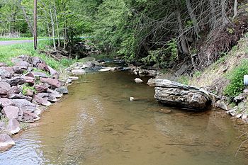
Deerlick Run from Whites Church Road looking downstream
|
|
| Physical characteristics | |
| Main source | Mount Pleasant Township, Columbia County, Pennsylvania |
| River mouth | Orange Township at Fishing Creek less than 600 feet (180 m) above sea level |
| Length | 3.8 mi (6.1 km) |
| Basin features | |
| Progression | Deerlick Run → Fishing Creek → Susquehanna River → Chesapeake Bay |
| Basin size | 6.1 sq mi (16 km2) |
Deerlick Run (also known as Deer Lick Run) is a small stream, or tributary, located in Columbia County, Pennsylvania, in the United States. It flows into Fishing Creek. The stream is about 3.8 miles (6.1 km) long. It flows through two areas: Mount Pleasant Township and Orange Township. The land around the stream, called its watershed, covers about 6.1 square miles. Most of this land is used for farming.
Contents
Where Deerlick Run Flows
Deerlick Run begins in the northern part of Mount Pleasant Township. This is close to a small community called Welliversville.
The stream flows mostly southeast for several miles. It travels through a valley that isn't very deep. Then, it reaches the eastern part of Mount Pleasant Township. Here, the stream changes direction and starts flowing eastward.
After leaving Mount Pleasant Township, Deerlick Run enters Orange Township. It then leaves its valley and flows onto a flatter area called a plain. Soon after, it meets and joins Fishing Creek. This meeting point is just north of Pennsylvania Route 487.
Deerlick Run does not have any smaller streams or "tributaries" that are officially named.
Water and Weather Around the Stream
Deerlick Run carries a lot of sediment, which is like fine dirt or sand. This sediment can build up in the stream, a process called siltation. The stream banks also experience erosion, meaning the soil along the sides washes away.
The amount of sediment carried by the stream is quite high. This can affect the water quality and the creatures living in the stream.
The area around Deerlick Run gets about 37.7 inches (96 cm) of rain each year. About 1.8 inches (4.6 cm) of this rain flows into the stream as runoff.
There aren't many trees or plants along the edges of Deerlick Run. These plants, called a riparian buffer, usually help protect the stream banks and keep the water clean. Because of this, the water in Deerlick Run does not meet the clean water standards set by the Pennsylvania Department of Environmental Protection.
Land and Rocks
The land around Deerlick Run varies in height. The lowest points are less than 600 feet (180 m) above sea level. The highest points are more than 1,100 feet (340 m) above sea level. The stream is located in a geographical area known as the Ridge-and-Valley Appalachians. This area has long, parallel ridges and valleys.
Most of the rocks on the surface in the Deerlick Run area are sedimentary rock. These rocks are made up of layers of different materials, like sand and clay. About 20 percent of the surface rock is sandstone. The soil types in the watershed are mostly clayey or silty soils (90%) and some loamy or sandy soils (10%).
The Stream's Watershed
The watershed of Deerlick Run is the entire area of land where all the rain and snowmelt drain into the stream. This watershed covers about 6.1 square miles. Inside this area, there are about 8.5 miles (13.7 km) of streams in total.
Most of the land in the watershed (about 60.8 percent) is used for farming. This includes areas for hay, pastures, and crops. A good portion (about 34.9 percent) of the land is covered by forests. A small part (4.0 percent) has some buildings or development. There are also some wetland areas, which are like marshy lands, making up 0.3 percent of the watershed.
History of Deerlick Run
Back in 1853, Deerlick Run actually formed part of the border between Columbia County and Montour County. Today, it's located closer to the center of Columbia County.
In the past, the valley where Deerlick Run flows was a busy place with different industries. While we don't know all the details, there are signs of old buildings. You can still see the remains of a dam on the stream. There were also mills that used the stream's water power, including a gin mill (for processing cotton), a sawmill (for cutting wood), and a woolen mill (for making wool products). A mill known as the Behm Mill was built on the stream way back in 1801. An ice house, used to store ice, was also once built near the stream.
Animals and Plants
Deerlick Run is considered a "coldwater fishery." This means its water is cold enough to support certain types of fish, especially those from the Salmonidae family, like trout. It's also called a "migratory fishery." This is because it's part of the larger Susquehanna River watershed, which is a path for fish that migrate, or travel, to different areas.
 | Sharif Bey |
 | Hale Woodruff |
 | Richmond Barthé |
 | Purvis Young |

