
Denver, Pennsylvania facts for kids
Quick facts for kids
Denver, Pennsylvania
|
|
|---|---|
|
Borough
|
|
,_Nov._2013.jpg)
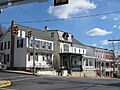
Downtown Denver at the intersection of Main and 4th streets
|
|

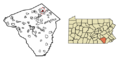
Location of Denver in Lancaster County, Pennsylvania
|
|

Denver, Pennsylvania
Location in Pennsylvania

Denver, Pennsylvania
Location in the United States
|
|
| Country | United States |
| State | Pennsylvania |
| County | Lancaster |
| Area | |
| • Total | 1.30 sq mi (3.36 km2) |
| • Land | 1.28 sq mi (3.31 km2) |
| • Water | 0.02 sq mi (0.05 km2) |
| Elevation | 394 ft (120 m) |
| Population
(2020)
|
|
| • Total | 3,792 |
| • Density | 2,964.82/sq mi (1,144.48/km2) |
| Time zone | UTC-5 (EST) |
| • Summer (DST) | UTC-4 (EDT) |
| ZIP Code |
17517
|
| Area codes | 717 and 223 |
| FIPS code | 42-18888 |
Denver is a small town, called a borough, located in Lancaster County, Pennsylvania, in the United States. In 2020, about 3,794 people lived there.
Contents
History of Denver

How Denver Started
Denver was founded in 1735 by Hans Bucher, who was an immigrant from Switzerland. It was first known as Bucher's Thal, which means "Bucher Valley". This name came from the nearby Cocalico Creek.
In the mid-1700s, a gristmill (a mill for grinding grain) was built along the creek. By 1772, there were six houses in the area. A blacksmith shop and a sawmill were also working by 1820. The area had good soil and limestone deposits. Limestone was used to make building materials like mortar and plaster. Later, people realized it could also be used as fertilizer for farms. By the 1850s, several limestone quarries were open.
Changing the Town's Name
During the Civil War, a train line called the Reading and Columbia Railroad was built through the town. Because of this, the town's name was changed to "Union Station". However, people living there soon got tired of their town being called a train station.
So, in 1881, a man named Adam Brubaker looked for a unique name. He found only one other place named Denver in the country. On November 1, 1881, the town was officially renamed Denver.
Becoming a Borough
By the late 1800s, Denver was growing. Some residents thought about making it an official borough. A big fire at a local tavern, the Denver House, in 1868 helped them decide. There wasn't enough water to fight the fire.
This made some important citizens, like Aaron Shirk, W.D. Fink, and Ephraim Renninger, push for the town to become a borough. They wanted to create a proper water system. They applied in April 1900, and by December, Denver officially became a borough. It was much smaller then, about a quarter of its current size.
New Industries and Achievements
After becoming a borough, Denver bought land for a reservoir and built a water plant. This plant started working in 1902. A quarry that is still open today was started in 1906 by Abram G. Kurtz.
Around the time Denver became a borough, making cigars was a big industry. But machines soon took over, and hand-rolling cigars became less common. New businesses started, like the F&M Hat Company. It was founded in 1912 by brothers Samuel and Daniel Fichthorn and their brother-in-law Ambrose Marburger. F&M Hat quickly became the biggest employer in town. It gave many people jobs in its factory. By 1939, it had 835 employees working two shifts.
In 1977, the Cocalico Eagles boys basketball team won the state championship. They beat Mercer 75–59 in the PIAA Class AA state game.
The Bucher's Mill Covered Bridge, located south of Denver, was added to the National Register of Historic Places in 1980.
Geography of Denver
Denver is located in the northeastern part of Lancaster County. Its exact location is 40°14′2″N 76°8′14″W / 40.23389°N 76.13722°W. To the southeast, it borders Reamstown, and to the southwest, it borders Stevens.
Interstate 76, also known as the Pennsylvania Turnpike, runs along the northern side of Denver. The closest exit is about 3 miles (5 km) to the east. Denver is about 17 miles (27 km) northeast of Lancaster and 15 miles (24 km) southwest of Reading.
The town covers about 1.3 square miles (3.4 km²). A very small part of this area, about 0.02 square miles (0.05 km²), is water. Denver sits in a valley. The Cocalico Creek is to the west, and Little Cocalico Creek is to the east. These two creeks meet at the southern edge of the town. Cocalico Creek flows into the Conestoga River, which is part of the larger Susquehanna watershed.
People in Denver (Demographics)
| Historical population | |||
|---|---|---|---|
| Census | Pop. | %± | |
| 1910 | 933 | — | |
| 1920 | 1,125 | 20.6% | |
| 1930 | 1,203 | 6.9% | |
| 1940 | 1,428 | 18.7% | |
| 1950 | 1,658 | 16.1% | |
| 1960 | 1,875 | 13.1% | |
| 1970 | 2,248 | 19.9% | |
| 1980 | 2,018 | −10.2% | |
| 1990 | 2,861 | 41.8% | |
| 2000 | 3,332 | 16.5% | |
| 2010 | 3,861 | 15.9% | |
| 2020 | 3,794 | −1.7% | |
| 2021 (est.) | 3,770 | −2.4% | |
| Sources: | |||
Based on the 2010 census, about 15,391 people lived in the 17517 zip code area. There were 5,507 households, and 4,204 of these were families.
Most people in the borough were White (96.5%). A smaller number were Black or African American (1.2%), or Asian (2.2%). Some people were from other races or from two or more races. About 2.28% of the population identified as Hispanic or Latino.
In terms of households, about 36.5% had children under 18 living with them. Most households (61.4%) were married couples living together. About 21.1% of all households were made up of people living alone.
The average age of people in the borough was 38.7 years. About 26.5% of the population was under 18 years old.
Education in Denver
Denver is part of the Cocalico School District.
Images for kids
-
Downtown Denver at the intersection of Main and 4th streets
-
Location of Denver in Lancaster County, Pennsylvania
See also
 In Spanish: Denver (Pensilvania) para niños
