Department of Ucayali facts for kids
Quick facts for kids
Department of Ucayali
Gobierno Regional de Ucayali
|
|||
|---|---|---|---|
| Regional Government of Ucayali | |||
|
|||

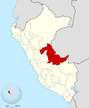
Location of the Ucayali department in Peru
|
|||
| Country | Peru | ||
| Subdivisions | 4 provinces and 14 districts | ||
| Largest city | Pucallpa | ||
| Capital | Pucallpa | ||
| Area | |||
| • Total | 101,830.64 km2 (39,317.03 sq mi) | ||
| Elevation
(Capital)
|
120 m (390 ft) | ||
| Highest elevation | 350 m (1,150 ft) | ||
| Lowest elevation | 135 m (443 ft) | ||
| Population
(2017)
|
|||
| • Total | 496,459 | ||
| • Density | 4.875340/km2 (12.627073/sq mi) | ||
| UBIGEO |
25
|
||
| Dialing code | 061 | ||
| ISO 3166 code | PE-UCA | ||
| Principal resources | Wood, fruit. | ||
| Poverty rate | 33.5% | ||
| Percentage of Peru's GDP | 0.85% | ||
| Website | www.regionucayali.gob.pe | ||
Ucayali (pronounced oo-kah-YAH-lee) is a large area in Peru. It's called a "department," which is like a state or region. This department is located deep in the Amazon rainforest. Its name comes from the Ucayali River, a big river that flows through it.

The main city and capital of Ucayali is Pucallpa. Ucayali is the second largest department in Peru. It's even a bit bigger than the country of South Korea!
Contents
Geography
Where is Ucayali?
The Ucayali department is in the eastern part of Peru. It shares borders with several other places. To the east, it touches the Brazilian state of Acre. To the southeast, it borders the department of Madre de Dios.
To the south, you'll find the Cusco department. On the west, it borders Junín, Pasco, and Huánuco. Finally, to the north, it borders the Loreto department.
People of Ucayali
How Many People Live Here?
In 2017, about 496,459 people lived in the Ucayali department. A little more than half of them were boys and men (51.4%). Most people (75.3%) live in cities and towns. The rest (24.7%) live in the countryside.
What Languages Do They Speak?
Most people in Ucayali speak Spanish as their first language (87.6%). But many other languages are also spoken! About 4.1% of people speak Asháninka. Another 1.5% speak Quechua, and 0.1% speak Aymara. Other native languages, like Shipibo, are spoken by 6.6% of the population.
Where Do People Come From?
Many people living in Ucayali have moved there from other parts of Peru. About 34.7% of the population came from different departments. A small number (0.2%) were born in other countries. The largest group of people who moved to Ucayali came from the Loreto Region.
Age Groups
The population of Ucayali is quite young. More than half of the people (53.9%) are under 20 years old. About 9.3% are between 20 and 24. Another 25.4% are between 25 and 44. Only a small part of the population (2.5%) is 65 years old or older.
Learning and Schools
When it comes to education, 29% of people have finished high school. About 2.3% have gone to other higher education schools that are not universities. And 1.7% have completed university studies. Many people (49.3%) have only attended elementary school. Sadly, 9.1% of the population has not had any formal education. The number of people who cannot read or write in the region is 14.2%.
How Ucayali is Organized
The Ucayali department is divided into smaller areas. These are called 4 "provinces." Each province is then divided into even smaller areas called "districts." There are 14 districts in total.
Provinces of Ucayali
Here are the provinces and their main cities (capitals):
- Atalaya (capital: Atalaya)
- Coronel Portillo (capital: Pucallpa)
- Padre Abad (capital: Aguaytía)
- Purús (capital: Esperanza)
Fun Places to Visit
Ucayali has some amazing natural areas and interesting places to see:
- El Sira Communal Reserve
- Gran Pajonal
- Purús Communal Reserve
- Immaculate Conception Cathedral, Pucallpa
See also
 In Spanish: Departamento de Ucayali para niños
 | Dorothy Vaughan |
 | Charles Henry Turner |
 | Hildrus Poindexter |
 | Henry Cecil McBay |


