Des Arc, Arkansas facts for kids
Quick facts for kids
Des Arc, Arkansas
|
|
|---|---|
|
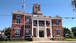
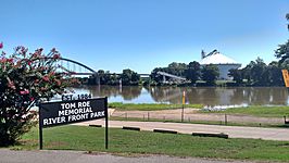
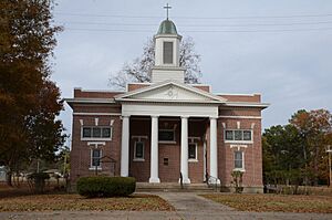
Clockwise from top: Prairie County Courthouse, Northern District, Downtown Des Arc, the White River, city park and bridge, and the Lower White River State Park
|
|

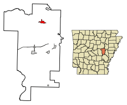
Location of Des Arc in Prairie County, Arkansas.
|
|
| Country | |
| State | |
| County | Prairie |
| Incorporated | 1854 |
| Named for | "At the bend" in French |
| Government | |
| • Type | Mayor–Council |
| Area | |
| • Total | 2.11 sq mi (5.46 km2) |
| • Land | 2.10 sq mi (5.45 km2) |
| • Water | 0.01 sq mi (0.02 km2) |
| Elevation | 207 ft (63 m) |
| Population
(2020)
|
|
| • Total | 1,905 |
| • Density | 906.28/sq mi (349.83/km2) |
| Time zone | UTC−06:00 (Central (CST)) |
| • Summer (DST) | UTC−05:00 (CDT) |
| ZIP Code |
72040
|
| Area code(s) | 870 |
| FIPS code | 05-18550 |
| GNIS feature ID | 2404222 |
Des Arc (pronounced DEZ-ark) is a city in Arkansas, located right on the White River. It's the biggest city in Prairie County and serves as the main town for the county's northern area.
The city was officially started in 1854. Being on the river was very important for Des Arc's early days. It was a busy port for shipping lumber. However, being on the river also meant the city faced big floods in 1927 and 1937. As river shipping became less common, other ways of travel like railroads and highways didn't pass through Des Arc as much.
Even so, Des Arc's history is well-kept. Seven of its buildings are listed on the National Register of Historic Places. You can learn more about the area's past at the Lower White River Museum State Park. The city's population has been around 1,700 to 2,000 people for a while. In 2020, about 1,905 people lived there.
Contents
History of Des Arc
People from Europe first settled in this area, the Lower White River Valley, when it was part of French Louisiana. This was a long time ago, between 1686 and 1763. French explorers and traders from Canada and southern Louisiana often traveled through here. They hunted animals like bears and trapped for furs.
These furs and bear oil were then sent down the river to Arkansas Post. This was the only main settlement in the region back then. From there, the goods likely went to New Orleans. During this time, the French gave names to many places, including Des Arc. The name "Des Arc" means "at the bend" in French, probably because of a bend in the river. Other places in Prairie County, like La Grue, also got French names.
Des Arc was officially founded in 1854. Early maps show that the town was planned with 80 blocks for homes. It also had two blocks set aside for shops and businesses. Most of the streets and blocks in Des Arc today still follow that original 1854 plan. The streets running east-west started with McNulty Street in the north. This is close to where Highway 38 is now. The street furthest south was Barrier Street. The town stretched from Foster Street (now called First Street) in the east to what is now Eighth Street.
Geography and Location

Des Arc is located in a part of Arkansas called the Arkansas Delta. This area is part of a much larger flat region known as the Mississippi Alluvial Plain. This plain was formed by rich, fertile soil left behind by the Mississippi River over many years. It stretches from Louisiana all the way to Illinois.
The White River Lowlands, where Des Arc is, have many swamps and forests. This is different from the southern parts of Prairie County. Those areas are part of the Grand Prairie, which is famous for growing rice and raising fish (aquaculture).
The city of Des Arc covers about 2.0 square miles (5.2 square kilometers). Most of this area is land, with a very small amount of water. Des Arc is about 60 miles (97 km) east of Little Rock. It's also about 95 miles (153 km) west of Memphis, Tennessee. Within Prairie County, Des Arc is the city furthest north. It's about 10 to 15 miles (16 to 24 km) north of other towns like Hazen and DeValls Bluff.
Climate in Des Arc
Prairie County has a humid subtropical climate. This means it has all four seasons. Summers can be very hot and humid. Winters are usually mild, with not much snow.
July is the hottest month. The average high temperature is about 92°F (33°C). The average low is around 73°F (23°C). Sometimes, temperatures can even go above 100°F (38°C). January is the coldest month. The average high is about 48°F (9°C), and the average low is around 31°F (-1°C). The highest temperature ever recorded was 109°F (43°C). The lowest was -5°F (-21°C). The most snow Des Arc ever got was 18 inches (46 cm) on January 7, 1912.
| Climate data for Des Arc, Arkansas (1991–2020 normals, extremes 1903–1908, 1940–present) | |||||||||||||
|---|---|---|---|---|---|---|---|---|---|---|---|---|---|
| Month | Jan | Feb | Mar | Apr | May | Jun | Jul | Aug | Sep | Oct | Nov | Dec | Year |
| Record high °F (°C) | 80 (27) |
82 (28) |
93 (34) |
93 (34) |
98 (37) |
105 (41) |
109 (43) |
109 (43) |
105 (41) |
98 (37) |
87 (31) |
83 (28) |
109 (43) |
| Mean maximum °F (°C) | 70.4 (21.3) |
73.9 (23.3) |
81.6 (27.6) |
85.6 (29.8) |
90.3 (32.4) |
95.0 (35.0) |
99.6 (37.6) |
100.4 (38.0) |
95.4 (35.2) |
88.2 (31.2) |
78.2 (25.7) |
71.1 (21.7) |
100.8 (38.2) |
| Mean daily maximum °F (°C) | 48.9 (9.4) |
53.9 (12.2) |
62.9 (17.2) |
72.6 (22.6) |
81.0 (27.2) |
88.9 (31.6) |
92.0 (33.3) |
91.4 (33.0) |
84.9 (29.4) |
74.7 (23.7) |
61.7 (16.5) |
51.8 (11.0) |
72.1 (22.3) |
| Daily mean °F (°C) | 40.8 (4.9) |
45.0 (7.2) |
53.7 (12.1) |
62.9 (17.2) |
71.7 (22.1) |
79.7 (26.5) |
82.7 (28.2) |
81.6 (27.6) |
74.8 (23.8) |
63.6 (17.6) |
52.2 (11.2) |
43.7 (6.5) |
62.7 (17.1) |
| Mean daily minimum °F (°C) | 32.6 (0.3) |
36.1 (2.3) |
44.4 (6.9) |
53.2 (11.8) |
62.4 (16.9) |
70.6 (21.4) |
73.4 (23.0) |
71.9 (22.2) |
64.6 (18.1) |
52.6 (11.4) |
42.7 (5.9) |
35.6 (2.0) |
53.3 (11.8) |
| Mean minimum °F (°C) | 13.9 (−10.1) |
18.0 (−7.8) |
23.3 (−4.8) |
32.2 (0.1) |
43.0 (6.1) |
56.6 (13.7) |
61.8 (16.6) |
59.4 (15.2) |
46.4 (8.0) |
33.0 (0.6) |
23.3 (−4.8) |
17.3 (−8.2) |
13.5 (−10.3) |
| Record low °F (°C) | −8 (−22) |
−4 (−20) |
10 (−12) |
28 (−2) |
37 (3) |
46 (8) |
53 (12) |
48 (9) |
32 (0) |
23 (−5) |
13 (−11) |
−2 (−19) |
−8 (−22) |
| Average precipitation inches (mm) | 3.68 (93) |
4.04 (103) |
5.16 (131) |
5.53 (140) |
5.40 (137) |
3.01 (76) |
3.10 (79) |
2.89 (73) |
3.32 (84) |
4.23 (107) |
4.43 (113) |
5.25 (133) |
50.04 (1,271) |
| Average snowfall inches (cm) | 0.6 (1.5) |
0.8 (2.0) |
0.7 (1.8) |
0.0 (0.0) |
0.0 (0.0) |
0.0 (0.0) |
0.0 (0.0) |
0.0 (0.0) |
0.0 (0.0) |
0.0 (0.0) |
0.1 (0.25) |
0.1 (0.25) |
2.3 (5.8) |
| Average precipitation days (≥ 0.01 in) | 8.7 | 8.7 | 9.8 | 9.4 | 9.9 | 7.0 | 6.8 | 6.3 | 5.9 | 7.1 | 8.2 | 9.2 | 97.0 |
| Average snowy days (≥ 0.1 in) | 0.4 | 0.6 | 0.2 | 0.0 | 0.0 | 0.0 | 0.0 | 0.0 | 0.0 | 0.0 | 0.1 | 0.1 | 1.4 |
| Source: NOAA | |||||||||||||
Population Information
| Historical population | |||
|---|---|---|---|
| Census | Pop. | %± | |
| 1880 | 548 | — | |
| 1890 | 546 | −0.4% | |
| 1900 | 640 | 17.2% | |
| 1910 | 1,061 | 65.8% | |
| 1920 | 1,307 | 23.2% | |
| 1930 | 1,348 | 3.1% | |
| 1940 | 1,410 | 4.6% | |
| 1950 | 1,612 | 14.3% | |
| 1960 | 1,482 | −8.1% | |
| 1970 | 1,714 | 15.7% | |
| 1980 | 2,001 | 16.7% | |
| 1990 | 2,001 | 0.0% | |
| 2000 | 1,933 | −3.4% | |
| 2010 | 1,717 | −11.2% | |
| 2020 | 1,905 | 10.9% | |
| U.S. Decennial Census 2014 Estimate |
|||
2020 Census Details
In 2020, the 2020 United States census counted 1,905 people living in Des Arc. There were 715 households and 446 families. Most of the people living in Des Arc were White (81.21%). The next largest group was Black or African American (13.7%). There were also smaller numbers of Native American, Asian, and people of mixed races. About 1.31% of the population was Hispanic or Latino.
| Race | Number | Percentage |
|---|---|---|
| White (non-Hispanic) | 1,547 | 81.21% |
| Black or African American (non-Hispanic) | 261 | 13.7% |
| Native American | 3 | 0.16% |
| Asian | 3 | 0.16% |
| Other/Mixed | 66 | 3.46% |
| Hispanic or Latino | 25 | 1.31% |
Culture and Daily Life
Des Arc has several important historical buildings. Seven of these are listed on the National Register of Historic Places. This means they are recognized for their historical importance. One example is the Bethel House, located at Erwin and 2nd Streets. It was designed by a famous architect named Charles L. Thompson.
Education in Des Arc
Students in Des Arc attend schools that are part of the Des Arc School District.
- Des Arc Pre-K
- Des Arc Elementary School (for grades K-6)
- Des Arc High School (for grades 7-12)
See also
 In Spanish: Des Arc (Arkansas) para niños
 | Dorothy Vaughan |
 | Charles Henry Turner |
 | Hildrus Poindexter |
 | Henry Cecil McBay |


