
Desert Uplands facts for kids
The Desert Uplands is a special natural area, or bioregion, in Queensland, Australia. It stretches across the middle of Queensland, from the north to the central west, crossing the Great Dividing Range. Think of it as a unique part of the land with its own plants, animals, and climate.
This area is home to important lakes like Lake Galilee, Lake Dunn, and Lake Buchanan. The weather here is often dry, with rainfall that changes a lot from year to year. A big part of the Desert Uplands is used for raising cattle. It also sits over a huge underground water supply called the Great Artesian Basin.
Contents
Exploring the Desert Uplands
The Desert Uplands is a large area in Queensland, known for its unique environment. It's a place where the land, plants, and animals work together to create a distinct ecosystem.
Where is the Desert Uplands Located?
This bioregion is found in both northern and central western parts of Queensland. It crosses the famous Great Dividing Range, which is a long chain of mountains and hills. The region stretches between the towns of Blackall and Pentland. To its east are the Brigalow Belt North and Brigalow Belt South regions, and to the north is the Einasleigh Uplands.
What is the Land Like in the Desert Uplands?
The climate in the Desert Uplands is semi-arid, meaning it's quite dry, like a desert, but not as extreme. The amount of rain it gets can be very different each year. A lot of the land is used for cattle grazing, which means farmers raise cows there. The area is also important because it's part of the Great Artesian Basin, which is one of the largest underground freshwater reserves in the world. This basin helps supply water to many parts of inland Australia.
Towns and Communities
The two main towns in the Desert Uplands bioregion are Barcaldine and Aramac. These towns serve as important centers for the people who live and work in this large rural area.
Plants and Trees of the Region
A common type of grass found here is Spinifex grass. This tough grass is well-suited to the dry conditions. Unfortunately, over 80 different types of weeds have also been found in the Desert Uplands. Weeds are plants that grow where they are not wanted and can harm native plants.
In 2003, it was estimated that about 13 million trees were being cleared each year in the Desert Uplands. This meant that about 6.8% of the land had been cleared, which was one of the highest rates for any bioregion in Queensland at that time.
Rivers and Wetlands
The main rivers that flow through the Desert Uplands include the Belyando, Cape, Campaspe, Barcoo, and Alice River. There are also smaller waterways like Aramac and Torrens Creeks.
The region also has important wetlands, which are areas of land covered by water. These include shallow salt lakes like Lake Galilee and Lake Buchanan. These wetlands are so important that they are listed on the Directory of Important Wetlands in Australia, which means they are recognized for their special environmental value.
Images for kids
-
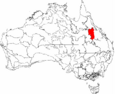
The IBRA regions of Australia, with Desert Uplands in red

