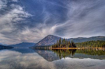
Dirtyface Peak facts for kids
Quick facts for kids Dirtyface Peak |
|
|---|---|

Dirtyface Mountain, SE aspect, from Lake Wenatchee
|
|
| Highest point | |
| Elevation | 6,240+ ft (1,900+ m) |
| Prominence | 3,320 ft (1,010 m) |
| Isolation | 4.54 mi (7.31 km) |
| Parent peak | Mount Sylvester (6,913 ft) |
| Geography | |
| Location | Glacier Peak Wilderness Chelan County, Washington, U.S. |
| Parent range | North Cascades Cascade Range |
| Topo map | USGS Lake Wenatchee |
| Climbing | |
| Easiest route | scrambling |
Dirtyface Peak is a tall mountain in Washington state, located near Lake Wenatchee. It stands about 6,243 feet (1,903 meters) high. This makes it one of the higher peaks in Washington. Dirtyface Peak is the highest point of Dirtyface Mountain. It is part of the Okanogan-Wenatchee National Forest, which means it's protected land. Climbing it is a long and challenging hike, about 9.5 miles (15.3 km) round trip. Hikers gain about 4,300 feet (1,311 meters) in elevation during the climb.
How Mountains Formed
The North Cascades are a mountain range with very rugged land. They have sharp peaks, long ridges, and deep valleys carved by glaciers. The way these mountains look today is because of big geological events that happened millions of years ago. These events caused huge changes in elevation and created different climates across the Cascade Range.
The Cascade Mountains started forming a very long time ago. This was during the late Eocene Epoch, which was millions of years ago. At that time, the North American Plate (a huge piece of Earth's crust) was slowly moving over the Pacific Plate. This movement caused many volcanic eruptions.
Earth's Moving Plates
Small pieces of Earth's crust, called terranes, also played a role. These pieces of land slowly joined together to form the North Cascades about 50 million years ago. Imagine giant puzzle pieces of land slowly coming together.
Ice Age and Glaciers
Later, during the Pleistocene period, which began over two million years ago, glaciers were very active. These huge sheets of ice moved across the land, carving and shaping the mountains and valleys. Glaciation was strongest about 18,000 years ago. Most valleys were free of ice by 12,000 years ago.
The combination of land being pushed upwards (called uplift) and cracks in the Earth's crust (called faulting) along with the action of glaciers created the tall peaks and deep valleys we see in the North Cascades today.
 | Jackie Robinson |
 | Jack Johnson |
 | Althea Gibson |
 | Arthur Ashe |
 | Muhammad Ali |


