
Distillery District facts for kids
Quick facts for kids
Distillery District
|
|
|---|---|
|
Neighbourhood
|
|

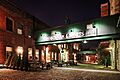
Distillery District street level
|
|
 |
|
| Country | Canada |
| Province | Ontario |
| City | Toronto |
| Time zone | UTC−5 (Eastern) |
| • Summer (DST) | UTC−4 (EDT) |
| Official name: Gooderham and Worts Distillery National Historic Site of Canada | |
| Designated: | 11 November 1988 |
The Distillery District is a cool area in Toronto, Ontario, Canada. It's east of downtown. This neighbourhood has many cafés, restaurants, and shops. They are all inside old buildings that used to be part of the Gooderham and Worts Distillery.
This area is about 13 acres (5.3 hectares) big. It has over forty old buildings and ten streets. It's the biggest collection of old factory buildings from the Victorian era in North America. In 1988, it was named a National Historic Site of Canada. This means it's a very important place in Canadian history.
Contents
History of the Distillery District
The Gooderham and Worts Distillery started way back in 1832. It made a lot of whisky, mostly to sell to other countries. Later, another big Canadian company, Hiram Walker, bought it. The distillery was located near the Canadian National Railway and the Don River. This made it easy to transport goods all over Canada and the world. Toronto became a major industrial city because of places like this.

In the late 1900s, many factories in the area closed down. The distillery also stopped most of its operations. This left the district looking old and empty. But when the distillery fully closed in 1990, it opened up new chances. The district had the largest and best-kept collection of Victorian-era factory buildings in North America.
Because of its history, the Distillery District was named a National Historic Site. It has also been protected by the Ontario Heritage Act since 1976. National Geographic magazine even called it a "top pick" for travelers in Canada.
In the 1990s, the economy was not doing well. This slowed down plans to fix up the district. But two apartment buildings were still built nearby. While waiting for new plans, the district became popular for filming movies and TV shows. Since 1990, over 800 films and TV shows have used the area as a set.
The 21st Century Transformation

In 2001, a company called Cityscape Holdings Inc. bought the site. They turned the district into a place just for people walking. The work finished, and the district opened to the public in 2003. The new owners decided not to rent space to big chain stores. Instead, most buildings now have unique shops, art galleries, restaurants, and coffee shops. There's even a famous small brewery called the Mill Street Brewery.
Artists use the upper floors of some buildings as studios. Other offices with a "creative focus" are also there. A new theatre, the Young Centre for the Performing Arts, opened in the district. It is home to the Soulpepper Theatre Company and the George Brown Theatre School. There are also plans to build more apartments, offices, and shops in the empty areas around the district.
New apartment buildings are being built in the southeast part of the neighbourhood. They are near Cherry Street and Tank House Lane. In 2015, the Athletes' Village for the Pan American Games was built here. After the games, it became homes and shops.
Toronto Christmas Market
The Toronto Christmas Market is a yearly outdoor event held in the Distillery District. It has been a tradition since 2010. The market includes "Santa's house," a pop-up shop, and pet photos with Santa. There is also a Ferris wheel and special shows every day. Many food and dining spots are popular with visitors.
The market in 2020 was canceled because of the COVID-19 pandemic in Toronto.
Exploring the Distillery District
_(15695645646).jpg)
The Distillery District has old brick-paved streets and lanes. Only people walking or riding bikes are allowed on them. Cars can only go on the streets and parking areas outside the main historic part. You'll see several large sculptures along the lanes, making the streets lively. One important landmark is the tall chimney on top of the Boiler House.
There are also open spaces on the walking streets with chairs and tables for everyone to use. Some coffee shops and restaurants have outdoor seating areas too.
Trinity Street is the widest street in the district. It often acts like a public square for events, like market days. The main paths inside the district are Distillery Lane, Trinity Street, and Tank House Lane. The district is bordered by Parliament Street to the west, Mill Street to the north, and Cherry Street to the east.

You can get to the Distillery District using Toronto Transit Commission buses (route 121 Fort York-Esplanade). Since June 2016, the 514 Cherry streetcar line also stops nearby. It takes you along King Street through downtown.
The areas around the district have a mix of uses. There are homes near Parliament and Mill Street. Restaurants are found along Trinity Street, Tank House Lane, and Brewery Lane. There are also schools at the eastern end of Tank House Lane.
Historic Buildings

The old distillery had many buildings, including a tall windmill and a wharf. The windmill and wharf are gone now. But many of the original distillery buildings are still standing. These historic buildings include:
- Stone Distillery, 1859
- Boiler House, around 1859–1860
- Boiler House/Drying Annex, around 1859–1860
- Yeast Store, around 1859–1860
- Malt House, around 1863
- Paint House, around 1863–1864
- Cooperage Building, around 1863–1864
- Office, around 1863–1864
- Rectifying Building, around 1863–1864
- Carpenter's Shop, around 1863–1864
- Cooper's Yard, around 1863–1864
- Kilns Building, around 1863–1864
- Fermenting cellar, 1869
- Cannery buildings, 1873
- Pure Spirits buildings, 1873
- Pure Spirits tank houses, 1873
- Maintenance Shop, around 1877–1880
- Paint Shop, around 1877–1880
- Stables buildings, 1877–1880
- Denaturing Room, around 1884
- Molasses Tank, around 1884–1889
- Tank House 4, around 1884–1889
- East Boiler House, 1886
- Office and Cooperage, 1886
- Lunch Room, around 1887
- Tank House 9, 1889
- Tank House 10, 1889
- Long Room, around 1884–1891
- Rack House D, around 1884–1891
- Rack House G, around 1884–1891
- Rack House H, around 1884–1891
- Rack House I, around 1884–1891
- Rack House J, around 1884–1891
- Pump House, 1896
- Case Goods House, 1927
- Rack House M, 1927
Images for kids
-
The Distillery District is a historic area used for homes, shops, and fun activities.
.jpg)
