Divide, Oregon facts for kids
Quick facts for kids
Divide, Oregon
|
|
|---|---|

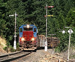
A train passing by Divide
|
|
| Country | United States |
| State | Oregon |
| County | Lane |
| Established | 1900 |
| Elevation | 745 ft (227 m) |
| Time zone | UTC-8 (Pacific (PST)) |
| • Summer (DST) | UTC-7 (PDT) |
| Area code(s) | 458 and 541 |
| GNIS feature ID | 1119961 |
| Elevation and coordinates derived from the Geographic Names Information System | |
Divide is a ghost town located in Lane County, Oregon, in the United States. A ghost town is a place where most people have left, leaving behind empty buildings and a quiet history. Divide is found southwest of Cottage Grove, close to Interstate 5.
Contents
What Was Divide?
Divide was once a small community that grew around a train station. A post office opened there on May 31, 1900. It was first located in Douglas County.
Changes Over Time
The post office later moved or was re-listed in Lane County in 1909. This change might have happened because the county border between Lane and Douglas counties shifted. The post office eventually closed its doors on January 15, 1921.
How Did Divide Get Its Name?
The name "Divide" comes from its special location. It sits near a natural boundary called a watershed divide. This means it's where water flows in different directions.
Water Flowing East and West
On the west side of Divide, water flows into Pass Creek. This creek eventually joins the Umpqua River. On the east side, water flows into the Coast Fork Willamette River, which is part of the Willamette River system. This natural split in water flow gave the town its unique name. The edges of the Siuslaw River watershed are also nearby, just north of Divide.
 | Sharif Bey |
 | Hale Woodruff |
 | Richmond Barthé |
 | Purvis Young |


