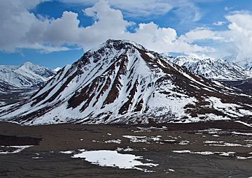
Divide Mountain (Alaska) facts for kids
Quick facts for kids Divide Mountain |
|
|---|---|

Divide Mountain, north aspect
|
|
| Highest point | |
| Elevation | 5,195 ft (1,583 m) |
| Prominence | 938 ft (286 m) |
| Isolation | 2.41 mi (3.88 km) |
| Geography | |
| Location | Denali Borough Alaska, United States |
| Parent range | Alaska Range |
| Topo map | USGS Denali B-1 |
Divide Mountain is a mountain peak in Alaska. It stands 5,195 ft (1,580 m) tall. You can find it inside Denali National Park and Preserve, which is part of the Alaska Range.
This mountain is a famous sight in the Toklat River valley. Visitors can easily see it from the park road. Divide Mountain is about 2 mi (3 km) southwest of Polychrome Pass. It is also 11 mi (18 km) north-northeast of Scott Peak. Even though it's not the tallest mountain, it rises sharply from the valley floor. It climbs over 2,000 ft (610 m) from the land around it. The name "Divide Mountain" was first used on a map in 1916 by the United States Geological Survey.
Understanding Divide Mountain's Weather
Divide Mountain is in a subarctic climate zone. This means it has very long, cold, and snowy winters. The summers are usually mild. Temperatures can drop below −20 °C (that's -4 °F). With the wind chill, it can feel even colder, below −30 °C (-22 °F).
Water Flow and Seasons
Rain and melting snow from the mountain flow into the Toklat River. This river then joins the larger Tanana River system. The best time to visit Divide Mountain is from May through June. The weather during these months is usually the most pleasant for hiking or just enjoying the views.
 | George Robert Carruthers |
 | Patricia Bath |
 | Jan Ernst Matzeliger |
 | Alexander Miles |


