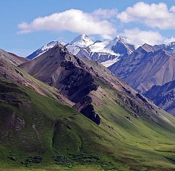
Scott Peak (Alaska) facts for kids
Quick facts for kids Scott Peak |
|
|---|---|

Scott Peak's snowy summit pyramid in back seen from Eielson Visitor Center
|
|
| Highest point | |
| Elevation | 8,828 ft (2,691 m) |
| Prominence | 3,428 ft (1,045 m) |
| Isolation | 9.96 mi (16.03 km) |
| Parent peak | Mount Mather (12,096 ft) |
| Geography | |
| Location | Denali Borough Alaska, United States |
| Parent range | Alaska Range |
| Topo map | USGS Denali B-1 |
| Climbing | |
| First ascent | 1953 |
| Easiest route | Sunset Glacier |
Scott Peak is a tall mountain in Alaska, standing at 8,828 feet (about 2,691 meters) high. It is covered in glaciers, which are like huge, slow-moving rivers of ice. This peak is part of the Alaska Range and is located inside Denali National Park and Preserve.
You can find Scott Peak about 9 miles (14.5 kilometers) southeast of the Eielson Visitor Center. It sits at the very top of the Sunset Glacier. The mountain is also about 33.5 miles (54 kilometers) northeast of Denali, which is North America's highest peak.
This mountain was named in 1953 to honor Gordon D. Scott. He was a surveyor who worked for the U.S. Coast and Geodetic Survey. Sadly, Lieutenant Scott died in a plane crash in 1953 while he was mapping this area. The mountain is about ten miles south of where the crash happened.
Contents
Exploring Scott Peak
People enjoy climbing Scott Peak. Some of the paths climbers use include the Northeast Face, the Northwest Face, and the Sunset Glacier. The very first time someone successfully climbed this peak was in 1953. This historic climb was made by a famous explorer named Bradford Washburn.
Weather and Environment
Scott Peak has a very cold climate. It is in what is called a subarctic climate zone. This means winters are long, very cold, and full of snow. Summers are usually mild.
Temperatures and Glaciers
During winter, temperatures can drop below −20 °C (which is -4 °F). With the wind, it can feel even colder, sometimes below −30 °C (-22 °F). Because it's so cold, glaciers like the Sunrise Glacier and the Sunset Glacier can form and stay on the mountain's slopes.
Water Flow
When snow and ice melt on the north side of Scott Peak, the water flows into smaller streams. These streams eventually join the McKinley River. The McKinley River then flows into the larger Tanana River system. On the south side of the peak, water drains into the Chulitna River.
Best Time to Visit
If you want to see Scott Peak or climb it, the best months to visit are May and June. The weather is usually the most pleasant during this time.
 | Valerie Thomas |
 | Frederick McKinley Jones |
 | George Edward Alcorn Jr. |
 | Thomas Mensah |


