
Dix Mountain Wilderness Area facts for kids
Quick facts for kids Dix Mountain Wilderness Area |
|
|---|---|
|
IUCN Category Ib (Wilderness Area)
|
|

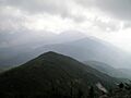
View of Dix Mountain Wilderness from the summit of Giant Mountain.
|
|

Dix Mountain Wilderness Area
Location in the United States
|
|
| Location | Adirondack Park New York USA |
| Nearest city | North River, NY |
| Area | 45,208 acres (183 km2) |
| Governing body | New York State Department of Environmental Conservation |
The Dix Mountain Wilderness Area was once a special protected natural area in New York State. It was part of the larger Adirondack Park. This area was located in Essex County, near towns like Elizabethtown and Keene.
It was bordered by Route 73 to the north and the Adirondack Northway to the east. In 2018, the Dix Mountain Wilderness Area joined with the High Peaks Wilderness Area. This happened after New York State bought more land that connected the two areas.
Contents
Exploring the Mountains and Land
The Dix Mountain area has very rough and rocky land. It is full of mountains. Several mountain tops here are taller than 4,000 feet (about 1,200 meters).
The area also has 12 small ponds. Their total surface area is about 92 acres (37 hectares). You can find tall, steep cliffs, especially in the northern and eastern parts.
Mountain Landslides
Some mountains, like Dix, South Dix, and Macomb, have had small landslides. These usually happen on their steep northern slopes. Landslides leave behind bare rock scars on the upper parts of the mountains.
Tall Peaks Without Trails
There are four mountain peaks in this area that are over 4,000 feet tall. They do not have official hiking trails. These peaks are South Dix, East Dix, Hough, and McComb.
Many hikers reach these mountains from a popular, unofficial trail off Route 73. This trail leads to a scramble up East Dix. From there, hikers follow unofficial paths to connect to the other major peaks.
Forests and Wildfires
In 1903, some of the worst forest fires in the Adirondacks happened here. This was during a long dry period. The fires burned away the trees and even the soil on mountain tops. This left bare rock.
Today, the forest has mostly small yellow birch and aspen trees. At higher elevations, you'll find stunted balsam trees. Lower down, there are mixed hardwood and softwood trees.
Fun Things to Do in the Wilderness
The area has 36.5 miles (58.7 km) of maintained hiking trails. There are also two lean-to shelters for campers. Many popular but unofficial trails exist too. Four of the high peaks in this area can only be reached by these unofficial paths.
Chapel Pond is also in this area. It is a mountain lake surrounded by cliffs. It's a popular spot for rock climbing and ice climbing.
History of the Wilderness Area
The Adirondack Trail Improvement Society helps maintain hiking trails. They work in the northern and northwestern parts of the area. The DEC approves their work.
Their trails go to mountain tops like Round Top Mountain, Noonmark, and Dial. The very steep and rugged land here has helped keep the area wild. This is why it was classified as a wilderness area.
Land Purchases and Mergers
In 1978 and 1980, New York State bought about 9,311 acres (37.7 km²) of land. This land came from the Adirondack Mountain Reserve. About 3,269 acres (13.2 km²) of this land became part of the Dix Mountain Wilderness. This included peaks like Noonmark and Dial.
The state also got a special agreement called a conservation easement. This agreement limits building on the remaining club lands. It also allows the public to walk across the club's land to reach the peaks.
In 2013, New York State bought another 1,450-acre (5.9 km²) piece of land. This was called the Casey Brook Tract. In 2016, the state bought the 20,700-acre (83.8 km²) Boreas Ponds Tract. These purchases created a link of state-owned land. This link connected the Dix Mountain Wilderness Area to the nearby High Peaks Wilderness Area.
Finally, in 2018, the Adirondack Park Agency suggested merging the Dix Mountain Wilderness Area into the High Peaks Wilderness Area. Governor Andrew Cuomo approved this change.
Images for kids
-
View of Dix Mountain Wilderness from the summit of Giant Mountain.
