
Keene, New York facts for kids
Quick facts for kids
Keene, New York
|
|
|---|---|

|
|

Location in Essex County and the state of New York
|
|
| Country | United States |
| State | New York |
| County | Essex |
| Government | |
| • Type | Town Council |
| Area | |
| • Total | 156.62 sq mi (405.64 km2) |
| • Land | 155.94 sq mi (403.89 km2) |
| • Water | 0.68 sq mi (1.75 km2) |
| Elevation | 1,358 ft (414 m) |
| Population
(2020)
|
|
| • Total | 1,144 |
| • Density | 7.34/sq mi (2.83/km2) |
| Time zone | UTC−5 (Eastern (EST)) |
| • Summer (DST) | UTC−4 (EDT) |
| ZIP Code |
12942
|
| Area code(s) | 518 |
| FIPS code | 36-031-39067 |
| GNIS feature ID | 0979113 |
Keene is a small town located in the middle of Essex County, New York. It includes smaller communities called hamlets like Keene, Keene Valley, and St. Huberts. In 2020, about 1,144 people lived here.
The town is a special part of the Adirondack Park. It's home to 15 of the 46 High Peaks, which are New York's tallest mountains. This includes Mount Marcy, the highest mountain in New York State. The beautiful Ausable Lakes, where the Ausable River begins, are also in Keene. Many trails for hiking these tall mountains start in the town.
Contents
History of Keene
The first people settled in what is now Keene Center in 1787. The town of Keene was officially created on March 19, 1808. It was formed from parts of the towns of Jay and Elizabethtown.
Early Challenges and Growth
The area is very mountainous, with rocks close to the surface. This means there isn't much good land for farming. Because of this, Keene has always had a small population. A road was built along the Ausable River around 1797, connecting Keene Center to Jay. However, it was often hard to travel on because of the rough land.
Keene was important for education in the Adirondacks. It set up the very first school district in the region. The first meeting for the school's leaders happened in 1813.
Industries and Communities
At first, the town's economy was based on cutting down trees for lumber and digging for iron. But it was hard to send lumber out of the area, so most of it was used locally. The first sawmill was built in 1823. Soon after, places to make iron and grind grain (gristmills) were also built.
The first community grew up along the river, called Keene Central. By 1840, another community called Keene Flats developed, which was later renamed Keene Valley in 1883.
Modern Connections
In 2011, the town worked together to bring high-speed internet (broadband) to most homes in Keene. They even made sure every home with a student in the public school got internet. This project was special because it brought internet to a rural area within the Adirondack Park.
Several historic places in Keene are listed on the National Register of Historic Places. These include the Hurricane Mountain Fire Observation Station, Slater Bridge, and Walton Bridge.
Geography of Keene
Keene covers about 405.6 square kilometers (156.6 square miles). Most of this area is land, with a small amount of water.
Mountains and Waterways
Many of the famous High Peaks are found in or near Keene. This includes Mount Marcy, which is 5,343 feet (1,629 meters) tall and is the highest point in New York State. A popular starting point for hikers, called The Garden, is in Keene Valley. From here, you can reach Johns Brook Lodge, Mount Marcy, and the heart of the High Peaks.
The Lower Ausable Lake and the northern part of the Upper Ausable Lake are in Keene. The East Branch of the Ausable River flows north from the Lower Ausable Lake. It passes through the hamlets of St. Huberts, Keene Valley, and Keene. Hull's Falls, a beautiful waterfall near Keene, is a popular spot to visit.
Roads in Keene
Two main roads, New York State Route 9N and New York State Route 73, pass through Keene. They help connect the town to other areas.
-
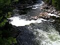
Hull's Falls on the Ausable River
-
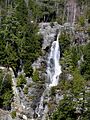
Roaring Brook Falls near St. Huberts


Population and People
As of the census in 2000, there were 1,063 people living in Keene. The town had 443 households. About 29.6% of these households had children under 18 living with them.
The average age of people in Keene was 45 years old. About 21.8% of the population was under 18.
The average yearly income for a household in Keene was $34,226. About 4.7% of the total population lived below the poverty line.

Communities and Places in Keene
- Adirondack Mountain Reserve: This is a large area of private land (about 7,000 acres) that people can visit. It was protected even before the Adirondack Park was created.
- Ausable Club: A historic hotel built in the late Victorian style. It was added to the National Register of Historic Places in 2005.
- Cascade: A former community in the western part of Keene.
- Glenmore: A former small community east of Keene hamlet.
- The Great Range: A mountain range about 10 miles (16 km) long. It includes seven of the 46 Adirondack High Peaks.
- Keene: This is the main hamlet in the north-central part of the town, located on Routes NY-73 and NY-9N. It used to be called "Keene Center."
- Keene Valley: A hamlet south of Keene hamlet on NY-73. Several bridges and the Keene Valley Library are listed on the National Register of Historic Places. It was once called "Keene Flats."
- Mount Marcy: The tallest mountain in New York State. It is in the western part of the town, southwest of Keene Valley and St. Huberts.
- St. Huberts: A hamlet in the southern part of the town on NY-73. The Slater Bridge and Putnam Camp here are listed on the National Register of Historic Places.
- Lower Ausable Lake: A lake located in the southwestern part of Keene.
- Upper Ausable Lake: A lake that is partly in the town, at the southern border.
Notable Person
- Russell Banks: A famous novelist who lived in Keene.
See also
 In Spanish: Keene (Nueva York) para niños
