Jay, New York facts for kids
Quick facts for kids
Jay, New York
|
|
|---|---|

Jay Bridge
|
|
| Motto(s):
"Home of the Covered Bridge"
|
|

Location in Essex County and the state of New York.
|
|
| Country | United States |
| State | New York |
| County | Essex |
| Government | |
| • Type | Town Council |
| Area | |
| • Total | 68.11 sq mi (176.40 km2) |
| • Land | 67.66 sq mi (175.24 km2) |
| • Water | 0.45 sq mi (1.16 km2) |
| Elevation | 837 ft (255 m) |
| Population
(2010)
|
|
| • Total | 2,506 |
| • Estimate
(2016)
|
2,449 |
| • Density | 36.20/sq mi (13.97/km2) |
| Time zone | UTC-5 (Eastern (EST)) |
| • Summer (DST) | UTC-4 (EDT) |
| ZIP code |
12941
|
| Area code(s) | 518 |
| FIPS code | 36-031-38396 |
| GNIS feature ID | 0979105 |
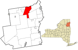
Jay is a small town in Essex County, New York, United States. In 2010, about 2,506 people lived here. The town is named after John Jay, who was a governor of New York when the town was created.
The town is on the northern edge of Essex County. It is about 34 miles southwest of Plattsburgh. Jay is located inside the beautiful Adirondack Park.
Contents
History of Jay
The area was first known as "Mallory's Bush." This name came from an early settler, Nathaniel Mallory, who arrived around 1797.
The town of Jay was officially formed in January 1798. It was created from a part of the town of Willsboro. Jay was named to honor New York Governor John Jay. Later, parts of Jay were used to form other towns. These included Keene (in 1808) and Elizabethtown and Wilmington (in 1821). In 1822, Jay grew bigger. It gained land from the towns of Chateaugay and Peru.
In the early days, making Lumber and digging for iron ore were very important jobs in Jay.
A fun amusement park called Land of Makebelieve used to be in Upper Jay. It was open from 1954 to 1979.
Geography of Jay
The town of Jay covers about 68.11 square miles (176.4 square kilometers). Most of this area is land. Only a small part, about 0.45 square miles (1.1 square kilometers), is water.
The northern border of the town is partly marked by the Ausable River. This river also forms part of the border with Clinton County. The East Branch of the Ausable River flows north through the town. It runs close to the western edge of Jay.
New York State Route 9N is a main road that goes north and south through the town. It follows the path of the East Branch of the Ausable River. Another road, New York State Route 86, goes west from NY-9N in the small community of Jay.
Population and People
| Historical population | |||
|---|---|---|---|
| Census | Pop. | %± | |
| 1820 | 1,647 | — | |
| 1830 | 1,729 | 5.0% | |
| 1840 | 2,258 | 30.6% | |
| 1850 | 2,688 | 19.0% | |
| 1860 | 2,514 | −6.5% | |
| 1870 | 2,496 | −0.7% | |
| 1880 | 2,443 | −2.1% | |
| 1890 | 1,933 | −20.9% | |
| 1900 | 1,744 | −9.8% | |
| 1910 | 2,231 | 27.9% | |
| 1920 | 2,226 | −0.2% | |
| 1930 | 2,153 | −3.3% | |
| 1940 | 2,226 | 3.4% | |
| 1950 | 2,181 | −2.0% | |
| 1960 | 2,257 | 3.5% | |
| 1970 | 2,132 | −5.5% | |
| 1980 | 2,221 | 4.2% | |
| 1990 | 2,244 | 1.0% | |
| 2000 | 2,306 | 2.8% | |
| 2010 | 2,506 | 8.7% | |
| 2016 (est.) | 2,449 | −2.3% | |
| U.S. Decennial Census | |||
In 2000, there were 2,306 people living in Jay. These people lived in 918 households, and 651 of these were families. The town had about 34 people per square mile.
About 30.2% of households had children under 18 living with them. Most households (58.0%) were married couples living together. About 29.0% of households were not families.
The average household had 2.50 people. The average family had 2.92 people. The median age in the town was 40 years old.
The median income for a household in Jay was $35,612. For families, the median income was $39,954. About 8.7% of all people in Jay lived below the poverty line. This included 7.8% of those under 18.
Communities and Places in Jay
- Au Sable Acres – This is a private neighborhood in the northwest part of town. Many people live here all year, and some visit seasonally. It is south of the West Branch of the Ausable River.
- Au Sable Forks – This is a small community, called a hamlet. It is on the northern town line and extends into Clinton County. The hamlet is where the West and East Branches of the Ausable River meet.
- Green Street – A hamlet in the northeast part of town. It is southeast of Au Sable Forks.
- North Jay – Another hamlet in the northeast section of the town. It is located on Stickney Bridge Road.
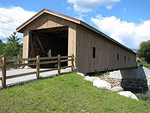
- Jay (formerly "Mallory's Bush") – This hamlet was once known as Lower Jay. It is on New York State Route 9N by the East Branch of the Ausable River. It is thought to be the oldest settlement in the town. Jay is famous for its covered bridge. The original 1857 bridge was replaced. The new covered bridge, opened in 2007, uses some of the old hand-hewn beams.
- Jersey Section – A small neighborhood located across the Jersey Bridge. It is at the end of Main Street in the southern part of Au Sable Forks.
- Rome Section – This is a small living area west of Au Sable Forks. It is along the West Branch of the Au Sable River.
- The Grove – A small community of homes along the main part of the Ausable River. This area often had floods and ice jams. In 1997, it was the first community in Jay to get help after a big flood in 1996.
- Upper Jay (formerly "Mallory's Bush") – A hamlet in the southwest corner of the town. It is on NY-9N, along the East Branch of the Au Sable River. The Land of Makebelieve amusement park used to be here. The park was lost due to floods. Some important buildings here are listed on the National Register of Historic Places. These include the Keith and Branch Ford Motors Factory and Showroom, Wells Memorial Library, and Wellscroft.
Notable People from Jay
- Earl Finch (1830–1888), a lawyer and politician who served in the Wisconsin State Assembly.
- Isaac Finch (1783–1845), a congressman who represented New York.
See also
 In Spanish: Jay (Nueva York) para niños
 | Selma Burke |
 | Pauline Powell Burns |
 | Frederick J. Brown |
 | Robert Blackburn |

