Dorrington, California facts for kids
Quick facts for kids
Dorrington
|
|
|---|---|

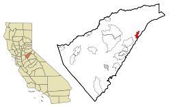
Location in Calaveras County and the state of California
|
|
| Country | United States |
| State | California |
| County | Calaveras |
| Area | |
| • Total | 4.10 sq mi (10.61 km2) |
| • Land | 4.09 sq mi (10.60 km2) |
| • Water | 0.01 sq mi (0.01 km2) 0.14% |
| Elevation | 4,767 ft (1,453 m) |
| Population
(2020)
|
|
| • Total | 519 |
| • Density | 126.80/sq mi (48.96/km2) |
| Time zone | UTC-8 (Pacific (PST)) |
| • Summer (DST) | UTC-7 (PDT) |
| ZIP code |
95223
|
| Area code(s) | 209 |
| FIPS code | 06-19570 |
| GNIS feature IDs | 1656306, 2408683 |
Dorrington is a small community in Calaveras County, California. It is called a census-designated place (CDP), which means it's an area identified by the census bureau for statistical purposes. In 2020, about 519 people lived there.
Dorrington was once known as Cold Spring Ranch until 1902. This name came from a very cold spring nearby. The town is located on State Route 4. Long ago, it was a popular stop for travelers on the toll road between Murphys and Ebbetts Pass. Many people also visited Dorrington as a resort, especially those going to Calaveras Big Trees State Park.
One amazing thing about Dorrington is that it's home to the second largest Sugar Pine tree in the world! This giant tree is 32 feet (9.7 meters) around and 220 feet (67 meters) tall. The name Dorrington comes from Rebecca (Dorrington) Gardner's maiden name.
Where is Dorrington Located?
Dorrington is found in the beautiful state of California. It's part of Calaveras County. The community sits at an elevation of about 4,767 feet (1,453 meters) above sea level.
The total area of Dorrington is around 4.10 square miles (10.61 square kilometers). Almost all of this area is land, with only a tiny bit of water.
A Look at Dorrington's Past
Dorrington has an interesting history. It was first known as Cold Springs Ranch. The name changed to Dorrington when a post office was opened there in 1902. As mentioned, the name Dorrington honors Rebecca (Dorrington) Gardner.
A famous nature lover, John Muir, visited a huge Sugar Pine tree in Dorrington on August 22, 1900. He was with other naturalists, C. Hart Merriam and Florence Merriam Bailey. They were on a trip between Lake Tahoe and Yosemite. The post office in Dorrington closed for a short time in 1919 but reopened in 1921. It then closed permanently in 1934.
Who Lives in Dorrington?
| Historical population | |||
|---|---|---|---|
| Census | Pop. | %± | |
| 2000 | 727 | — | |
| 2010 | 609 | −16.2% | |
| 2020 | 519 | −14.8% | |
| U.S. Decennial Census | |||
The population of Dorrington has changed over the years. In 2000, there were 727 people. By 2010, the population was 609. The most recent count in 2020 showed 519 residents.
Most people living in Dorrington are White. There are also smaller groups of Asian, Native American, and Pacific Islander residents. About 5.4% of the population identifies as Hispanic or Latino.
The median age in Dorrington in 2010 was about 57.6 years old. This means that half the people were older than 57.6, and half were younger. About 12.5% of the population was under 18 years old.
See also
 In Spanish: Dorrington (California) para niños
 | Georgia Louise Harris Brown |
 | Julian Abele |
 | Norma Merrick Sklarek |
 | William Sidney Pittman |


