Ebbetts Pass facts for kids
Quick facts for kids Ebbetts Pass |
|
|---|---|

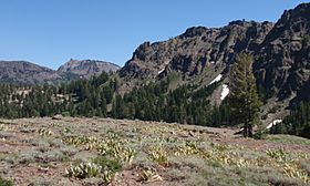
Subalpine meadow at Ebbetts Pass
|
|
| Elevation | 8,736 ft (2,663 m)NAVD 88 |
| Traversed by | |
| Location | Alpine County, California, U.S. |
| Range | Sierra Nevada |
| Coordinates | 38°32′40″N 119°48′43″W / 38.5443529°N 119.8118455°W |
| Reference #: | 318 |
Ebbetts Pass is a high mountain pass in the Sierra Nevada mountains. It is located in Alpine County, California. The pass is named after John Ebbets. It sits at an elevation of about 8,736 feet (2,663 meters).
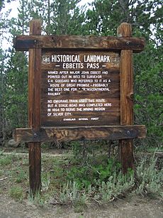
Ebbetts Pass is one of two main passes in this area. Both are crossed by California State Route 4. The other pass is Pacific Grade Summit, which is a bit lower. Ebbetts Pass is recognized as a California Historical Landmark. The famous Pacific Crest Trail, a very long hiking path, also crosses State Route 4 right at Ebbetts Pass.
Contents
Exploring Ebbetts Pass: A Journey Through Time
Who First Crossed Ebbetts Pass?
Native Americans were likely the first people to travel through the Sierra Nevada mountains. It is not known if they regularly used Ebbetts Pass. Any trails they might have used are now gone.
Some believe Jedediah Smith used this pass in 1827. He was leaving California after his first big trip. This was the first time a non-native person crossed the Sierra Nevada. Snow would have covered any trails, so he was making his own path. The Bartleson–Bidwell Party might also have used it when moving to California.
How Ebbetts Pass Got Its Name
John Ebbets was a fur trader. He later became a guide for people heading to California during the California Gold Rush. In 1851, he claimed to have led pack mules over the Sierras. He thought the pass he used would be good for a transcontinental railroad. He noticed very little snow there at the time.
Ebbets later surveyed the area for a possible railroad route. He found it was not suitable. He planned to return to survey the pass for a road. Sadly, he died in a steamboat explosion in 1854. The pass was called by his name earlier. But it was officially named Ebbetts Pass in 1893. This happened when the U.S. Geological Survey mapped the area.
From Trails to Toll Roads
The route over Ebbetts Pass was not used much at first. This changed when silver was found east of the Sierra. Merchants in Murphys built a road to Markleeville. This made it easier to bring supplies to the miners. In 1862, this road became a toll road. Travelers from Markleeville then used other established routes.
The road over Monitor Pass was finished in the early 1950s. This connected the eastern end of California State Route 4 to U.S. Route 395. This connection was made via California State Route 89.
In 1971, Ebbetts Pass became a California State Scenic Highway. It also received National Scenic Byway status in 2005. It is one of only a few such byways in California.
Traveling Ebbetts Pass Today
Today, Ebbetts Pass is one of the quietest passes in the Sierra Nevada. A 23-mile section of the road is very narrow. It is less than two lanes wide. There is no dividing line in the middle. This part of the road has very steep sections. It also has sharp, winding turns called hairpin corners.
The eastern side of the pass is especially tricky. Many hairpin corners are blind, meaning you cannot see around them. They also get steeper very suddenly. This means most cars need to shift into first gear. The pass is rarely used by big trucks. It is not recommended for vehicles pulling long trailers. Also, the pass usually closes in winter. This can be from November until May.
 | Georgia Louise Harris Brown |
 | Julian Abele |
 | Norma Merrick Sklarek |
 | William Sidney Pittman |


