Dover, Kentucky facts for kids
Quick facts for kids
Dover, Kentucky
|
|
|---|---|

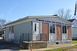
Post office on Market Street
|
|

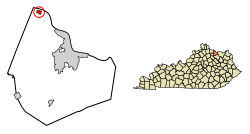
Location in Mason County, Kentucky
|
|
| Country | United States |
| State | Kentucky |
| County | Mason |
| Area | |
| • Total | 0.45 sq mi (1.16 km2) |
| • Land | 0.43 sq mi (1.12 km2) |
| • Water | 0.02 sq mi (0.05 km2) |
| Elevation | 532 ft (162 m) |
| Population
(2020)
|
|
| • Total | 221 |
| • Density | 512.76/sq mi (197.78/km2) |
| Time zone | UTC-5 (Eastern (EST)) |
| • Summer (DST) | UTC-4 (EDT) |
| ZIP code |
41034
|
| Area code(s) | 606 |
| FIPS code | 21-22222 |
| GNIS feature ID | 2403505 |
Dover is a small city in Mason County, Kentucky, United States. It is known as a "home rule-class city," which means it has the power to manage its own local affairs. In 2020, about 221 people lived there. This was a little less than the 252 people who lived there in 2010. Dover is also part of the Maysville area, which is a group of towns and cities connected by work and daily life.
Contents
Dover's Early Days: A Look at Its History
The town of Dover was first planned out in 1818 by a person named Arthur Fox Jr. It's thought that he named the town after Dover, England, which was his father's hometown. A post office, where people could send and receive mail, was opened in Dover in 1833. A few years later, in 1836, Dover officially became an incorporated city.
Where is Dover? Exploring Its Geography
Dover is located right on the south bank of the Ohio River. This means it sits next to a large and important river. To the north, across the river, is Brown County, Ohio.
A road called Kentucky Route 8 runs along the southern edge of the city. If you travel southeast on this highway, you'll reach Maysville in about 12 miles. Maysville is the main town for Mason County. If you go west on the same highway, you'll find Augusta about 7 miles away.
The city of Dover covers a total area of about 0.45 square miles. Most of this area is land, but a small part, about 0.02 square miles, is water.
Who Lives in Dover? A Snapshot of Its Population
| Historical population | |||
|---|---|---|---|
| Census | Pop. | %± | |
| 1860 | 296 | — | |
| 1870 | 532 | 79.7% | |
| 1880 | 446 | −16.2% | |
| 1890 | 515 | 15.5% | |
| 1900 | 879 | 70.7% | |
| 1910 | 386 | −56.1% | |
| 1920 | 377 | −2.3% | |
| 1930 | 418 | 10.9% | |
| 1940 | 353 | −15.6% | |
| 1950 | 334 | −5.4% | |
| 1960 | 718 | 115.0% | |
| 1970 | 277 | −61.4% | |
| 1980 | 305 | 10.1% | |
| 1990 | 297 | −2.6% | |
| 2000 | 316 | 6.4% | |
| 2010 | 252 | −20.3% | |
| 2020 | 221 | −12.3% | |
| U.S. Decennial Census | |||
According to the census from the year 2000, there were 316 people living in Dover. These people made up 115 households, and 93 of these were families.
About 35.7% of the households had children under the age of 18 living with them. Many households, 62.6%, were married couples living together. Some households, 15.7%, had a female head of the house without a husband present. About 16.5% of all households were made up of people living alone.
The average size of a household in Dover was about 2.75 people. For families, the average size was about 3.00 people.
The population in Dover was spread out by age. About 29.7% of the people were under 18 years old. About 13.9% of the people were 65 years old or older. The median age, which is the middle age of all the people, was 35 years.
See also
 In Spanish: Dover (Kentucky) para niños
 | John T. Biggers |
 | Thomas Blackshear |
 | Mark Bradford |
 | Beverly Buchanan |

