Downe Township, New Jersey facts for kids
Quick facts for kids
Downe Township, New Jersey
|
||
|---|---|---|
|
Township
|
||

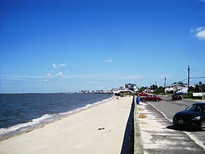
Fortescue Beach in Downe Township
|
||
|
||

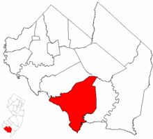
Location of Downe Township in Cumberland County highlighted in red (right). Inset map: Location of Cumberland County in New Jersey highlighted in red (left).
|
||

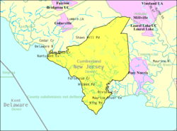
Census Bureau map of Downe Township, New Jersey
|
||
| Country | ||
| State | ||
| County | Cumberland | |
| Royal charter | January 19, 1748 | |
| Incorporated | February 21, 1798 | |
| Government | ||
| • Type | Township | |
| • Body | Township Committee | |
| Area | ||
| • Total | 54.26 sq mi (140.54 km2) | |
| • Land | 48.40 sq mi (125.36 km2) | |
| • Water | 5.86 sq mi (15.18 km2) 10.80% | |
| Area rank | 30th of 565 in state 3rd of 14 in county |
|
| Elevation | 0 ft (0 m) | |
| Population
(2020)
|
||
| • Total | 1,399 | |
| • Estimate
(2023)
|
1,382 | |
| • Rank | 517th of 565 in state 11th of 14 in county |
|
| • Density | 28.9/sq mi (11.2/km2) | |
| • Density rank | 560th of 565 in state 14th of 14 in county |
|
| Time zone | UTC−05:00 (Eastern (EST)) | |
| • Summer (DST) | UTC−04:00 (Eastern (EDT)) | |
| ZIP Code | ||
| Area code(s) | 856 exchange: 785 | |
| FIPS code | 3401118220 | |
| GNIS feature ID | 0882061 | |
Downe Township is a small community in Cumberland County, New Jersey. It is a type of local government area called a township. For official statistics, it is part of the Vineland-Bridgeton area. In 2020, about 1,399 people lived there. This was a small decrease from the 1,585 people counted in 2010.
Contents
History of Downe Township
Downe Township has a long history. It was first created on January 19, 1748. This happened through a special document called a Royal charter. At that time, it was known as "Downes Township." Later, on February 21, 1798, it officially became one of New Jersey's first 104 townships. Over time, some parts of Downe Township were used to form other townships. For example, Commercial Township was created from parts of Downe Township in 1874.
Exploring Downe Township's Geography
According to the U.S. Census Bureau, Downe Township covers about 54.26 square miles (140.54 square kilometers). Most of this area is land, about 48.40 square miles (125.36 square kilometers). The rest, about 5.86 square miles (15.18 square kilometers), is water.
Communities and Places in Downe
Many small communities and places are found within Downe Township. These include Beadons Point, Beaver Dam, and Dividing Creek. Other notable spots are Dragston, Egg Island Point, and Fortescue. You can also find Gandys Beach and Money Island here. Money Island is surrounded by a nature preserve. Other places include Nantuxent Point, Newport, and Newport Landing. Newport Neck, Newport Station, Shaws Mill, The Glades, and Turkey Point are also part of the township.
Fortescue: A Fishing Hotspot
Fortescue was once very famous. People called it the "weakfish capital of the world." Weakfish are a type of fish. However, the number of these fish has gone down a lot. This has affected the local economy in the area.
Downe Township's Neighbors
Downe Township shares its borders with other places. In Cumberland County, it borders Commercial Township, Lawrence Township, and Millville. It also borders the Delaware Bay, which is a large body of water.
Population Changes in Downe Township
| Historical population | |||
|---|---|---|---|
| Census | Pop. | %± | |
| 1810 | 1,501 | — | |
| 1820 | 1,749 | 16.5% | |
| 1830 | 1,923 | 9.9% | |
| 1840 | 1,920 | −0.2% | |
| 1850 | 2,341 | 21.9% | |
| 1860 | 3,114 | 33.0% | |
| 1870 | 3,385 | 8.7% | |
| 1880 | 1,687 | * | −50.2% |
| 1890 | 1,793 | 6.3% | |
| 1900 | 1,833 | 2.2% | |
| 1910 | 1,519 | −17.1% | |
| 1920 | 1,322 | −13.0% | |
| 1930 | 1,574 | 19.1% | |
| 1940 | 1,546 | −1.8% | |
| 1950 | 1,786 | 15.5% | |
| 1960 | 1,870 | 4.7% | |
| 1970 | 1,777 | −5.0% | |
| 1980 | 1,803 | 1.5% | |
| 1990 | 1,702 | −5.6% | |
| 2000 | 1,631 | −4.2% | |
| 2010 | 1,585 | −2.8% | |
| 2020 | 1,399 | −11.7% | |
| 2023 (est.) | 1,382 | −12.8% | |
| Population sources: 1810–2000 1810–1920 1840 1850–1870 1850 1870 1880–1890 1890–1910 1910–1930 1940–2000 2000 2010 2020 * = Lost territory in previous decade |
|||
The population of Downe Township has changed over many years. In 2010, there were 1,585 people living there. By 2020, the population had decreased to 1,399 people. This was a drop of 186 people. The population also decreased slightly between 2000 and 2010.
Education for Students in Downe Township
Students in Downe Township attend different schools depending on their age.
Local Schools
The Downe Township School District serves younger students. Children in pre-kindergarten through eighth grade go to Downe Township School. In the 2018–19 school year, this school had 186 students. There were 17 teachers, meaning about 10.9 students per teacher. This makes it one of the smaller school districts in New Jersey.
High School Education
For high school, students in ninth through twelfth grades attend Bridgeton High School. This school is located in Bridgeton. Downe Township has a special agreement with the Bridgeton Public Schools for this. In the 2018–19 school year, Bridgeton High School had 1,404 students.
Technical Education Opportunities
Students in Downe Township can also choose to attend the Cumberland County Technical Education Center. This school is in Vineland. It offers full-time technical training programs. These programs are free for students who live in Cumberland County.
Transportation in Downe Township
As of 2010, Downe Township had about 54.68 miles of roads. The local government maintains about 21.99 miles of these roads. Cumberland County maintains the other 32.69 miles. The main roads that go through Downe Township are County Route 553 and County Route 555.
See also
 In Spanish: Municipio de Downe para niños
 | Audre Lorde |
 | John Berry Meachum |
 | Ferdinand Lee Barnett |


