Dragoon Mountains facts for kids
Quick facts for kids Dragoon Mountains |
|
|---|---|

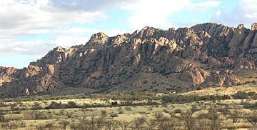
Dragoon Mountains viewed from the south.
|
|
| Highest point | |
| Peak | Mount Glenn |
| Elevation | 7,520 ft (2,290 m) |
| Dimensions | |
| Length | 43 mi (69 km) north to south |
| Width | 35 mi (56 km) east to west Extent includes low land hills and valleys |
| Area | 921 sq mi (2,390 km2) |
| Geography | |
| Country | United States |
| State | Arizona |
| Region | Madrean Sky Islands |
| District | Cochise County |
| Borders on | Little Dragoon Mountains-NW Sulphur Springs Valley-NE San Pedro Valley (Arizona)-W & SW |
The Dragoon Mountains are a mountain range in Cochise County, Arizona. This range stretches for about 25 miles (40 km) from north to south. It runs through the area near Willcox.
The mountains got their name from the 3rd U.S. Cavalry Dragoons. These were soldiers who rode horses. They had conflicts with the Chiricahua people, including their leader Cochise, during the Apache Wars. The Dragoons set up military posts around 1856. This was after the Gadsden Purchase made the area part of the United States.
Contents
Where are the Dragoon Mountains?
This mountain range is located south of Interstate 10. To the west, you'll find the Whetstone Mountains. To the east are the Chiricahua Mountains.
The higher parts of these mountains are special. They are part of the Madrean Sky Islands ecoregion. This means they have unique "sky island" habitats. Imagine tall mountains rising like islands out of a flat desert. These mountain tops are cooler and wetter. They have different plants and animals than the land around them.
Mount Glenn is the tallest point in the Dragoon Mountains. It stands 7,520 feet (2,292 meters) high. The Little Dragoon Mountains are just a continuation of this range. They are found north of an area called Texas Canyon.
The Dragoon Mountains were once part of the short-lived Dragoon National Forest. This forest was created in 1907. It later became part of the Coronado National Forest in 1908. Today, the area is managed by the Douglas Ranger District.
What is the history of the Dragoon Mountains?
The famous warrior Cochise and his group had a conflict with Union soldiers here. This was at the First Battle of Dragoon Springs. A few days later, Cochise's group was defeated at the Second Battle of Dragoon Springs.
Today, you can visit the Cochise Stronghold Memorial Park. It is located near Mount Glenn on the eastern side of the mountains. The historic town of Tombstone is also nearby. It is found in the southwestern part of the range. There are also several ghost towns in the Dragoon Mountains. These include Gleeson and Courtland. These towns were once busy but are now mostly empty.
Can you climb in the Dragoon Mountains?
People have been climbing in the Cochise Stronghold area since 1966. Early climbers like John Rupley and Fred Becky explored new routes. In 1967, a group including Joanna McComb and Don Morris tried to reach the top of Rockfellow Dome. They didn't make it to that specific summit. But they found other great climbing paths.
Later, in 1972, Dave Baker and his friends started climbing here. More climbers joined them over time. This group eventually reached the tops of Rockfellow Dome, End Pinnacle, and Cochise Dome. Their efforts started what is called the "Golden Age" of first climbs in Cochise. This means many new climbing routes were discovered during that time.
Other important climbers like Steve Grossman and Paul Davidson also created new routes. In 1979, they successfully climbed a route they named "As the Wind Cries." This took them to the top of Chey Deas Tsay. It was the last major dome in Cochise Stronghold that had not been climbed yet.
See also
 In Spanish: Sierra de la Peñascosa para niños
 | Roy Wilkins |
 | John Lewis |
 | Linda Carol Brown |


