Drayton, Hampshire facts for kids
Quick facts for kids Drayton |
|
|---|---|
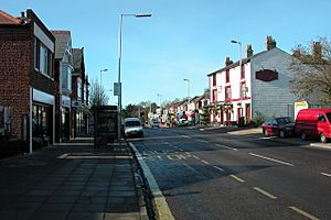
 Drayton is astride a part-commercial, part-residential street, Havant Road |
|
| Population | 13,054 (2011 Census. Drayton and Farlington Ward) |
| Unitary authority | |
| Ceremonial county | |
| Region | |
| Country | England |
| Sovereign state | United Kingdom |
| Post town | PORTSMOUTH |
| Postcode district | PO6 |
| Dialling code | 023 |
| Police | Hampshire |
| Fire | Hampshire |
| Ambulance | South Central |
| EU Parliament | South East England |
| UK Parliament |
|
Drayton is a residential area in the city of Portsmouth, located in Hampshire, England. It is part of one of the city's electoral wards, which are like local voting districts. Drayton shares this ward with Farlington.
Contents
Drayton's History
Early Beginnings
Drayton was first mentioned in a document from the year 1250. At that time, it was known as a manor (a large estate) within the Farlington parish. King Henry III gave half of the land in Drayton to a person named Roger de Merlay. In the 1300s, the area was sometimes called Dreton.
Part of the Mainland
Unlike most of Portsmouth, which is on Portsea Island, Drayton is located on the mainland. It is thought that Drayton was included in the Domesday Book of 1086 under the entry for Cosham. The Domesday Book was a famous survey of England ordered by William the Conqueror. Both Drayton and Cosham were confirmed to be part of Farlington parish a few decades later.
Joining Portsmouth
Drayton officially became part of Portsmouth in 1920. This happened because many new homes were being built in the area. Also, Drayton had strong economic ties with the city, meaning people often worked or shopped in Portsmouth.
In the early 1900s, Drayton was growing from a small village into a residential area. New houses were being built, especially in the Drayton building estate. Drayton Manor, a large home, was also located there.
Historic Buildings
The New Inn, a historic building, still stands today. It is protected under UK law as a 'grade II listed' building, which means it is an important historical structure. East of a block of flats, there is also an old milestone, which is equally protected.
Community and Amenities
Local Schools
Drayton has schools for young people:
- Solent Junior School
- Springfield School
Churches and Community Centres
- Church of England: The Church of the Resurrection and its hall are located on Havant Road. The first stone for the church was laid in 1930. This church helps the community by running a food bank and a regular market for fairtrade goods. Fairtrade means that farmers and workers get a fair price for their products.
- United Reformed and Methodist Church: Drayton United Church is a joint church for both Methodist and United Reformed groups. It is also on Havant Road. The building was built in the early 1900s and has windows that look like they are from medieval times.
- Catholic Church: St Colman's Church and its Hall are in Cosham, about 600 metres west of the Church of the Resurrection. It is surrounded by green landscaped grounds.
Past Railway Connections
Former Train Station
Station Road in Drayton was once home to the Farlington Racecourse station. This station closed in 1938 and has since been taken down. Interestingly, Portsmouth now has two "Station Roads" that do not have active railway stations.
Railway Triangle
Drayton also gives its name to the Drayton Railway Triangle. This area is home to the large Railway Triangle Industrial Estate, which is a place where many businesses and factories are located. You can reach it from Walton Road in Drayton.

