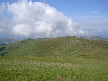
Drum (Wales) facts for kids
Quick facts for kids Drum (Carnedd Penyborth-Goch) |
|
|---|---|

Carnedd y Ddelw (Left) and Drum (Wales) (Right) from Foel-fras.
|
|
| Highest point | |
| Elevation | 771 m (2,530 ft) |
| Prominence | 48 m (157 ft) |
| Listing | Hewitt, Nuttall |
| Naming | |
| English translation | ridge |
| Language of name | Welsh |
| Geography | |
| Location | Conwy / Gwynedd, Wales |
| Parent range | Snowdonia |
| OS grid | SH708695 |
Drum is a mountain in the beautiful Snowdonia area of north Wales. It is part of the Carneddau mountain range. Drum stands tall at 771 meters (about 2,526 feet) high. Its name comes from the Welsh language, where "Y Drum" means "the ridge." It is also sometimes called Carnedd Penyborth-Goch.
What is Drum?
Drum is a mountain summit, which means it is one of the highest points in its area. It is located about 2 kilometers (1.2 miles) north-east of another mountain called Foel-fras. Being a "ridge" means it has a long, narrow top, like the back of a giant animal.
Where is Drum Located?
Drum is found in the northern part of the Carneddau mountains. This mountain range is in north Wales. The Carneddau mountains are known for their wild, open spaces and amazing views. They are a popular place for hiking and exploring.
Water Flowing from Drum
The eastern side of Drum has water flowing down its slopes. This water forms a stream called the Afon Tafolog. An "afon" is the Welsh word for river. The Afon Tafolog then flows into another river called Afon Roe.
The Afon Roe passes through a small village named Rowen. Finally, the water from Drum joins the larger River Conwy. This river flows into the sea, carrying water from many mountains in the area.
 | Kyle Baker |
 | Joseph Yoakum |
 | Laura Wheeler Waring |
 | Henry Ossawa Tanner |

