
Foel-fras facts for kids
Quick facts for kids Foel-fras |
|
|---|---|

|
|
| Highest point | |
| Elevation | 944 m (3,097 ft) |
| Prominence | 63 m (207 ft) |
| Parent peak | Carnedd Llewelyn |
| Listing | Hewitt, Welsh 3000s, Nuttall, Furth |
| Naming | |
| English translation | broad hill |
| Language of name | Welsh |
| Geography | |
| Location | Snowdonia, Wales |
| OS grid | SH696681 |
| Topo map | OS Landranger 115 |
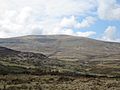
Foel-fras is a tall mountain in North Wales. It stands 944 meters (3,097 feet) high. This makes it the eleventh highest mountain in all of Wales. Its name means "broad hill" in the Welsh language.
Foel-fras is part of the Carneddau mountain range. It is located about 10 kilometers (6 miles) east of a town called Bethesda. The mountain sits right on the edge between two counties, Gwynedd and Conwy.
This mountain is at the northern end of the main Carneddau ridge. To its north is Drum mountain. To its south is Foel Grach. A slightly smaller peak, Garnedd Uchaf, is between Foel-fras and Foel Grach. Below Foel-fras, you can find two reservoirs. Llyn Dulyn is to the south, and the smaller Llyn Anafon is to the north.
Contents
Hiking to the Top
Foel-fras is a popular mountain for hikers. It is often the first peak people reach when doing the "Welsh 3000s" challenge. This challenge involves climbing all 15 mountains in Wales that are over 3,000 feet (914 meters) high.
Routes from the North
One way to climb Foel-fras starts from the village of Abergwyngregyn. You can drive up a small road towards Aber Falls. After passing the car park for the falls, you continue to a smaller car park at the end of the road.
From this car park, you have two main choices:
- You can take a track that goes left, then turns right. This path leads you to the top of Drum. From there, you follow the ridge to Foel-fras.
- Another option is to take the track that goes straight ahead. This path leads to Llyn Anafon. From the lake, you climb up to the ridge between Drum and Foel-fras.
Routes from the West
Another way to reach the mountain starts from the western end of the Bwlch-y-Ddeufaen pass. This route involves a steep climb up the side of a hill called Drosgyl. You follow a fence line for a long time. When the ground levels out, you will see wide views. The fence changes direction here.
From this point, you follow a small track southwest. This track will meet a larger path marked by a small pile of stones. This larger path leads to Drum mountain. From Drum, the walk to the top of Foel-fras is easy. You just walk next to a fence line, which turns into a stone wall as you get closer to the summit. You can park your car at the eastern end of the Bwlch-y-Ddeufaen pass.
Route from Llanfairfechan
You can also start your hike from the village of Llanfairfechan. This route is also very scenic. You follow the road up through the village until you reach Terrace Walk. From Terrace Walk, a path takes you past Hengae Farm. Then, you follow a path that can lead you to the tops of Garreg Fawr, Drum, Foel-fras, and other peaks.
Bird Watching
The flat top of Foel-fras is a special place for watching birds. It is one of the best spots in Wales to see a bird called the dotterel. These birds stop here during their spring and autumn migrations. They are traveling between their breeding grounds and their winter homes.
Images for kids
-
Foel-fras from Cwm Eigiau

