
Dugway Range facts for kids
Quick facts for kids Dugway Range |
|
|---|---|

Dugway Range-(horizon, photo left, ~16 mi)
view (north-northwest) of Topaz Mtn, (Thomas Range, north Sevier Desert) |
|
| Highest point | |
| Peak | Castle Mountain (Utah) |
| Elevation | 6,748 ft (2,057 m) |
| Dimensions | |
| Length | 13 mi (21 km) NW x SE (Dugway Ridge, extends 2.5 mi southwest, from southern terminus) |
| Geography | |

Dugway Range
Location in Utah
|
|
| Country | United States |
| Communities | Fish Springs, Callao and Dugway |
The Dugway Range is a mountain range in Utah. It's about 13 miles (21 km) long. You can find it in central-south Tooele County, right near the northern border of Juab County.
This range stretches northwest into the southern part of the Great Salt Lake Desert. This desert is huge, about three times the size of the Great Salt Lake itself! It's famous for its flat, white salt flats, like the Bonneville Salt Flats.
Just 4 miles north of the Dugway Range is Granite Mountain. This 8-mile long mountain was a famous landmark for travelers in the 1800s. People even drew pictures of it back in 1859!
Contents
What is the Dugway Range Like?
The Dugway Range is about 13 miles long. It has a smaller ridge that sticks out from its southern end. This ridge, called Dugway Ridge, goes southwest for about 2.5 miles. It ends at a spot called Pyramid Peak, which is 6,120 feet (1,865 meters) high.
The tallest point in the range is Castle Mountain (Utah). It stands at 6,748 feet (2,057 meters) tall. You'll find it near the middle of the range's main ridgeline.
Nearby Landforms and Features
The Great Salt Lake is about 4,200 feet (1,280 meters) above sea level. The Bonneville Salt Flats are a bit higher, at 4,219 feet (1,286 meters). The flat areas around the Dugway Range are also around 4,220 feet (1,286 meters) high.
To the southwest, you'll find some actual foothills above the desert's salt flats. Water flows off the southwest side of the range. These streams then meet in a shallow valley. From there, three streams flow northwest towards the Great Salt Lake Desert's salt flat.
Close by to the southwest are the Black Rock Hills. These hills are circular and about 5 miles across. They reach 5,554 feet (1,693 meters) high. They are about 4 miles east of the Fish Lakes. They are also about 8 miles southwest of the Dugway foothills.
Northeast of the Dugway Range are more of the Great Salt Lake Desert's salt flats. These flats stretch southeast along the range's northeast side. They meet the end of the Dugway Valley to the northwest. The Dugway Valley itself goes mostly southeast for about 17 miles.
The valley contains Table Mountain Reservoir, which is a small lake. It's about 0.15 miles wide. This reservoir is 3 miles west of Table Mountain, which is 5,766 feet (1,757 meters) high.
Hills and flat areas with many cuts border the valley's northeast side. Also, following the same northwest direction as the Dugway Range, is the Old River Bed. This winding path is about 15 miles long and has a road called Old River Bed Road.
South of the range, at Pony Express Road, is Dugway Pass. From here, the Dugway foothills blend into the northern foothills of the Thomas Range to the south.
Next to the southern end of Granite Mountain is a small rock "island" called Sapphire Mountain. It's 4,791 feet (1,460 meters) high and about 1.5 miles long. Sapphire Mountain is 2.5 miles from the Dugway foothills. It's also only 0.5 miles from the edge of Granite Mountain.
How to Visit the Dugway Range
You can reach the Dugway Range using unpaved roads from the west. This area is near the Fish Springs National Wildlife Refuge, which is at the northern part of the Fish Springs Range.
These routes can be accessed from Callao, which is 17 miles west. Callao is about 12 miles from the Dugway Range. One route from Fish Springs is called Pony Express Road. It goes around the southern end of the range and the Pyramid Peak spur.
From Pony Express Road, another unpaved road circles the mountain range. This road goes northwest, north, and east around the range. It is about 27 miles long.
You can also get to the range from the east or northeast. This is from Dugway, using Utah State Route 199 and Utah 196, then unpaved roads. Dugway is about 30 miles northeast of the Dugway Range.
Off-road paths can take you to Granite Mountain (Tooele County, Utah) from the northern end of the Dugway Range. Granite Mountain is 4 miles away across the salt flat desert. Other routes from the east, near Dugway, also lead to the eastern part of Granite Mountain.
Images for kids
-
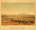
A traveling landmark: Granite Mountain (Tooele County, Utah), an 1859 art sketch

