Dyer Mountain facts for kids
Quick facts for kids Dyer Mountain |
|
|---|---|

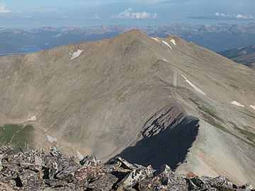
Dyer Mountain, seen from Gemini Peak
|
|
| Highest point | |
| Elevation | 13,862 ft (4,225 m) |
| Prominence | 475 ft (145 m) |
| Isolation | 0.88 mi (1.42 km) |
| Geography | |
| Location | Lake and Park counties, Colorado, United States |
| Parent range | Mosquito Range |
| Topo map | USGS 7.5' topographic map Mount Sherman, Colorado |
| Climbing | |
| Easiest route | hike |
Dyer Mountain is a very tall mountain peak in the Mosquito Range. This mountain range is part of the larger Rocky Mountains in North America. Dyer Mountain is located in the state of Colorado, United States.
The mountain stands at 13,862 feet (about 4,225 meters) above sea level. It is about 9.5 kilometers (6 miles) east of the city of Leadville. Dyer Mountain sits right on the border between Lake County and Park County.
What is a Thirteener?
In Colorado, mountains are often grouped by their height. Peaks over 14,000 feet are called "Fourteeners." These are very famous and popular to climb.
Dyer Mountain is just under this height. It is known as a "Thirteener." This means its summit is between 13,000 and 13,999 feet tall.
Where is Dyer Mountain?
Dyer Mountain is found in the central part of Colorado. It is part of the Mosquito Range, which is a sub-range of the Rocky Mountains. This area is known for its beautiful, rugged peaks.
The mountain is a natural boundary. It marks the edge between two counties: Lake County and Park County. This border runs along the top of the mountain.
Who was John Lewis Dyer?
Dyer Mountain was named in honor of a man named John Lewis Dyer. He was a famous frontier preacher. A "frontier preacher" was someone who traveled to new, unsettled areas to share religious messages.
John Lewis Dyer was known for his dedication and travels across the rugged Colorado landscape. Naming the mountain after him was a way to remember his contributions to the region's history.
Exploring the Area
The area around Dyer Mountain is popular for outdoor activities. Many people enjoy hiking and climbing in the Mosquito Range. The easiest way to reach the top of Dyer Mountain is by hiking.
The mountain is part of a "drainage divide." This means that rain or snow falling on one side of the mountain flows into one river system. Water on the other side flows into a different river system. It's like a natural split for water.
 | Aurelia Browder |
 | Nannie Helen Burroughs |
 | Michelle Alexander |


