Dysart, Queensland facts for kids
Quick facts for kids DysartQueensland |
|||||||||||||||
|---|---|---|---|---|---|---|---|---|---|---|---|---|---|---|---|

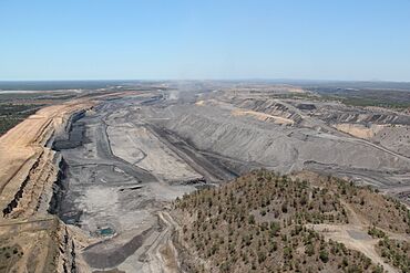
Saraji coal mine, Dysart, 2012
|
|||||||||||||||
| Population | 2,918 (2021 census) | ||||||||||||||
| • Density | 0.84350/km2 (2.1847/sq mi) | ||||||||||||||
| Postcode(s) | 4745 | ||||||||||||||
| Elevation | 223 m (732 ft) | ||||||||||||||
| Area | 3,459.4 km2 (1,335.7 sq mi) | ||||||||||||||
| Time zone | AEST (UTC+10:00) | ||||||||||||||
| Location |
|
||||||||||||||
| LGA(s) | Isaac Region | ||||||||||||||
| State electorate(s) | Burdekin | ||||||||||||||
| Federal Division(s) | Capricornia | ||||||||||||||
|
|||||||||||||||
|
|||||||||||||||
Dysart is a town in the Isaac Region of Queensland, Australia. It is a key place that helps support the many mines and farms in the area. In 2021, about 2,918 people lived in Dysart. Most of the people who live here work in the coal mines.
Contents
Exploring Dysart's Location
Train Connections
Dysart is connected by the Goonyella railway network. This railway system links the coal mines in the Bowen Basin Coalfields to the coal shipping docks at Hay Point on the coast. This helps move coal from the mines to other places.
The town has its own train station, called Dysart railway station (22°35′09″S 148°21′50″E / 22.5858°S 148.3638°E).
Nearby Mountains
The area around Dysart has many mountains. Some of the notable peaks include:
- Walkers Peak, which is 438 meters high.
- Mount Phillips, standing at 681 meters.
- Mount Walker, which is 390 meters tall.
- Campbell Peak, reaching 430 meters.
- Gilberts Dome, the tallest at 742 meters.
- Browns Peak, at 807 meters.
- Charleys Peak, 610 meters high.
- Eastern Peak, also 610 meters tall.
- Mount Dalrymple, 472 meters high.
- Expedition Peak, at 430 meters.
Dysart's Past
The first European to explore this region was Ludwig Leichhardt in 1845. He even climbed Campbell Peak nearby.
The town of Dysart was created in 1973. It was built to support the Saraji coal mine. The name Dysart comes from an old local farm and means "a quiet place for monks" or "solitude" in Irish Gaelic.
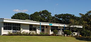
Dysart State School opened its doors on May 21, 1973. A high school section was added in 1979, and then Dysart State High School opened as a separate school in 1980. The Dysart Library started in 1982.
In 2011, Dysart was known for having very high rent prices for houses. However, after the Norwich Park Mine closed in 2012, property prices began to drop. By 2015, renting a three-bedroom home became much more affordable.
People of Dysart
The number of people living in Dysart has changed a little over the years:
- In 2011, there were 3,003 people.
- In 2016, the population was 2,991 people.
- In 2021, about 2,918 people lived in Dysart.
Dysart's Economy
The economy of Dysart is mainly based on coal mining. The Norwich Park coal mine was a big part of the town's economy for 32 years, but it closed in 2012. Many miners then moved to work at the Saraji coal mine, which is one of the largest coal mines in the world. In 2020, the Norwich Park mine reopened under a new name, Saraji South.
Learning in Dysart
Dysart has schools for all ages:
- Dysart State School is a primary school for students from Prep to Year 6. It is located on Garnham Drive (22°35′16″S 148°20′51″E / 22.5877°S 148.3475°E). In 2018, it had 347 students.
- Dysart State High School is a secondary school for students from Year 7 to Year 12. It is on Edgerley Street (22°35′02″S 148°21′17″E / 22.5840°S 148.3548°E). In 2018, 162 students attended the high school.
Sports in Dysart
Sports are a big part of life in Dysart:
- Rugby League is very popular. The junior team is called the 'Dysart Bulls', and their colors are red, black, and white. The senior team is also called the 'Dysart Bulls'. A famous player, Matt Sing, who played for Queensland in the State of Origin series, started his junior career with the Dysart Bulls.
- Soccer is also popular, with the local team known as the Dysart Devils.
Community Services
The Isaac Regional Council runs a public library in Shannon Crescent, Dysart. This library is a great place for reading and learning.
Important Facilities
Dysart has several important emergency services to keep everyone safe:
- Dysart Police Station (22°35′10″S 148°20′56″E / 22.5862°S 148.3489°E)
- Dysart Ambulance Station (22°35′08″S 148°20′58″E / 22.5855°S 148.3494°E)
- Dysart Fire Station (22°35′24″S 148°20′54″E / 22.5900°S 148.3483°E)
- Dysart SES Facility (22°35′24″S 148°20′28″E / 22.5901°S 148.3410°E)
- Dysart Mine Rescue Station (22°35′27″S 148°20′22″E / 22.5909°S 148.3394°E)
The Dysart Cemetery is located on the eastern side of town at 163 Dysart Bypass Road (22°35′22″S 148°21′33″E / 22.5895°S 148.3591°E).
Local Events
Dysart hosts the Norwich Park Mines Day. This event helps people learn more about the mining industry and how it works.
Things to See
At the northern entrance to Dysart, you can see a special monument. It features a large mining truck and a coal wagon, showing the town's connection to the coal and rail industries.
 | Mary Eliza Mahoney |
 | Susie King Taylor |
 | Ida Gray |
 | Eliza Ann Grier |


