
Eagle Crags facts for kids
Eagle Crags is a tall mountain peak in southwest Utah, United States. It stands at about 6,380 feet (1,945 meters) high. You can find it in the Canaan Mountain Wilderness area of Washington County.
Quick facts for kids Eagle Crags |
|
|---|---|

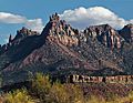
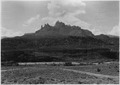
Eagle Crags, northwest aspect
|
|
| Highest point | |
| Elevation | 6,380 ft (1,940 m) |
| Prominence | 400 ft (120 m) |
| Isolation | 1.80 mi (2.90 km) |
| Parent peak | Lower Mountain (6,780 ft) |
| Geography | |

Eagle Crags
Location in Utah

Eagle Crags
Location in the United States
|
|
| Location | Canaan Mountain Wilderness Washington County, Utah, US |
| Parent range | Colorado Plateau |
| Topo map | USGS Springdale West |
| Geology | |
| Age of rock | Jurassic |
| Type of rock | Navajo sandstone |
About Eagle Crags
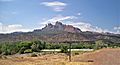
You can find Eagle Crags about 2.5 miles (4 kilometers) southeast of Rockville. It is also just 2.5 miles (4 kilometers) south of the famous Zion National Park. You can easily spot this mountain from Utah State Route 9.
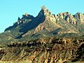
This mountain stands out! On its north side, it shoots up 2,800 feet (850 meters) in just two miles. This big climb happens above the Virgin River, where rainwater flows down from the mountain. The closest taller mountain is Lower Mountain, about 2 miles (3 kilometers) to the south.
The top part of Eagle Crags is made of light-colored rock called Navajo Sandstone. This rock formed during the Jurassic period, a very long time ago. Below it, you'll find deep-red sandstone from the Kayenta Formation. The name "Eagle Crags" was officially chosen in 1934. This was done by the United States Board on Geographic Names, which names places in the U.S.
Hiking the Eagle Crags Trail
You can explore Eagle Crags by hiking the Eagle Crags Trail. This trail is about 2.8 miles (4.5 kilometers) long. As you hike, you will gain about 900 feet (274 meters) in height.
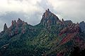
The trail takes you through different types of plants. You'll see pinyon–juniper woodland, sagebrush, and blackbrush. There are also yucca plants and cacti. The path leads you to the base of the mountain's tall rock formations. These include pinnacles, spires, and crags. From the trail, you can enjoy amazing views. You might see Mount Kinesava, Johnson Mountain, and other famous spots inside Zion National Park.
Gallery
-
-
-
North aspect
-

-
-
Eagle Crags in 1929


Climate Around Eagle Crags
The best times to visit Eagle Crags are during spring and fall. The weather is usually very pleasant then. This area has a Cold semi-arid climate. This means it's a desert climate, but it can get cold in winter. The average temperature in the coldest month is below 32 °F (0 °C).
Most of the yearly rain in this area falls during spring and summer. Eagle Crags gets less than 10 inches (254 millimeters) of rain each year. Snowfall in winter is usually light and does not last long.
